National Register of Historic Places listings in Arlington County, Virginia
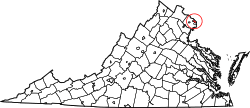
Location of Arlington County in Virginia
This is a list of the National Register of Historic Places listings in Arlington County, Virginia.
This is intended to be a complete list of the properties and districts on the National Register of Historic Places in Arlington County, Virginia, United States. The locations of National Register properties and districts for which the latitude and longitude coordinates are included below, may be seen in a Google map.[1]
There are 68 properties and districts listed on the National Register in the county, including 5 National Historic Landmarks.
- This National Park Service list is complete through NPS recent listings posted December 2, 2016.[2]
Current listings
| [3] | Name on the Register[4] | Image | Date listed[5] | Location | City or town | Description |
|---|---|---|---|---|---|---|
| 1 | Al's Motors | .JPG) |
(#03000628) |
3910 Wilson Blvd. 38°52′45″N 77°06′27″W / 38.879167°N 77.1075°W |
Ballston | Currently a Gold's Gym |
| 2 | Arlington Forest Historic District | 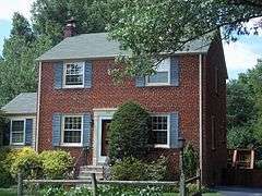 |
(#05001344) |
Bounded by Carlin Springs Rd., George Mason Dr., Henderson Rd., Aberdeen St., Columbus St., Granada, Galveston and 2nd 38°52′14″N 77°07′08″W / 38.870556°N 77.118889°W |
Arlington | part of the Historic Residential Suburbs in the United States, 1830-1960 Multiple Property Submission (MPS) |
| 3 | Arlington Heights Historic District | 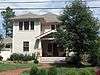 |
(#08000063) |
Bounded by Arlington Blvd., S. Fillmore St., S. Walter Reed Dr., Columbia Pk., & S. Glebe Rd. 38°52′02″N 77°05′27″W / 38.86735°N 77.090764°W |
Arlington | part of the Garden Apartments, Apartment Houses and Apartment Complexes in Arlington County, Virginia MPS |
| 4 | Arlington House, The Robert E. Lee Memorial | 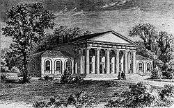 |
(#66000040) |
Arlington National Cemetery 38°52′54″N 77°04′29″W / 38.881667°N 77.074722°W |
Arlington | Boundary increase on 2014-03-17, listed as the Arlington House Historic District |
| 5 | Arlington Memorial Bridge | 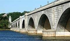 |
(#80000346) |
Spans the Potomac River 38°53′12″N 77°03′39″W / 38.886667°N 77.060833°W |
SW | Extends into central Washington, D.C. |
| 6 | Arlington National Cemetery Historic District |  |
(#14000146) |
1 Memorial Drive 38°52′48″N 77°04′12″W / 38.880000°N 77.070000°W |
Arlington | Includes the cemetery, Arlington House, Memorial Drive, and the Hemicycle |
| 7 | Arlington Ridge Park |  |
(#09000688) |
Northwest corner of N. Meade St. and Marshall Dr. 38°53′15″N 77°04′18″W / 38.887636°N 77.071722°W |
Arlington | part of the Parkways of the National Capital Region MPS |
| 8 | Arlington Village Historic District |  |
(#03000215) |
S. 13th St., S. 13 Rd., S. 16th St., S. Barton S., S. Cleveland St. and Edgewood St. 38°51′33″N 77°05′02″W / 38.859167°N 77.083889°W |
Arlington | |
| 9 | Ashton Heights Historic District |  |
(#03000561) |
Roughly bounded by Wilson Blvd., N. Irving St., Arlington Blvd., N. Oxford St., N. Piedmont & N. Oakland Sts. 38°52′38″N 77°06′04″W / 38.877222°N 77.101111°W |
Arlington | |
| 10 | Aurora Highlands Historic District |  |
(#08001018) |
Bounded by 16th St. S., S. Eads St., 26th St. S., and S. Joyce St. 38°51′16″N 77°03′28″W / 38.85445°N 77.057733°W |
Arlington | part of the Historic Residential Suburbs in the United States, 1830-1960 MPS |
| 11 | Ball-Sellers House |  |
(#75002014) |
5620 S. 3rd St. 38°51′49″N 77°07′31″W / 38.863611°N 77.125278°W |
Glencarlyn | |
| 12 | Barcroft Community House |  |
(#95000928) |
800 S. Buchanan St. 38°50′30″N 77°05′53″W / 38.8417°N 77.0981°W |
Arlington | |
| 13 | Benjamin Banneker: SW-9 Intermediate Boundary Stone | %2C_21_Oct_2012.JPG) |
(#76002094) |
18th and Van Buren Sts. 38°53′31″N 77°09′34″W / 38.8919°N 77.1594°W |
Arlington | |
| 14 | Buckingham Historic District |  |
(#98001649) |
Roughly bounded by N. 5th, N. Oxford, and N. 2nd Sts., and N. Glebe Rd.; also bounded by N. Oxford St., Fifth St. N, N. Henderson Rd., First St. N., N. Pershing, N. Thomas St., and Second St. N.; also bounded by and including N. Thomas St., 4th St. N. , N. Pershing Dr., and N. George Mason Dr. 38°52′30″N 77°06′20″W / 38.875°N 77.1056°W |
Arlington | Second and third sets of boundaries represent boundary increases of February 11, 2004 and March 23, 2010 |
| 15 | Calvert Manor |  |
(#97001506) |
1925-1927 N. Calvert St. 38°53′42″N 77°05′32″W / 38.895°N 77.0922°W |
Arlington | |
| 16 | Carlin Hall | 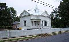 |
(#93000833) |
5711 4th St., S. 38°51′47″N 77°07′35″W / 38.8631°N 77.1264°W |
Glencarlyn | |
| 17 | Cherrydale Historic District | 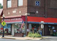 |
(#03000461) |
Roughly bounded by Lorcom Ln., N. Utah and N. Taylor Sts., and I-66 38°53′41″N 77°06′32″W / 38.8947°N 77.1089°W |
Cherrydale | |
| 18 | Cherrydale Volunteer Fire House | 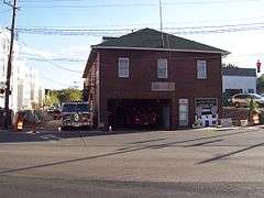 |
(#95000927) |
3900 N. Lee Hwy. 38°53′14″N 77°06′26″W / 38.8872°N 77.1072°W |
Cherrydale | |
| 19 | Claremont Historic District | 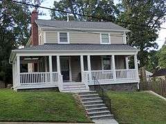 |
(#06000751) |
Bounded by S. Dinwiddie St., S. Chesterfield Rd., S. Buchanan St., 25th St. S, 24th St. S, 23rd St. S and 22nd St. S 38°50′47″N 77°06′20″W / 38.8464°N 77.1056°W |
Arlington | part of the Historic Residential Suburbs in the United States, 1830-1960 MPS |
| 20 | Clarendon School | .JPG) |
(#99001502) |
3550 Wilson Blvd. 38°52′54″N 77°06′08″W / 38.8817°N 77.1022°W |
Clarendon | Currently the Arlington Arts Center |
| 21 | Colonial Village | _02.JPG) |
(#80004170) |
Roughly bounded by Wilson Blvd., Lee Hwy., N. Veitch St. and Queens Lane 38°53′39″N 77°04′59″W / 38.8942°N 77.0831°W |
Arlington | |
| 22 | Columbia Forest Historic District |  |
(#04000047) |
Bounded by 11th, S. Edison, S. Dinwiddie, S. Columbus, S. George Mason, and S. Frederick St. 38°51′09″N 77°06′41″W / 38.8525°N 77.1114°W |
Arlington | |
| 23 | George Crossman House |  |
(#03000455) |
2501 N. Underwood St. 38°53′31″N 77°09′40″W / 38.8919°N 77.1611°W |
Arlington | |
| 24 | Dominion Hills Historic District |  |
(#12000239) |
Roughly bounded by N. Four Mile Run Dr., N. McKinley Rd., N. Larrimore, N. Madison, N. Montana Sts., & 9th St. N. 38°52′33″N 77°08′29″W / 38.8758°N 77.1413°W |
Arlington | part of the Historic Residential Suburbs in the United States, 1830-1960 MPS |
| 25 | Charles Richard Drew House |  |
(#76002095) |
2505 1st St., S. 38°52′22″N 77°05′14″W / 38.8728°N 77.0872°W |
Arlington | |
| 26 | Fairlington Historic District | 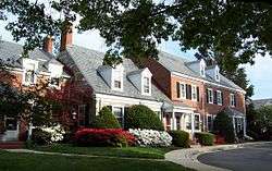 |
(#99000368) |
Roughly bounded by Quaker Lane, King St., I-395, S. Walter Reed Dr., and S. Abingdon St. 38°50′11″N 77°05′40″W / 38.836389°N 77.094444°W |
Fairlington | |
| 27 | Fort C. F. Smith Historic District | 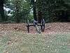 |
(#99001719) |
2411 24th St. 38°54′06″N 77°05′25″W / 38.901667°N 77.090278°W |
Arlington | |
| 28 | Fort Ethan Allen | 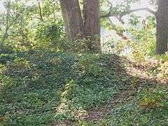 |
(#04000052) |
Address Restricted 38°55′25″N 77°07′26″W / 38.923611°N 77.123889°W |
Arlington | |
| 29 | Fort Myer Historic District | 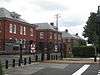 |
(#72001380) |
Arlington Blvd. (U.S. 50) 38°52′59″N 77°04′54″W / 38.883056°N 77.081667°W |
Arlington | |
| 30 | George Washington Memorial Parkway |  |
(#95000605) |
Roughly, south side of the Potomac River from American Legion to Memorial Bridge and north side from Brickyard Rd. to Chain Bridge 38°56′19″N 77°08′07″W / 38.938611°N 77.135278°W |
Arlington | part of the Parkways of the National Capital Region MPS |
| 31 | Georgetown Pike |  |
(#12000537) |
From DC/VA boundary at Chain Bridge to the junction with Leesburg Pike at Seneca Rd. 38°55′51″N 77°07′09″W / 38.930971°N 77.119246°W |
Arlington | extends into Fairfax County, Virginia |
| 32 | Glebe Center |  |
(#04000055) |
71-89 N. Glebe Rd. 38°52′18″N 77°06′08″W / 38.871794°N 77.102214°W |
Ballston | |
| 33 | The Glebe | .JPG) |
(#72001381) |
4527 17th St., N. 38°53′30″N 77°07′04″W / 38.891667°N 77.117778°W |
Arlington | Has octagon wing |
| 34 | Glebewood Village Historic District |  |
(#04000049) |
N. Brandywine St. between Lee Highway and 10th Place N., 21St Rd. between N. Brandywine St. and N. Glebe Rd. 38°53′44″N 77°07′26″W / 38.895556°N 77.123889°W |
Arlington | |
| 35 | Glencarlyn Historic District | 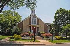 |
(#08000910) |
Bounded by S. Carlin Springs Rd., Arlington Blvd., 5th Rd. S., Glencarlyn Park 38°51′49″N 77°07′35″W / 38.863544°N 77.126394°W |
Glencarlyn | part of the Historic Residential Suburbs in the United States, 1830-1960 MPS |
| 36 | Harry W. Gray House | 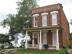 |
(#64000051) |
1005 S. Quinn St. 38°51′53″N 77°04′30″W / 38.864722°N 77.075°W |
Arlington | |
| 37 | Highland Park-Overlee Knolls | 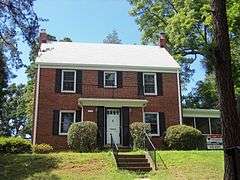 |
(#11000548) |
Roughly bounded by 22nd St. N., N. Lexington St., 16th St. N., N. Longfellow St., McKinley Rd., I-66 & N. Quantico St. 38°53′12″N 77°08′49″W / 38.886667°N 77.146944°W |
Arlington | part of the Historic Residential Suburbs in the United States, 1830-1960 MPS |
| 38 | Hume School | 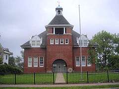 |
(#79003027) |
1805 S. Arlington Ridge Rd. 38°51′31″N 77°04′05″W / 38.858611°N 77.068056°W |
Arlington | |
| 39 | Francis Scott Key Bridge | 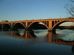 |
(#96000199) |
US 29 over the Potomac River 38°54′08″N 77°04′13″W / 38.902222°N 77.070278°W |
Arlington | |
| 40 | Lee Gardens North Historic District |  |
(#04000109) |
2300-2341 N. 11th St. 38°53′08″N 77°05′12″W / 38.885556°N 77.086667°W |
Arlington | part of the Garden Apartments, Apartment Houses and Apartment Complexes in Arlington County, Virginia MPS |
| 41 | Lomax African Methodist Episcopal Zion Church | 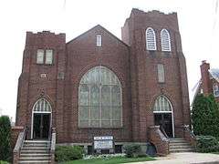 |
(#04000038) |
2704 24th Rd. S. 38°50′51″N 77°04′57″W / 38.8475°N 77.0825°W |
Arlington | |
| 42 | Lyon Park Historic District |  |
(#03000437) |
Roughly bounded by 10th St. N, Arlington Blvd., and N. Irving St. 38°52′45″N 77°05′26″W / 38.879167°N 77.090556°W |
Arlington | |
| 43 | Lyon Village Historic District |  |
(#02000512) |
Roughly bounded by Lee Highway, N. Veitch St., N. Franklin Rd., N. Highland St., N. Fillmore St., and N. Kirkwood Rd. 38°53′29″N 77°05′42″W / 38.891389°N 77.095°W |
Arlington | |
| 44 | Maywood Historic District |  |
(#03000460) |
Roughly bounded by Lorcom Ln., Spout Run Parkway, I-66, Lee Highway, N. Oakland St., N. Nelson St., and N. Lincoln St. 38°53′53″N 77°06′05″W / 38.898056°N 77.101389°W |
Arlington | |
| 45 | Monroe Courts Historic District |  |
(#08000064) |
1041-1067 N. Nelson and 1036-1062 & 1033-1055 N. Monroe Sts. 38°53′08″N 77°06′18″W / 38.885569°N 77.104936°W |
Arlington | part of the Historic Residential Suburbs in the United States, 1830-1960 MPS |
| 46 | Mount Vernon Memorial Highway |  |
(#81000079) |
Washington St. and George Washington Memorial Parkway 38°46′35″N 77°03′13″W / 38.776389°N 77.053611°W |
Arlington | |
| 47 | Northwest No. 1 Boundary Marker of the Original District of Columbia | 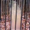 |
(#91000003) |
3607 Powhatan St. 38°54′11″N 77°09′34″W / 38.903056°N 77.159444°W |
Arlington | part of the Boundary Markers of the Original District of Columbia MPS |
| 48 | Northwest No. 2 Boundary Marker of the Original District of Columbia | 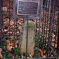 |
(#91000004) |
5145 N. 38th St. 38°54′49″N 77°08′46″W / 38.913611°N 77.146111°W |
Arlington | part of the Boundary Markers of the Original District of Columbia MPS |
| 49 | Northwest No. 3 Boundary Marker of the Original District of Columbia | 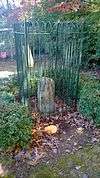 |
(#91000005) |
4013 N. Tazewell St. 38°55′29″N 77°07′59″W / 38.924722°N 77.133056°W |
Arlington | part of the Boundary Markers of the Original District of Columbia MPS |
| 50 | Penrose Historic District |  |
(#04000112) |
Roughly bounded by Arlington Blvd., S. Courthouse Rd., S. Fillmore St., S. Barton St. S, and Columbia Pike 38°52′07″N 77°05′08″W / 38.868736°N 77.085442°W |
Arlington | |
| 51 | Pentagon Office Building Complex | 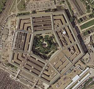 |
(#89000932) |
Jefferson Davis Highway/VA 110 at I-395. North of Pentagon City. 38°52′16″N 77°03′23″W / 38.871111°N 77.056389°W |
Pentagon City | |
| 52 | Quarters 1, Fort Myer |  |
(#72001382) |
Grant Ave. 38°52′58″N 77°04′53″W / 38.882778°N 77.081389°W |
Arlington | |
| 53 | Saegmuller House |  |
(#03000453) |
5101 Little Falls Rd. 38°54′21″N 77°08′25″W / 38.905833°N 77.140278°W |
Arlington | |
| 54 | Southwest No. 4 Boundary Marker of the Original District of Columbia |  |
(#91000009) |
King St. north of the junction with Wakefield St. 38°49′54″N 77°05′32″W / 38.831667°N 77.092222°W |
Alexandria | part of the Boundary Markers of the Original District of Columbia MPS |
| 55 | Southwest No. 5 Boundary Marker of the Original District of Columbia | 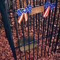 |
(#91000010) |
Northeast of the junction of King St. and Walter Reed Dr. 38°50′31″N 77°06′22″W / 38.841944°N 77.106111°W |
Arlington | part of the Boundary Markers of the Original District of Columbia MPS |
| 56 | Southwest No. 6 Boundary Marker of the Original District of Columbia | 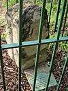 |
(#91000011) |
S. Jefferson St. south of the junction with Columbia Pike, in median strip 38°51′06″N 77°07′06″W / 38.851667°N 77.118333°W |
Arlington | part of the Boundary Markers of the Original District of Columbia MPS |
| 57 | Southwest No. 7 Boundary Marker of the Original District of Columbia | 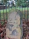 |
(#91000012) |
Behind 3101 S. Manchester St. 38°51′44″N 77°08′00″W / 38.862222°N 77.133333°W |
Arlington | part of the Boundary Markers of the Original District of Columbia MPS |
| 58 | Southwest No. 8 Boundary Marker of the Original District of Columbia | 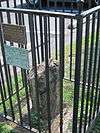 |
(#91000013) |
Junction of Wilson Blvd. and John Marshall Dr., behind apartment building 38°52′24″N 77°08′50″W / 38.873353°N 77.147122°W |
Arlington | part of the Boundary Markers of the Original District of Columbia MPS |
| 59 | Stratford Junior High School | 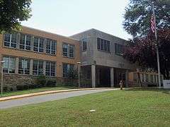 |
(#04000110) |
4100 Vacation Ln. 38°54′00″N 77°06′44″W / 38.9°N 77.112222°W |
Cherrydale | |
| 60 | Unitarian Universalist Church of Arlington | 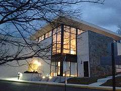 |
(#14000943) |
4444 Arlington Blvd. 38°52′06″N 77°06′27″W / 38.868352°N 77.107487°W |
Arlington | |
| 61 | US Post Office-Arlington | 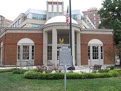 |
(#86000151) |
3118 N. Washington Blvd. 38°53′08″N 77°05′44″W / 38.885556°N 77.095556°W |
Clarendon | |
| 62 | Virginia Heights Historic District |  |
(#08000065) |
Bounded by 10th Pl. S., S. Frederick St. & S. George Mason Dr. 38°51′02″N 77°06′52″W / 38.850439°N 77.114569°W |
Arlington | part of the Historic Residential Suburbs in the United States, 1830-1960 MPS |
| 63 | Walter Reed Gardens Historic District |  |
(#03000451) |
2900-2906 13th St. S., 2900-2914 13th Rd. S., 1301-1319 S. Walter Reed Dr. 38°51′33″N 77°05′13″W / 38.859167°N 77.086944°W |
Arlington | part of the Garden Apartments, Apartment Houses and Apartment Complexes in Arlington County, Virginia MPS |
| 64 | Washington National Airport Terminal and South Hangar Line | 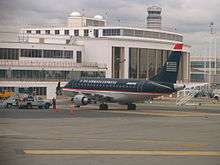 |
(#97001111) |
Thomas Ave. 38°50′50″N 77°02′41″W / 38.847222°N 77.044722°W |
Arlington | |
| 65 | Waverly Hills Historic District | .JPG) |
(#04000111) |
Roughly bounded by 20th Rd. N., N. Utah St, I-66, N. Glebe Rd. and N. Vermont St. 38°53′31″N 77°07′02″W / 38.891944°N 77.117222°W |
Arlington | |
| 66 | West Cornerstone | 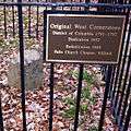 |
(#91000014) |
West side of Meridian St., south of the junction with Williamsburg Blvd. 38°53′33″N 77°10′21″W / 38.8925°N 77.1725°W |
Falls Church | part of the Boundary Markers of the Original District of Columbia MPS |
| 67 | Westover Historic District | 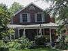 |
(#06000345) |
Bounded by McKinley Rd., N. Washington Blvd., N. 16th St., N. Jefferson St., N. 11th St. and N. Fairfax Dr. 38°52′58″N 77°08′11″W / 38.882775°N 77.136525°W |
Arlington | part of the Garden Apartments, Apartment Houses and Apartment Complexes in Arlington County, Virginia MPS |
| 68 | Earle Micajah Winslow House | 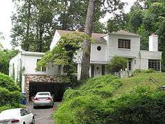 |
(#11000028) |
2333 N. Vernon St. 38°54′06″N 77°07′09″W / 38.901667°N 77.119167°W |
Arlington | part of the Streamline Modern Houses in Arlington County, Va 1936-1945 MPS |
See also
| Wikimedia Commons has media related to National Register of Historic Places in Arlington County, Virginia. |
- List of National Historic Landmarks in Virginia
- National Register of Historic Places listings in Virginia
- National Register of Historic Places listings in Falls Church, Virginia
- National Register of Historic Places listings in Alexandria, Virginia
References
- ↑ The latitude and longitude information provided in this table was derived originally from the National Register Information System, which has been found to be fairly accurate for about 99% of listings. For about 1% of NRIS original coordinates, experience has shown that one or both coordinates are typos or otherwise extremely far off; some corrections may have been made. A more subtle problem causes many locations to be off by up to 150 yards, depending on location in the country: most NRIS coordinates were derived from tracing out latitude and longitudes off of USGS topographical quadrant maps created under the North American Datum of 1927, which differs from the current, highly accurate WGS84 GPS system used by most on-line maps. Chicago is about right, but NRIS longitudes in Washington are higher by about 4.5 seconds, and are lower by about 2.0 seconds in Maine. Latitudes differ by about 1.0 second in Florida. Some locations in this table may have been corrected to current GPS standards.
- ↑ "National Register of Historic Places: Weekly List Actions". National Park Service, United States Department of the Interior. Retrieved on December 2, 2016.
- ↑ Numbers represent an ordering by significant words. Various colorings, defined here, differentiate National Historic Landmarks and historic districts from other NRHP buildings, structures, sites or objects.
- ↑ National Park Service (2008-04-24). "National Register Information System". National Register of Historic Places. National Park Service.
- ↑ The eight-digit number below each date is the number assigned to each location in the National Register Information System database, which can be viewed by clicking the number.


This article is issued from Wikipedia - version of the 11/26/2016. The text is available under the Creative Commons Attribution/Share Alike but additional terms may apply for the media files.