| [3] |
Name on the Register[4] |
Image |
Date listed[5] |
Location |
City or town |
Description |
|---|
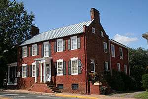
| 1 |
Ballard-Marshall House |
Upload image |
000000001988-10-27-0000October 27, 1988
(#88002138) |
158 E. Main St.
38°14′43″N 78°06′31″W / 38.245278°N 78.108611°W / 38.245278; -78.108611 (Ballard-Marshall House) |
Orange |
|
| 2 |
Barboursville |
|
000000001969-11-12-0000November 12, 1969
(#69000267) |
S of jct. of Rtes. 777 and 678
38°09′44″N 78°16′56″W / 38.162222°N 78.282222°W / 38.162222; -78.282222 (Barboursville) |
Barboursville |
|
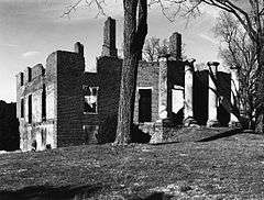
| 3 |
Berry Hill |
Upload image |
000000001980-05-07-0000May 7, 1980
(#80004208) |
S of Orange on VA 647
38°14′12″N 78°06′30″W / 38.236667°N 78.108333°W / 38.236667; -78.108333 (Berry Hill) |
Orange |
|
| 4 |
Black Meadow |
Upload image |
000000002005-11-16-0000November 16, 2005
(#05001262) |
17379 Wolf Trap Dr.
38°10′01″N 78°08′33″W / 38.166819°N 78.142422°W / 38.166819; -78.142422 (Black Meadow) |
Gordonsville |
|
| 5 |
Bloomsbury |
Upload image |
000000001992-02-27-0000February 27, 1992
(#92000044) |
Off VA 20 W of jct. with VA 600
38°15′23″N 78°03′33″W / 38.256389°N 78.059167°W / 38.256389; -78.059167 (Bloomsbury) |
Orange |
|
| 6 |
Burlington |
Upload image |
000000001994-01-11-0000January 11, 1994
(#93001458) |
6400 Constitution Hwy.
38°10′35″N 78°15′35″W / 38.176389°N 78.259722°W / 38.176389; -78.259722 (Burlington) |
Barboursville |
|
| 7 |
Chestnut Hill |
Upload image |
000000002009-06-11-0000June 11, 2009
(#09000417) |
236 Caroline St.
Coordinates missing |
Orange |
|
| 8 |
Exchange Hotel |
|
000000001973-08-14-0000August 14, 1973
(#73002046) |
S. Main St.
38°08′07″N 78°11′11″W / 38.135278°N 78.186389°W / 38.135278; -78.186389 (Exchange Hotel) |
Gordonsville |
|
| 9 |
Frascati |
Upload image |
000000001982-06-28-0000June 28, 1982
(#82004579) |
S of Somerset on VA 231
38°11′33″N 78°12′43″W / 38.1925°N 78.211944°W / 38.1925; -78.211944 (Frascati) |
Somerset |
|
| 10 |
Germanna Site |
Upload image |
000000001978-08-24-0000August 24, 1978
(#78003036) |
2062 Germanna Highway, Locust Grove
38°22′41″N 77°46′59″W / 38.378117°N 77.783185°W / 38.378117; -77.783185 (Germanna Site) |
|
|
| 11 |
Gordonsville Historic District |
Upload image |
000000001983-10-13-0000October 13, 1983
(#83004250) |
VA 15 and vicinity
38°08′09″N 78°11′15″W / 38.135833°N 78.1875°W / 38.135833; -78.1875 (Gordonsville Historic District) |
Gordonsville |
|
| 12 |
Greenwood |
Upload image |
000000001992-12-17-0000December 17, 1992
(#92001702) |
13011 Greenwood Rd.
38°13′42″N 78°08′19″W / 38.228333°N 78.138611°W / 38.228333; -78.138611 (Greenwood) |
Orange |
|
| 13 |
Grelen |
Upload image |
000000001998-02-13-0000February 13, 1998
(#98000049) |
15149 Grelen Dr.
38°17′01″N 78°07′00″W / 38.283611°N 78.116667°W / 38.283611; -78.116667 (Grelen) |
Orange |
|
| 14 |
Hampstead Farm Archeological District |
Upload image |
000000001984-08-16-0000August 16, 1984
(#84003559) |
Scuffletown Road (SR 609)
38°13′48″N 78°14′51″W / 38.230039°N 78.247379°W / 38.230039; -78.247379 (Hampstead Farm Archeological District) |
Barboursville |
|
| 15 |
Hare Forest Farm |
Upload image |
000000001992-01-28-0000January 28, 1992
(#91002016) |
VA 700 W of jct. with VA 615
38°17′12″N 78°04′46″W / 38.286667°N 78.079444°W / 38.286667; -78.079444 (Hare Forest Farm) |
Orange |
|
| 16 |
Lessland |
Upload image |
000000001999-08-05-0000August 5, 1999
(#99000965) |
4256 Bushy Mountain Rd.
38°20′37″N 77°58′21″W / 38.343611°N 77.9725°W / 38.343611; -77.9725 (Lessland) |
Culpeper |
|
| 17 |
Madison-Barbour Rural Historic District |
Upload image |
000000001991-01-17-0000January 17, 1991
(#90002115) |
Roughly bounded by US 15, the Rapidan R. and the Albemarle and Greene County lines
38°11′56″N 78°13′37″W / 38.198889°N 78.226944°W / 38.198889; -78.226944 (Madison-Barbour Rural Historic District) |
Barboursville |
|
| 18 |
Mayhurst |
|
000000001969-11-12-0000November 12, 1969
(#69000268) |
SW of jct. of Rte. 647 and U.S. 15
38°13′58″N 78°07′15″W / 38.232778°N 78.120833°W / 38.232778; -78.120833 (Mayhurst) |
Orange |
|
| 19 |
Montpelier |
|
000000001966-10-15-0000October 15, 1966
(#66000843) |
4 mi. W of Orange on VA 20
38°13′11″N 78°10′10″W / 38.219722°N 78.169444°W / 38.219722; -78.169444 (Montpelier) |
Orange |
Residence of President James Madison
|
| 20 |
Mount Sharon |
Upload image |
000000002013-09-09-0000September 9, 2013
(#13000710) |
19184 Mount Sharon Ln.
38°16′03″N 78°02′20″W / 38.267567°N 78.038786°W / 38.267567; -78.038786 (Mount Sharon) |
Orange |
|
| 21 |
Orange Commercial Historic District |
|
000000001999-01-21-0000January 21, 1999
(#98001651) |
Roughly along Madison and Main Sts.
38°14′40″N 78°06′42″W / 38.244444°N 78.111667°W / 38.244444; -78.111667 (Orange Commercial Historic District) |
Orange |
|
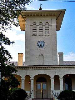
| 22 |
Orange County Courthouse |
|
000000001979-12-28-0000December 28, 1979
(#79003062) |
Madison Rd. and N. Main St.
38°14′42″N 78°06′43″W / 38.245°N 78.111944°W / 38.245; -78.111944 (Orange County Courthouse) |
Orange |
|
| 23 |
Orange High School |
Upload image |
000000002001-07-05-0000July 5, 2001
(#01000692) |
224 Belleview Ave.
38°15′02″N 78°06′55″W / 38.250556°N 78.115278°W / 38.250556; -78.115278 (Orange High School) |
Orange |
|
| 24 |
Orange Springs |
Upload image |
000000001992-02-27-0000February 27, 1992
(#90002134) |
VA 629 E of jct. with US 522
38°11′14″N 77°55′57″W / 38.187222°N 77.9325°W / 38.187222; -77.9325 (Orange Springs) |
Unionville |
|
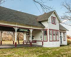
| 25 |
Rapidan Historic District |
|
000000001987-05-08-0000May 8, 1987
(#87000723) |
Jct. of VA 614, Virginia 615, and VA 673
38°18′35″N 78°04′08″W / 38.309722°N 78.068889°W / 38.309722; -78.068889 (Rapidan Historic District) |
Rapidan |
|
| 26 |
Rebel Hall |
Upload image |
000000002002-03-13-0000March 13, 2002
(#02000179) |
151 May-Fray Ave.
38°14′47″N 78°06′37″W / 38.246389°N 78.110278°W / 38.246389; -78.110278 (Rebel Hall) |
Orange |
|
| 27 |
Rocklands |
|
000000001982-09-23-0000September 23, 1982
(#82004578) |
N of Gordonsville on VA 231
38°10′36″N 78°11′16″W / 38.176667°N 78.187778°W / 38.176667; -78.187778 (Rocklands) |
Gordonsville |
|
| 28 |
Rockwood |
Upload image |
000000002001-07-05-0000July 5, 2001
(#01000695) |
12225 Chicken Mountain Rd.
38°12′31″N 78°09′40″W / 38.208611°N 78.161111°W / 38.208611; -78.161111 (Rockwood) |
Montpelier Station |
|
| 29 |
Somerset Christian Church |
Upload image |
000000001979-02-28-0000February 28, 1979
(#79003061) |
VA 20
38°13′34″N 78°13′29″W / 38.226111°N 78.224722°W / 38.226111; -78.224722 (Somerset Christian Church) |
Old Somerset |
|
| 30 |
St. Thomas Church |
Upload image |
000000001976-12-06-0000December 6, 1976
(#76002115) |
119 Caroline St.
38°14′37″N 78°06′49″W / 38.243611°N 78.113611°W / 38.243611; -78.113611 (St. Thomas Church) |
Orange |
|
| 31 |
Tetley |
Upload image |
000000001991-02-05-0000February 5, 1991
(#91000018) |
VA 64 E of jct. with VA 231
38°14′19″N 78°12′15″W / 38.238611°N 78.204167°W / 38.238611; -78.204167 (Tetley) |
Somerset |
|
| 32 |
Waddell Memorial Presbyterian Church |
Upload image |
000000001975-08-28-0000August 28, 1975
(#75002028) |
SE of Rapidan on VA 615
38°18′29″N 78°03′46″W / 38.308056°N 78.062778°W / 38.308056; -78.062778 (Waddell Memorial Presbyterian Church) |
Rapidan |
|
| 33 |
Willow Grove |
Upload image |
000000001979-05-07-0000May 7, 1979
(#79003063) |
2 mi. (3.2 km) NW of Orange on U.S. 15
38°16′23″N 78°07′57″W / 38.273056°N 78.1325°W / 38.273056; -78.1325 (Willow Grove) |
Madison Mills |
|
| 34 |
Williston |
Upload image |
000000002005-11-16-0000November 16, 2005
(#05001270) |
13430 Constitution Hwy.
38°14′23″N 78°08′07″W / 38.239722°N 78.135278°W / 38.239722; -78.135278 (Williston) |
Orange |
|


.jpg)