| [3] |
Name on the Register[4] |
Image |
Date listed[5] |
Location |
City or town |
Description |
|---|
| 1 |
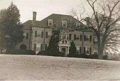
Berry Hill |
|
000000001969-11-25-0000November 25, 1969
(#69000246) |
S of jct. of Rtes. 659 and 682
36°41′55″N 78°56′39″W / 36.698611°N 78.944167°W / 36.698611; -78.944167 (Berry Hill) |
South Boston |
|
| 2 |
Black Walnut |
Upload image |
000000001991-10-29-0000October 29, 1991
(#91001597) |
VA 600, 850 ft. S of jct. with VA 778
36°51′47″N 78°43′22″W / 36.863056°N 78.722778°W / 36.863056; -78.722778 (Black Walnut) |
Clover |
|
| 3 |
Brandon Plantation |
Upload image |
000000001996-04-26-0000April 26, 1996
(#96000495) |
VA 697, 500 ft. W of jct. with VA 696
36°34′45″N 79°07′16″W / 36.579167°N 79.121111°W / 36.579167; -79.121111 (Brandon Plantation) |
Alton |
|
| 4 |
Brooklyn Store and Post Office |
Upload image |
000000001996-01-22-0000January 22, 1996
(#95001557) |
VA 659 N side, 0.1 mi. W of jct. with VA 820
36°40′37″N 79°09′04″W / 36.676944°N 79.151111°W / 36.676944; -79.151111 (Brooklyn Store and Post Office) |
Brooklyn |
|
| 5 |
Brooklyn Tobacco Factory |
Upload image |
000000001996-01-22-0000January 22, 1996
(#95001559) |
VA 659 N side, 0.25 mi. E of jct. with VA 820
36°40′46″N 79°08′43″W / 36.679444°N 79.145278°W / 36.679444; -79.145278 (Brooklyn Tobacco Factory) |
Brooklyn |
|
| 6 |
Buckshoal Farm |
Upload image |
000000001987-09-16-0000September 16, 1987
(#87001473) |
VA 737
36°38′33″N 78°46′15″W / 36.6425°N 78.770833°W / 36.6425; -78.770833 (Buckshoal Farm) |
Omega |
|
| 7 |
Carlbrook |
|
000000002000-05-26-0000May 26, 2000
(#00000556) |
VA 663, jct. VA 684
36°43′54″N 79°08′18″W / 36.731667°N 79.138333°W / 36.731667; -79.138333 (Carlbrook) |
Halifax |
|
| 8 |
Carter's Tavern |
Upload image |
000000001974-10-11-0000October 11, 1974
(#74002120) |
SE of Ingram
36°40′30″N 79°08′04″W / 36.675°N 79.134444°W / 36.675; -79.134444 (Carter's Tavern) |
Paces |
|
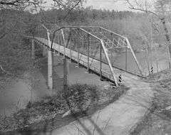
| 9 |
Clarkton Bridge |
|
000000002007-01-26-0000January 26, 2007
(#06000747) |
Clarkton Bridge Rd. over the Staunton River
36°58′40″N 78°53′49″W / 36.977778°N 78.896944°W / 36.977778; -78.896944 (Clarkton Bridge) |
Nathalie |
Extends into Charlotte County
|
| 10 |
Collins Ferry Historic District |
Upload image |
000000002012-11-28-0000November 28, 2012
(#12000986) |
McKeever Trail, & Bull Creek Rd.
37°02′15″N 79°02′35″W / 37.0375°N 79.043°W / 37.0375; -79.043 (Collins Ferry Historic District) |
Nathalie |
|
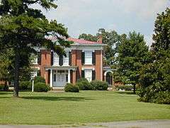
| 11 |
The Cove |
Upload image |
000000002006-05-11-0000May 11, 2006
(#06000407) |
5059 Cove Rd.
36°58′58″N 78°44′51″W / 36.982778°N 78.7475°W / 36.982778; -78.7475 (The Cove) |
Harrisburg |
|
| 12 |
DeJarnette's Tavern |
|
000000002007-05-02-0000May 2, 2007
(#07000398) |
4080 Stagecoach Rd.
37°00′47″N 79°00′22″W / 37.013056°N 79.006111°W / 37.013056; -79.006111 (DeJarnette's Tavern) |
Nathalie |
Late 18th century stagecoach station and tavern.
|
| 13 |
E. L. Evans House |
|
000000002008-05-08-0000May 8, 2008
(#08000388) |
1204 Washington Ave.
36°42′15″N 78°54′01″W / 36.704256°N 78.900233°W / 36.704256; -78.900233 (E. L. Evans House) |
South Boston |
|
| 14 |
Fourqurean House |
Upload image |
000000001980-05-06-0000May 6, 1980
(#80004192) |
2.4 mi. SW of South Boston
36°39′21″N 78°56′27″W / 36.655833°N 78.940833°W / 36.655833; -78.940833 (Fourqurean House) |
South Boston |
|
| 15 |
Glennmary |
Upload image |
000000001979-02-01-0000February 1, 1979
(#79003043) |
SW of South Boston on U.S. 58
36°40′42″N 78°56′00″W / 36.678333°N 78.933333°W / 36.678333; -78.933333 (Glennmary) |
South Boston |
|
| 16 |
Halifax County Courthouse |
|
000000001982-09-16-0000September 16, 1982
(#82004563) |
Jct. US 360 and US 501
36°45′56″N 78°55′46″W / 36.765556°N 78.929444°W / 36.765556; -78.929444 (Halifax County Courthouse) |
Halifax |
|
| 17 |
Indian Jim's Cave |
Upload image |
000000001982-08-26-0000August 26, 1982
(#82004562) |
Address Restricted
|
Brookneal |
|
| 18 |
Mountain Road Historic District |
Upload image |
000000001983-10-06-0000October 6, 1983
(#83004245) |
Roughly Mountain Rd. from Mimosa Dr. to Academy St.
36°45′59″N 78°56′07″W / 36.766389°N 78.935278°W / 36.766389; -78.935278 (Mountain Road Historic District) |
Halifax |
Boundary increase recorded August 24, 2015.
|
| 19 |
Old Providence Presbyterian Church |
Upload image |
000000001988-07-07-0000July 7, 1988
(#88001013) |
VA 624
36°56′15″N 78°49′11″W / 36.9375°N 78.819722°W / 36.9375; -78.819722 (Old Providence Presbyterian Church) |
Providence |
|
| 20 |
Pleasant Grove |
Upload image |
000000001999-08-05-0000August 5, 1999
(#99000966) |
Deer Run Rd.
36°43′14″N 79°02′55″W / 36.720556°N 79.048611°W / 36.720556; -79.048611 (Pleasant Grove) |
Halifax |
|
| 21 |
Redfield |
|
000000001978-09-20-0000September 20, 1978
(#78003020) |
3 mi. SE of Oak Level on VA 683
36°42′03″N 79°04′41″W / 36.700833°N 79.078056°W / 36.700833; -79.078056 (Redfield) |
Oak Level |
|
| 22 |
Reedy Creek Site |
Upload image |
000000001978-04-26-0000April 26, 1978
(#78003187) |
Address Restricted
|
South Boston |
|
| 23 |
Seaton |
Upload image |
000000001980-05-19-0000May 19, 1980
(#80004193) |
N of South Boston on U.S. 501
36°44′41″N 78°55′24″W / 36.744722°N 78.923333°W / 36.744722; -78.923333 (Seaton) |
South Boston |
|
| 24 |
South Boston Historic District |
|
000000001986-09-26-0000September 26, 1986
(#86002471) |
Along Railroad Ave., Ferry, Factory, and Main Sts., Wilborn Ave., N. Main St., Washington and Peach Aves., and Jeffress; also neighborhoods of Marshall Ave., New Brick Warehouse, Mizpah Church, N. Main St.
36°41′57″N 78°54′10″W / 36.699167°N 78.902778°W / 36.699167; -78.902778 (South Boston Historic District) |
South Boston |
Second set of boundaries represents a boundary increase of 000000002009-06-11-0000June 11, 2009
|
| 25 |
Staunton River Bridge Fortification |
Upload image |
000000002014-11-19-0000November 19, 2014
(#04000577) |
Address Restricted
36°52′53″N 78°42′05″W / 36.8815°N 78.7015°W / 36.8815; -78.7015 (Staunton River Bridge Fortification) |
Randolph |
In or near Staunton River Battlefield State Park.
|
| 26 |
Staunton River State Park Historic District |
|
000000002007-05-04-0000May 4, 2007
(#07000402) |
1170 Staunton Trail
36°41′57″N 78°40′03″W / 36.699219°N 78.667628°W / 36.699219; -78.667628 (Staunton River State Park Historic District) |
Scottsburg |
|
| 27 |
Tarover |
Upload image |
000000001978-09-20-0000September 20, 1978
(#78003021) |
West of South Boston on VA 659
36°42′02″N 78°57′53″W / 36.700556°N 78.964722°W / 36.700556; -78.964722 (Tarover) |
South Boston |
|
| 28 |
Dr. Richard Thornton House |
Upload image |
000000002012-11-28-0000November 28, 2012
(#12000987) |
Golden Leaf and Tobacco Rds.
36°58′38″N 79°01′58″W / 36.97723°N 79.0328°W / 36.97723; -79.0328 (Dr. Richard Thornton House) |
Nathalie |
|
| 29 |
Town of Halifax Court House Historic District |
|
000000002011-01-28-0000January 28, 2011
(#10001187) |
Main St., Cemetery St., Prizery St., Edmunds Boulevard, Mary Bethune St., Cowford Rd., Maple Ave., Church St., Cary St.
36°45′58″N 78°55′43″W / 36.766111°N 78.928611°W / 36.766111; -78.928611 (Town of Halifax Court House Historic District) |
Halifax |
|
.jpg)

.jpg)
.jpg)
.jpg)
.jpg)
.jpg)

