National Register of Historic Places listings in Bath County, Virginia
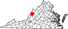
Location of Bath County in Virginia
This is a list of the National Register of Historic Places listings in Bath County, Virginia.
This is intended to be a complete list of the properties and districts on the National Register of Historic Places in Bath County, Virginia, United States. The locations of National Register properties and districts for which the latitude and longitude coordinates are included below, may be seen in a Google map.[1]
There are 20 properties and districts listed on the National Register in the county, including 1 National Historic Landmark.
- This National Park Service list is complete through NPS recent listings posted December 2, 2016.[2]
Current listings
| [3] |
Name on the Register[4] |
Image |
Date listed[5] |
Location |
City or town |
Description |
|---|
| 1 |
Ashwood School |
Upload image |
000000002016-07-28-0000July 28, 2016
(#16000484) |
5604 Sam Snead Hwy.
37°58′23″N 79°51′00″W / 37.973011°N 79.849947°W / 37.973011; -79.849947 (Ashwood School) |
Hot Springs |
|
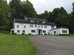
| 2 |
Barton Lodge |
Upload image |
000000002013-12-24-0000December 24, 2013
(#13000984) |
373 French's Hill Dr.
37°59′48″N 79°50′04″W / 37.996593°N 79.834470°W / 37.996593; -79.834470 (Barton Lodge) |
Hot Springs |
|
| 3 |
Camp Alkulana Historic District |
Upload image |
000000002015-04-06-0000April 6, 2015
(#15000135) |
111 Alkulana Camp Rd.
37°59′32″N 79°37′11″W / 37.9922°N 79.6196°W / 37.9922; -79.6196 (Camp Alkulana Historic District) |
Millboro Springs |
|
| 4 |
Camp Mont Shenandoah Historic District |
Upload image |
000000002015-04-06-0000April 6, 2015
(#15000136) |
218 Mont Shenandoah Ln.
37°59′13″N 79°38′44″W / 37.987°N 79.6456°W / 37.987; -79.6456 (Camp Mont Shenandoah Historic District) |
Millboro Springs |
|
| 5 |
Douthat State Park Historic District |
|
000000001986-09-20-0000September 20, 1986
(#86002183) |
State Route 629
37°53′13″N 79°48′36″W / 37.886944°N 79.81°W / 37.886944; -79.81 (Douthat State Park Historic District) |
Millboro |
|
| 6 |
Garth Newel |
|
000000002013-06-19-0000June 19, 2013
(#13000402) |
447 Garth Newel Ln.
38°01′34″N 79°48′01″W / 38.02623°N 79.80040°W / 38.02623; -79.80040 (Garth Newel) |
Hot Springs |
|
| 7 |
Hidden Valley |
Upload image |
000000001970-02-26-0000February 26, 1970
(#70000784) |
North of Bacova near the junction of State Routes 39 and 621 in the George Washington National Forest
38°06′23″N 79°48′53″W / 38.106389°N 79.814722°W / 38.106389; -79.814722 (Hidden Valley) |
Bacova |
|
| 8 |
Hidden Valley Rock Shelter (44BA31) |
Upload image |
000000001986-07-22-0000July 22, 1986
(#86001945) |
Address Restricted
|
Warm Springs |
|
| 9 |
Homestead Dairy Barns |
Upload image |
000000002007-02-13-0000February 13, 2007
(#07000051) |
U.S. Route 220
38°03′02″N 79°46′59″W / 38.050525°N 79.783167°W / 38.050525; -79.783167 (Homestead Dairy Barns) |
Warm Springs |
|
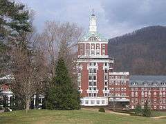
| 10 |
The Homestead |
|
000000001984-05-03-0000May 3, 1984
(#84003494) |
U.S. Route 220
37°59′49″N 79°49′50″W / 37.996944°N 79.830556°W / 37.996944; -79.830556 (The Homestead) |
Hot Springs |
|
| 11 |
Millboro School |
Upload image |
000000002004-01-16-0000January 16, 2004
(#03001439) |
Junction of State Routes 668 (High St.) and 633 (Main St.)
37°58′42″N 79°36′12″W / 37.978333°N 79.603333°W / 37.978333; -79.603333 (Millboro School) |
Millboro |
|
| 12 |
Mustoe House |
Upload image |
000000002002-04-12-0000April 12, 2002
(#02000363) |
Rural 2, Box 211
37°55′16″N 79°53′27″W / 37.921111°N 79.890833°W / 37.921111; -79.890833 (Mustoe House) |
Hot Springs |
|
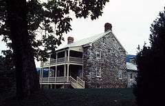
| 13 |
Oakley Farm |
Upload image |
000000002007-08-08-0000August 8, 2007
(#07000803) |
11865 Sam Snead Highway (U.S. Route 220)
38°02′33″N 79°47′23″W / 38.042589°N 79.789597°W / 38.042589; -79.789597 (Oakley Farm) |
Warm Springs |
|
| 14 |
Old Stone House |
|
000000001983-02-10-0000February 10, 1983
(#83003262) |
Southwest of Milboro Springs on State Route 664
37°55′31″N 79°43′53″W / 37.925278°N 79.731389°W / 37.925278; -79.731389 (Old Stone House) |
Millboro Springs |
|
| 15 |
Switchback School |
Upload image |
000000002013-12-24-0000December 24, 2013
(#13000985) |
210 Pinehurst Heights Rd.
38°00′42″N 79°50′34″W / 38.011539°N 79.842787°W / 38.011539; -79.842787 (Switchback School) |
Hot Springs |
|
| 16 |
Three Hills |
Upload image |
000000002013-12-24-0000December 24, 2013
(#13000986) |
348 Three Hills Ln.
38°02′44″N 79°46′57″W / 38.045632°N 79.782468°W / 38.045632; -79.782468 (Three Hills) |
Warm Springs |
|
| 17 |
Warm Springs Bathhouses |
|
000000001969-10-08-0000October 8, 1969
(#69000222) |
Northeast of Warm Springs off U.S. Route 220
38°03′13″N 79°46′51″W / 38.053611°N 79.780833°W / 38.053611; -79.780833 (Warm Springs Bathhouses) |
Warm Springs |
Also known as Jefferson Pools
|
| 18 |
Warm Springs Mill |
Upload image |
000000001989-09-11-0000September 11, 1989
(#88001448) |
Eastern side of State Route 645
38°02′51″N 79°47′25″W / 38.0475°N 79.790278°W / 38.0475; -79.790278 (Warm Springs Mill) |
Warm Springs |
|
| 19 |
John Wesley Methodist Episcopal Church and Cemetery |
Upload image |
000000002013-12-24-0000December 24, 2013
(#13000987) |
212 W. Warm Springs
38°03′34″N 79°48′21″W / 38.0595536°N 79.8057803°W / 38.0595536; -79.8057803 (John Wesley Methodist Episcopal Church and Cemetery) |
West Warm Springs |
|
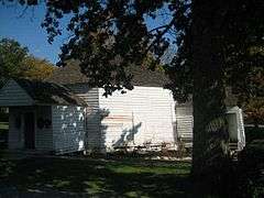
| 20 |
The Yard |
Upload image |
000000002007-02-13-0000February 13, 2007
(#07000050) |
381 Old Greenhouse Rd.
37°59′31″N 79°50′08″W / 37.992039°N 79.835447°W / 37.992039; -79.835447 (The Yard) |
Hot Springs |
|
See also
References
- ↑ The latitude and longitude information provided in this table was derived originally from the National Register Information System, which has been found to be fairly accurate for about 99% of listings. For about 1% of NRIS original coordinates, experience has shown that one or both coordinates are typos or otherwise extremely far off; some corrections may have been made. A more subtle problem causes many locations to be off by up to 150 yards, depending on location in the country: most NRIS coordinates were derived from tracing out latitude and longitudes off of USGS topographical quadrant maps created under the North American Datum of 1927, which differs from the current, highly accurate WGS84 GPS system used by most on-line maps. Chicago is about right, but NRIS longitudes in Washington are higher by about 4.5 seconds, and are lower by about 2.0 seconds in Maine. Latitudes differ by about 1.0 second in Florida. Some locations in this table may have been corrected to current GPS standards.
- ↑ "National Register of Historic Places: Weekly List Actions". National Park Service, United States Department of the Interior. Retrieved on December 2, 2016.
- ↑ Numbers represent an ordering by significant words. Various colorings, defined here, differentiate National Historic Landmarks and historic districts from other NRHP buildings, structures, sites or objects.
- ↑ National Park Service (2009-03-13). "National Register Information System". National Register of Historic Places. National Park Service.
- ↑ The eight-digit number below each date is the number assigned to each location in the National Register Information System database, which can be viewed by clicking the number.
|
|---|
|
Lists
by county | | |
|---|
|
Lists
by city | |
|---|
|
| Other lists | |
|---|
|
|