Fort Norfolk (Norfolk, Virginia)
|
Fort Norfolk | |
|
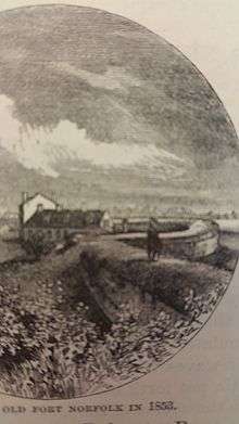
Plan of Fort Norfolk in 1860 | |
  | |
| Location | 803 Front St., Norfolk, Virginia |
|---|---|
| Coordinates | 36°51′24″N 76°18′24″W / 36.85667°N 76.30667°WCoordinates: 36°51′24″N 76°18′24″W / 36.85667°N 76.30667°W |
| Area | 4 acres (1.6 ha) |
| Built | 1795 |
| NRHP Reference # | 76002225[1] |
| VLR # | 122-0007 |
| Significant dates | |
| Added to NRHP | October 29, 1976 |
| Designated VLR | December 16, 1975[2] |


Fort Norfolk is a historic fort and national historic district located at Norfolk, Virginia. With the original buildings having been built between 1795 and 1809, the fort encompasses 11 contributing buildings which include: main gate, guardhouse, officers' quarters, powder magazine, and carpenter's shop. Fort Norfolk is the last remaining fortification of President George Washington’s 18th Century harbor defenses. It has served as the district office for the U. S. Army Engineer District, Norfolk since 1923.[4]
It was listed on the National Register of Historic Places in 1976.[1] Later it became a Virginia Landmark in 2013. Now it is preserved as a historic fort and is open to the public during the summer.
Origin
Although private property at the time, the site of Fort Norfolk was first fortified by citizens of Norfolk during the U.S. Revolutionary War in order provide harbor defense.[5] The fort is located at a point where the Elizabeth River narrows and was used in conjunction with Fort Nelson on the opposite bank of the river in Portsmouth. This was done with the aims to provide a cross fire for any ships that would attempt to bombard and/or conduct an amphibious assault on Norfolk or Portsmouth. Ultimately this failed as these positions were too weak to prevent a naval bombardment on Norfolk, later known as the Burning of Norfolk, by Lord Dunmore on January 1, 1776.
Construction
Congress authorized President George Washington to build defensive fortifications along what they determined the "Maritime Frontier" in order to defend American harbors. In 1795, construction began on Fort Norfolk. It was originally built with earthen walls and utilized either wooden or brick supports. The northern, eastern, and southern facing sides are designed after a Vauban style star fort. The western side resembles a half moon shape and is called a semicircular bastion. This was an experimental design and the purpose was to maximize the number of cannon overlooking the river. While the design of a semicircular bastion is vulnerable to a land assault, this section of the fort is on the eastern bank of the Elizabeth River; therefore, it is not susceptible to a land assault.
War of 1812
During 1810, in anticipation for another war with Britain, the defensive sea wall was reinforced to reach 12 feet high and 20 feet thick. All exterior walls that were not originally built of brick and masonry were then replaced with brick and masonry. The eastern and northern inland facing sides continued to mimick a star fort. A ravelin was added on the east side of the fort to further reinforce the fort in preparation of a land assault. Additionally, this provided needed protection to the Officers' Quarters building, (used as the Shell House during the Civil War) which also served as the center part the eastern perimeter wall. The armament composed of nine eighteen pound cannons with large quantities of gunpowder, shot, and shell. Although Fort Norfolk itself never saw conflict, it was in operation during the War of 1812. An elongated chain was stretched from Fort Norfolk to Fort Nelson in order to prevent the British Fleet from attacking Gosport Shipyard, Norfolk, and/or Portsmouth. During the War of 1812, soldiers stationed at Fort Norfolk were sent to reinforce the defense at Craney Island and took part in the Battle of Craney Island.[5]
Following the war, the construction of Fort Monroe made Fort Norfolk obsolete. Located outside of what was then city limits, the fort remained standing but it ceased to be occupied.
Civil War
Prior to the U.S. Civil War, a powder magazine was added and used to assemble, store, and load munitions for ships built or repaired at what was then Gosport Shipyard, now known as Norfolk Naval Shipyard. Later steps were taken to defend Norfolk from seceding armies. Fort Norfolk was again operational and a battery was assigned to Fort Norfolk.
When Virginia seceded in 1861, the Union Army was forced to abandon both Norfolk and Fort Norfolk. The Confederate Army occupied Norfolk and Portsmouth; therefore, occupying both the fort and Gosport Shipyard. Fort Norfolk was then used to by the Confederate Army to defend Gosport Shipyard. The fort’s newly added powder magazine also supplied Confederate ships who tried to break the Union blockade on Hampton Roads. The most famous of these encounters, being the Battle of Hampton Roads between the USS Monitor and the CSS Virginia, often referred to as the Merrimac(k) because it was previously the USS Merrimack.
The Union Army reoccupied Fort Norfolk in 1862 after General John E. Wool landed at Willoughby and marched on the city Norfolk.[5] This caused the Confederates to evacuate both the fort and the city resulting in Norfolk’s surrender. For the remainder of the Civil War, under Union occupation, Fort Norfolk was used to imprison captured Confederate blockade runners.
Army Corps of Engineers
The Army Corps of Engineers occupied Fort Norfolk in 1923 and used the Fort as offices to plan engineering works for the east coast.[5] During World War II, the fort continued to be used as offices for the Army Corps of Engineers, existing brick structures were renovated, and an additional structure for office use was built. In 1983, the new Army Corps of Engineers building was constructed next to Fort Norfolk but they still retain the fort today. However, in collaboration with the Army Corps of Engineers, the Norfolk Historical Society began making restorations and giving tours of the fort in 1991.
Timeline
- 1776 Commonwealth of Virginia establishes Fort Norfolk
- 1794 Congress authorizes President George Washington to construct a number of forts to protect U.S. harbors, including Fort Norfolk.
- 1810 Brick perimeter walls and most structures were built.
- 1813 22 June, Soldiers take part in the battle of Craney Island.
- 1834 Construction of Fort Monroe is completed and Government abandons Fort Norfolk.
- 1850 U.S. Navy converts Fort into ammunition depot.
- 1856 The large magazine is completed.
- 1861 Confederate General Taliaferro takes command of the fort and sets up a battery as the Civil War is declared.
- 1862 General Wool landed at Willoughby after the Confederate evacuation of Norfolk. Union army occupies Fort Norfolk and uses it as a Federal prison.
- 1863 Returned to U.S. Navy for ammunition storage.
- 1880 Navy vacates the fort.
- 1921 Army Corps of Engineers occupies the fort.
- 1983 Army Corps of Engineers moves to new building.
- 1992 Fort Norfolk opens to the public.
(Dates for timeline found at https://archive.org/stream/fortnorfolknorfo00norf#page/n1/mode/2up)
References
- 1 2 National Park Service (2010-07-09). "National Register Information System". National Register of Historic Places. National Park Service.
- ↑ "Virginia Landmarks Register". Virginia Department of Historic Resources. Retrieved 19 March 2013.
- 1 2 Lossing, Benson (1868). The Pictorial Field-Book of the War of 1812. Harper & Brothers, Publishers. p. 668.
- ↑ Virginia Historic Landmarks Commission Staff (December 1975). "National Register of Historic Places Inventory/Nomination: Fort Norfolk" (PDF). Virginia Department of Historic Resources. and Accompanying photo
- 1 2 3 4 Virginia Historic Landmarks Commission Staff (December 1975). "National Register of Historic Places Inventory/Nomination: Fort Norfolk" (PDF). Virginia Department of Historic Resources.
External links
- U. S. Army Engineer District, Norfolk website
- Norfolk Historical Society’s webpage on Fort Norfolk
- National Register Of Historic Places Nomination Form
- Norfolk Historical Society’s Virtual Tour
- Youtube link - Fort Norfolk, From Humble Beginnings
- Youtube link - French Influence On Forts Of The American Revolution

