Kemmangundi
| Kemmannundi ಕೆಮ್ಮಣ್ಣುಗುಂಡಿ Kemmannugundi | |
|---|---|
| village | |
|
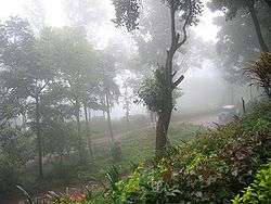
Foggy day at Kemmangundi | |
 Kemmannundi Location in Karnataka, India | |
| Coordinates: 13°32′49″N 75°45′29″E / 13.547°N 75.758°ECoordinates: 13°32′49″N 75°45′29″E / 13.547°N 75.758°E | |
| Country |
|
| State | Karnataka |
| District | Chikkamagaluru |
| Elevation | 1,434 m (4,705 ft) |
| Languages | |
| • Official | Kannada |
| Time zone | IST (UTC+5:30) |
| PIN | 577 129 |
| Telephone code | 08261 |
| Vehicle registration | KA-18 |
Kemmannugundi (Kannada: ಕೆಮ್ಮಣ್ಣುಗುಂಡಿ) is a hill station in Tarikere taluk of Chikkamagaluru district in the state of Karnataka, India. It is 1434m above sea level.[1] This was the summer retreat of Krishnaraja Wodeyar IV and as a mark of respect to the king, it is also known as Sri Krishnarajendra Hill Station. The station is ringed by the Baba Budan Giri Range, with cascades, mountain streams, and lush vegetation, Kemmangundi’s has ornamental gardens and mountains and valleys views. There is a spectacular sunset view from the Raj Bhavan.
History
Kemmannugundi (or Kemmannagundi) derives its name from three Kannada words - Kempu (red), mannu (soil) and gundi (pit).
Kemmannugundi was established as the summer retreat of Krishnaraja Wodeyar IV. He later donated this resort to the Government of Karnataka. The Horticultural Department of Karnataka now develops and maintains the resort and its surroundings.
Landmarks

Z point
Z point is a vantage point at Kemmangundi and can be reached by a steep uphill trek of about 45 minutes from Raj Bhavan and is another place from which to view the sunrise. Shanthi Falls near Kemmangundi can be visited.
Rose garden
Rose garden is a garden of roses maintained by the Horticultural Department of Karnataka. Many varieties of roses are cultivated there.
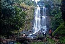
Hebbe Falls
A downhill trek of about 8 km from Raj Bhavan takes one to Hebbe Falls where water streams down from a height of 168 meters in two stages to form Dodda Hebbe (Big Falls) and Chikka Hebbe (Small Falls). Jeeps are available from one particular point to Hebbe falls and they charge around INR 700 to 1200 (for an up and down trip depending on the no of people). Hebbe Falls is now a Restricted Area and hence this is no longer a Tourist spot, since this place has attracted the Tigers nearby.
Kallathi falls
Kallathi falls is about 10 km. from Kemmangundi. On the road from Kemmangundi to Tarikere, a deviation takes one to Kallathi falls. It is also known as Kallathigiri falls and Kalahasthi falls. Water cascades from a height of 122 metres and the temple here is attributed to times of the Vijayanagar empire. According to a local legend, this place is associated with the Hindu sage, Agastya.
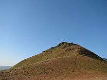
Mullayanagiri
Mullayanagiri is the tallest peak in Karnataka and is famous for the temple perched on the peak. Though the route to Kemmangudi through Mullayanagiri is scenic and beautiful, the roads can be narrow and bad.
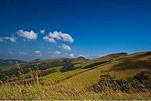
Baba Budan giri
Baba Budangiri is second tallest peak in Karnataka. It has a darga and Datta Peetha religious places. Manikyadhara falls and Galikere lake are nearby.
Climate
Kemmanagundi has a Sub-Tropical Highland climate influenced by Monsoon.it has three seasons Winter(Nov-Feb temp 24-12) followed by Summer(Mar-May 28-16) and Monsoon(June-Oct 22-15) and has cool climate throughout the year than most cities in the sub-continent.December is the coldest month with mean temperature of 17 and April is the hottest with a mean of 22.2. Most precipitation falls in July, with an average of 591 mm February is the driest month.
| Climate data for Kemmanagundi | |||||||||||||
|---|---|---|---|---|---|---|---|---|---|---|---|---|---|
| Month | Jan | Feb | Mar | Apr | May | Jun | Jul | Aug | Sep | Oct | Nov | Dec | Year |
| Average high °C (°F) | 24.0 (75.2) |
26.2 (79.2) |
28.1 (82.6) |
28.4 (83.1) |
27.5 (81.5) |
21.4 (70.5) |
19.5 (67.1) |
21.0 (69.8) |
22.3 (72.1) |
23.0 (73.4) |
23.0 (73.4) |
23.2 (73.8) |
23.97 (75.14) |
| Average low °C (°F) | 11.3 (52.3) |
13.2 (55.8) |
15.0 (59) |
16.0 (60.8) |
16.5 (61.7) |
15.8 (60.4) |
15.0 (59) |
15.6 (60.1) |
15.7 (60.3) |
14.0 (57.2) |
13.7 (56.7) |
11.4 (52.5) |
14.43 (57.98) |
| Average rainfall mm (inches) | 1.6 (0.063) |
0.6 (0.024) |
11.0 (0.433) |
66.0 (2.598) |
137.2 (5.402) |
260.1 (10.24) |
594.1 (23.39) |
441.5 (17.382) |
234.0 (9.213) |
227.6 (8.961) |
69.2 (2.724) |
13.5 (0.531) |
2,056.4 (80.961) |
| Source: http://en.climate-data.org/location/796942/ | |||||||||||||
Transport
Road
Kemmannugundi is 53 km from Chikkamagaluru and 17 km from Lingadahalli by road. The nearest National Highways, NH-206 or NH-48, connect to Bangalore. There is another route via Mullayyanagiri, a scenic drive. If you are dependent only on public transport then you can catch a private bus from Lingadahalli at 9.30am and the same bus (last bus) comes at Kemmanagundi at 4.30pm goes to Birur via Lingadahalli.
Rail
The nearest railway station is 33 km away at Birur& Kadur.
Air
The nearest airports are at Mangalore (150 km) and Bangalore.
Stay
The first choice of accommodation for most visitors to Kemmangundi Karnataka is the Horticulture Department Guest House (known as Raj Bhavan), which provides a number of cottages. This is a budget dormitory-type accommodation with a double room costing less than Rs.300/-. However, be warned: most visitors are unhappy with the facilities, with unwashed bed sheets and limited (cold) food. You need to book accommodation at the Horticulture Department Guest House well in advance and it is very rare that you will find a cottage vacant otherwise. Contact details given below: Horticulture Department, Lalbagh, Bangalore-560004 Telephone: 080-26579231 (Between March 15 to July 15) OR Special Officer Krishnarajendra Hill Station, Kemmannagundi Post, Tarikere Taluk, Chickmagalur district. Telephone: 08261-237126 (Between July 16 to March 14)
There is also a Horticulture Department Guest House in Kallathi village, where the famous Kallathi waterfalls are located. Phone Number of Horticulture Department Guest House Kallathi: 08262-235334. Before calling to Kallathi Guest House, please contact special officer for the availability of rooms at 94810-13320.
See also
| Wikimedia Commons has media related to Kemmangundi. |
- Nandi Hills
- Malnad
- Chamundi Hills
- Kemmangundi
- Kudremukh
- Nilgiris (mountains)
- Himalayas
- Kodaikanal
- Devaramane