Agastya Mala
| Agasthyarkoodam അഗസ്ത്യമല | |
|---|---|
| அகத்திய மலை | |
|
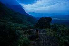
A view of Agasthyarkoodam from the base | |
| Highest point | |
| Elevation | 1,868 m (6,129 ft) |
| Coordinates | 8°37′N 77°15′E / 8.617°N 77.250°ECoordinates: 8°37′N 77°15′E / 8.617°N 77.250°E |
| Naming | |
| Translation | Hill of Agasthya (Malayalam / Tamil) |
| Geography | |
| Parent range | Western Ghats |
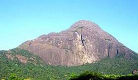
Agasthyarkoodam is a 1,868-metre (6,129 ft)-tall peak within Neyyar Wildlife Sanctuary, Kerala in the Western Ghats of South India. The peak lies inside Kerala near the border with Tamilnadu.[1] This peak is a part of the Agasthyamala Biosphere Reserve which lies on the border between the Indian states of Kerala (in Kollam and Thiruvananthapuram district) and Tamil Nadu (in Kanyakumari district, Tirunelveli district). The perennial Thamirabarani River originates from the eastern side of the range and flows into the Tirunelveli district of Tamil Nadu.
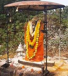
Agasthyarkoodam is a pilgrimage centre for devotees of the Hindu sage Agastya, who is considered to be one of the seven rishis (Saptarishi) of Hindu Puranas. The Tamil language is considered to be a boon from Agasthya. There is a full-sized statue of Agathiyar at the top of the peak and the devotees can offer pujas themselves.
Agasthyamala Biosphere Reserve is among 20 new sites added by UNESCO to its World Network of Biosphere Reserves in March 2016. The International Co-ordinating Council added the new sites during a two-day meeting on March 19, 2016 in Lima, bringing the total number of biosphere reserves to 669 sites in 120 countries, including 16 transboundary sites.[2]
Geography
Agasthyarkoodam is 32 km from Neyyar Dam and 23 km from Bonacaud, near Ponmudi. The major city and airport nearest to Agasthyarkoodam is Thiruvananthapuram (Trivandrum) and its Trivandrum International Airport, around 61 km away. The nearest railway station is Ambasamudram, Tirunelveli District, Tamil Nadu. The trekking path, nearly 35 km, is from Bonacaud.
Kalakkad Mundanthurai Tiger Reserve is part of the Agasthyarkoodam range. Part of the peak can be seen from the Upper Kodayar region.

Other major rivers which originate from the mountain are the Karamana River, which flows through the Thiruvananthapuram district and is the major source of drinking water to the city, and the Neyyar River (also in the Thiruvananthapuram district).
Trekking routes
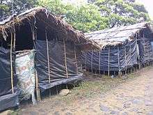
The peak of Agasthyarkoodam[3] can be reached only by trekking up to it. Trekking[4] is allowed based on strict guidelines and is open to pilgrims during January to mid-March. Trekking passes are issued by Kerala Forest Department from the district office at Trivandrum.[5][6] The trekking route starts from Bonacaud. The route "Neyyar-Agasthyakoodam" is not open to the public.
Vehicles reach only till Bonacaud which is around 50 km from Thiruvananthapuram. The trek to the peak is 28 km long from Bonacaud and requires two days. The first part of the trek can be started from the base station Bonacaud in the early morning and is 20 km through the forest to the camp. Elephants and wild bulls are in abundance in this part especially in the evenings. The final part ie the 8km long trek can be done from the camp to the top of Agathyakoodam mountain on the second day.
Vegetation
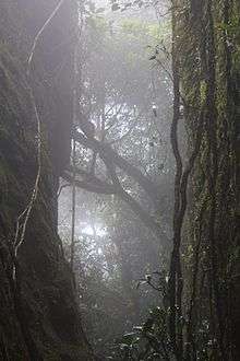
The lower elevations of this peak are known for their abundance of rare herbs and medicinal plants. Around 2,000 medicinal plants used in Ayurvedic treatments are found here. Europeans, particularly those from England, were the first to establish tea gardens around the base stations of the mountain at Brimore, Bonacaud, and Ponmudi.
The Agasthyamala Biosphere Reserve harbours rare flora and fauna. Tourists are permitted to the area only with permission from the forest department of Kerala. Annual trekking passes to the peak are issued from the forest department during January–February only.
Important places
Manjolai Hills
Between elevations ranging from 1000 to 1500 metres, the Manjolai area is set deep within the Western Ghats within the Kalakkad Mundanthurai Tiger Reserve in the Tirunelveli District. Located on top of the Manimuthar Dam and the Manimuthar Water Falls, the Manjolai area has tea plantations, small settlements around the tea plantations, Upper Kodaiyar Dam, and a windy view point called Kuthiravetti.
The tea plantations and the whole of Manjolai Estates are operated by the Bombay Burmah Trading Corporation Ltd on forest lands leased by the singampatti zamin. There are three tea estates in the Manjolai area — Manjolai Estate, Manimutharu Estate, and Oothu Estate. The estates are on elevations ranging between 2,300 and 4,200 feet (701 and 1,280 m). The estates, road, and the settlements in the Manjolai area are managed by the Bombay Burmah Trading Corporation Ltd.
See also
- Agasthyamala Biosphere Reserve
- Indian Council of Forestry Research and Education
- Thamirabarani River
- Tirunelveli
- Papanasam
- Anamudi - Highest peak in Western Ghats
- Tourism in Thiruvananthapuram
References
[7]; -webkit-column-width: [8] [9]; column-width: [10] [11]; list-style-type: decimal;">
- ↑ Refer Google Earth.
- ↑ UNESCO added Agasthya Mala to its World Network of Biosphere Reserves in 2016
- ↑ "Agasthyarkoodam-Agasthyamala- heaven for trekkers-hill station-Bird watchers paradise-reserve forest in Kerala - XploreSouth". xploresouth.in.
- ↑ "Agasthyakoodam Trek". keralatripguide.com.
- ↑ "Passes for visiting Agasthyakoodam from January 9". EnteCity News.
- ↑ "No Plastic This Time To Agasthyarkoodam; Trek Starts 15 Jan - Trivandrum News - Yentha.com". yentha.com.
- ↑ "Kerala News : Crocodile park sheds Steve Irwin's name". The Hindu. 2009-06-06. Retrieved 2013-10-20.
- ↑ "Kerala govt removes Steve Irwin's name from croc park - India - DNA". Dnaindia.com. Retrieved 2013-10-20.
- ↑ "Kerala News : Crocodile park sheds Steve Irwin's name". The Hindu. 2009-06-06. Retrieved 2013-10-20.
- ↑ "Kerala govt removes Steve Irwin's name from croc park - India - DNA". Dnaindia.com. Retrieved 2013-10-20.
- ↑ "Kerala News : Crocodile park sheds Steve Irwin's name". The Hindu. 2009-06-06. Retrieved 2013-10-20.
External links
| Wikimedia Commons has media related to Agastya Mala. |