Lemhi Pass
| Lemhi Pass | |
|---|---|
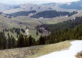
|
View from Lemhi Pass | |
| Elevation | 7,373 ft (2,247 m) |
| Traversed by | Unpaved road |
| Location |
Lemhi County, Idaho / Beaverhead County, Montana, |
| Range | Bitterroot Range of the Rocky Mountains |
| Coordinates | 44°58′27″N 113°26′42″W / 44.97417°N 113.44500°W |
|
Lemhi Pass | |
  | |
| Nearest city | Tendoy, Idaho |
|---|---|
| Coordinates | 44°58′27″N 113°26′42″W / 44.97417°N 113.44500°WCoordinates: 44°58′27″N 113°26′42″W / 44.97417°N 113.44500°W |
| NRHP Reference # | 66000313 |
| Significant dates | |
| Added to NRHP | October 15, 1966[1] |
| Designated NHL | October 9, 1960[2] |
Lemhi Pass is a high mountain pass in the Beaverhead Mountains, part of the Bitterroot Range in the Rocky Mountains and within Salmon-Challis National Forest. The pass lies on the Montana-Idaho border on the continental divide, at an elevation of 7,373 feet (2,247 m) above sea level.
History
The pass gained importance in the 18th century, when the Lemhi Shoshone acquired horses and used the route to travel between the two main parts of their homeland.[3] From the time of the Louisiana Purchase in 1803 until the Oregon Treaty in 1846 the pass marked the western border of the United States. On August 12, 1805 Meriwether Lewis and three other members of the Lewis and Clark Expedition crossed the Continental Divide at Lemhi Pass. Lewis found a "large and plain Indian road" over the pass.[4] This was the first time that white men had seen present-day Idaho:
We proceeded to the top of the dividing ridge from which I discovered immense ranges of high mountains still to the West of us with their tops partially covered in snow
The next day Lewis met Cameahwait and his band of Shoshone, and returned with them across the pass to meet Clark. On August 26, 1805 the entire expedition crossed the pass.[5]
In the early 19th century the pass was regularly used by the Blackfoot people, so that in 1824 Alexander Ross referred to the route as the Blackfoot route.[3] At that time the pass itself was known as North Pass, to distinguish from South Pass.[3] The pass derives its present name from Fort Lemhi, founded in 1855 by Mormon missionaries who were the first non-Indians to establish a sustained relationship with the Salmon River Indian people.
During the mining era the pass was used by stagecoaches, but the route fell into disuse after 1910, when the Gilmore and Pittsburgh Railroad was built through the nearby Bannock Pass.[3] Only a single track dirt road now crosses the pass.
The pass was designated a National Historic Landmark in 1960.[2]
Mineral resources
The Lemhi Pass area contains the richest deposits of thorium discovered in the United States. Rare earth elements have also been discovered in Lemhi Pass.[6] Rare earth element products include magnets, lasers, colorant for glass and enamels and X-ray machines.
See also
- Mountain passes in Montana
- List of National Historic Landmarks in Idaho
- List of National Historic Landmarks in Montana
- National Register of Historic Places listings in Lemhi County, Idaho
- National Register of Historic Places listings in Beaverhead County, Montana
References
- ↑ National Park Service (2008-04-15). "National Register Information System". National Register of Historic Places. National Park Service.
- 1 2 "Lemhi Pass". National Historic Landmark summary listing. National Park Service. Retrieved 2008-06-11.
- 1 2 3 4 Idaho State Historical Society Reference Series No. 280
- ↑ Ambrose, S.E. (1996) Undaunted Courage ISBN 0-684-82697-6 p.266
- ↑ Ambrose, pp.269-282
- ↑ Occurrence and Distribution of Rare Earths in the Lemhi Pass Thorium Veins, Idaho and Montana Mortimer H. Staatz, Van E. Shaw, and James S. Wahlberg (1972)
External links
- National Park Service - Lemhi Pass
- Reading 2: Lemhi Pass and Lolo Trail from The Lewis & Clark Expedition: Documenting the Uncharted Northwest Name, a National Park Service Teaching with Historic Places (TwHP) lesson plan.
- National Register of Historic Places Registration: Lemhi Pass
- Accompanying 10 photos, from 1958 and 1962
| Topics | |
|---|---|
| Lists by states |
|
| Lists by insular areas | |
| Lists by associated states | |
| Other areas | |
| |