Nicholasville, Kentucky
| Nicholasville, Kentucky | |
|---|---|
| City | |
|
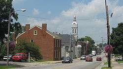
Main Street | |
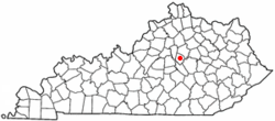 Location of Nicholasville, Kentucky | |
| Coordinates: 37°52′58″N 84°34′36″W / 37.88278°N 84.57667°WCoordinates: 37°52′58″N 84°34′36″W / 37.88278°N 84.57667°W | |
| Country | United States |
| State | Kentucky |
| County | Jessamine |
| Incorporated | February 13, 1837[1] |
| Government[2] | |
| • Type | City commission |
| • Mayor | Pete Sutherland |
| • Commissioners |
Doug Blackford Betty Black Patty Teater Andy Williams |
| Area | |
| • Total | 13.1 sq mi (33.9 km2) |
| • Land | 13.0 sq mi (33.7 km2) |
| • Water | 0.07 sq mi (0.2 km2) |
| Elevation | 938 ft (286 m) |
| Population (2012) | |
| • Total | 29,097 |
| • Density | 2,141.9/sq mi (827.0/km2) |
| Time zone | Eastern (EST) (UTC-5) |
| • Summer (DST) | EDT (UTC-4) |
| ZIP codes | 40340, 40356 |
| Area code(s) | 859 |
| FIPS code | 21-56136 |
| GNIS feature ID | 0499462 |
| Website |
www |
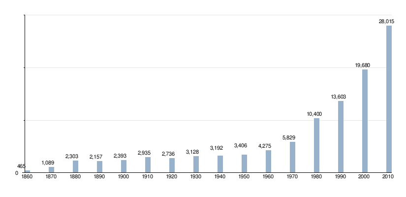
Nicholasville is a home rule-class city[3] in Jessamine County, Kentucky, in the United States. It is the seat of its county.[4] The population was 28,015 during the 2010 U.S. Census, making Nicholasville the 11th-largest settlement in the state.
Since the late 20th century, Nicholasville has undergone rapid growth; the population increased 380% between 1970 and 2010. The city serves as both a residential area for Lexington-area commuters and as an employment and shopping center for central Kentucky.[5]
The city is home to the Kentucky Wine & Vine Fest.[6] The annual festival showcases wines from commercial vineyards and amateur winemakers from across Kentucky and the surrounding region. In 2014 it was named as the "Official Wine Festival of Kentucky" by the Kentucky General Assembly.[7][8]
Geography
Nicholasville is located at 37°52′58″N 84°34′36″W / 37.882670°N 84.576585°W (37.882670, -84.576585).[9] Downtown Nicholasville is approximately 6 miles (9.7 km) south of Fayette County. The city serves as a logistics and commuter hub between Lexington and Nicholasville's neighboring counties, especially Garrard County.
According to the United States Census Bureau, the city has a total area of 13.08 square miles (33.9 km2), of which 13.01 square miles (33.7 km2) is land and 0.07 square miles (0.18 km2), or 0.52%, is water. Some artificial ponds, including Lake Mingo (named after the Native American Mingo people), are present in the city.[10] Town Fork, a partially channelized stream, runs south and passes underneath downtown, eventually draining into Jessamine Creek.[11]
Climate
Nicholasville is in the northern periphery of the humid subtropical climate zone,[12] with hot and humid summers, cool winters, and occasional mild periods, especially in autumn. The city and the surrounding Bluegrass region have four distinct seasons that include cool plateau breezes, moderate nights in the summer, and no prolonged periods of rain, snow, or other severe weather.
History
Nicholasville was founded in 1798.[13] It was not formally incorporated until 1837.[1] The town was named in honor of Colonel George Nicholas, a father of the Kentucky constitution in 1792.[14]
The Young House in Nicholasville is listed on the National Register of Historic Places.
The city has grown rapidly since the late 20th century and is working to accommodate new highways and transportation needs. Many residents commute to Lexington; others are part of building Nicholasville as a center of retail services for the county.
Government
The Nicholasville government operates under a non-partisan City Commission. The Commission is composed of an elected mayor and four commissioners. All are elected at-large, requiring each candidate to gain the support of the majority of the electorate. The commissioners are elected to manage particular city departments. They serve two-year terms; the mayor is elected to a four-year term.[2] The Commission wields all executive, legislative, and administrative powers.
In 2012 there was a proposal on the ballot to change the form of city government to that of a mayor-council, but it was defeated by 56% (5,004) to 44% (3,879) margin. Council members would have been elected from single-member districts, potentially broadening representation.[15][16]
Commissioners draft and pass laws and, by managing their respective departments, ensure the laws are carried out efficiently. The mayor administers oaths, signs documents on the city's behalf, and conducts Commission meetings. As a member of the commission, the mayor has legislative powers equal to that of the commissioners. Commission meetings take place twice monthly.[2]
Education
Nicholasville has an elementary school and is served by county middle and high schools. There are fourteen schools in Jessamine County.[17] There are two high schools, East Jessamine High School and West Jessamine High School. There are two middle schools in Jessamine County, which are East Jessamine Middle School and West Jessamine Middle School. The six elementary schools in Jessamine County include the following: Brookside Elementary School, Nicholasville Elementary School, Rosenwald-Dunbar Elementary School, Warner Elementary School, Wilmore Elementary School, and Red Oak Elementary.
Demographics
| Historical population | |||
|---|---|---|---|
| Census | Pop. | %± | |
| 1810 | 158 | — | |
| 1830 | 408 | — | |
| 1840 | 632 | 54.9% | |
| 1860 | 800 | — | |
| 1870 | 1,089 | 36.1% | |
| 1880 | 2,303 | 111.5% | |
| 1890 | 2,157 | −6.3% | |
| 1900 | 2,393 | 10.9% | |
| 1910 | 2,935 | 22.6% | |
| 1920 | 2,786 | −5.1% | |
| 1930 | 3,128 | 12.3% | |
| 1940 | 3,192 | 2.0% | |
| 1950 | 3,406 | 6.7% | |
| 1960 | 4,275 | 25.5% | |
| 1970 | 5,829 | 36.4% | |
| 1980 | 10,400 | 78.4% | |
| 1990 | 13,603 | 30.8% | |
| 2000 | 19,680 | 44.7% | |
| 2010 | 28,015 | 42.4% | |
| Est. 2015 | 29,754 | [18] | 6.2% |
As of the 2010 census,[20] there were 28,015 people, 10,492 households, and 7,503 families residing in the city. The population density was 2,141.9 per square mile (827.0/km2). There were 11,405 housing units at an average density of 872.0 per square mile (336.7/km2). The racial makeup of the city was 91.5% White (89.5% non-Hispanic), 4.3% African American, 0.2% Native American, 0.5% Asian, 0.1% Pacific Islander, 1.2% from other races, and 2.3% from two or more races. Hispanics or Latinos of any race were 3.5% of the population.
There were 10,492 households out of which 36.4% had children under the age of 18 living with them, 49.2% were married couples living together, 16.7% had a female householder with no husband present, 5.6% had a male householder with no wife present, and 26.5% were non-families. 22.3% of all households were made up of individuals and 7.4% had someone living alone who was 65 years of age or older. The average household size was 2.64 and the average family size was 3.07.
The age distribution was 27.9% under the age of 18, 8.8% from 18 to 24, 30.7% from 25 to 44, 22.8% from 45 to 64, and 9.8% who were 65 years of age or older. The median age was 33.1 years. For every 100 females there were 91.1 males. For every 100 females age 18 and over, there were 86.9 males.
According to Census Bureau data for 2011 (American Community Survey 5-year estimates), the median income for a household in the city was $43,453, and the median income for a family was $52,419. Full-time male workers had a median income of $37,954 versus $33,330 for females. The per capita income for the city was $19,526. About 14.5% of families and 17.1% of the population were below the poverty line, including 22.7% of those under age 18 and 6.5% of those age 65 or over.
Transportation
U.S. highways
- U.S. Route 27 is a major north-south artery. From the Lexington city limits to the Business US 27 intersection north of the city center; it is a four-lane arterial highway with a center-turning lane. US 27 diverts to the western edge of the city center on a four-lane, controlled-access bypass and continues south of the city toward the Kentucky River.
- Construction began on the $16 million, 6-mile (9.7 km) Nicholasville bypass in March 1986. The four-lane, controlled-access bypass opened in 1988.[21] It has seven at-grade intersections and one diamond interchange.
- Business US 27 is a variable two and four-lane arterial route running north to south of the downtown, concluding at US 27 at both ends.
State routes
- Kentucky Route 29 is an east-west two-lane highway that stretches from the western fringes of the city west of the US 27 bypass to Business US 27 in downtown Nicholasville. It is known as Wilmore Road, west of US 27 and east of Maple Street.
- Kentucky Route 39 is a north-south highway that stretches from the farms south of the city before concluding at Business US 27 at downtown. It is known as Maple Street, and as Sulphur Well Road and then Lancaster Road.
- Kentucky Route 169 is an east-west highway that cuts through the city center. It has intersections with US 27 and Business US 27. It is known as Keene Road, northwest of the city center, then 3rd Street, Richmond Road and Union Mills Road on the east side.
- Kentucky Route 1980 is known as Ash Grove Road and travels into Fayette County to the east. It departs from US 27 just south of the Lexington city limits.
- Kentucky Route 3375 traverses west of US 27, north of the city center, and is known as Catnip Hill Road.
Future roads
A new 7.4-mile (11.9 km) four-lane divided highway running from a Single-point urban interchange at US 27 north of Nicholasville to US 27 south of Nicholasville is being designed to serve the eastern half of Jessamine County's county seat.[22] The western Nicholasville bypass, signed as US 27, was completed in 1986[21] with an interchange at KY 29 and a few at-grade intersections.
The eastern bypass of Nicholasville will give commuters an option of bypassing the city, while serving the residents of the eastern half of Jessamine county. In September 2002, the Federal Highway Administration approved an environmental assessment document.[22] Right-of-way purchase, estimated at $15 million, began in 2006, with relocation of utility lines in 2007 and construction in 2008. It was to be completed in 2010 at a cost of $73 million to complete. The Kentucky Transportation Cabinet predicts that when the highway opens, 58,000 travelers will use the western bypass and 45,000 will use the eastern bypass.[22]
Transportation planning
The Lexington Area MPO is responsible for transportation planning for Fayette and Jessamine counties. This includes activities such as carpool matching, administering a commuter vanpool program, air quality forecasting, bicycle and pedestrian planning, congestion management, and developing transportation plans and documents.
Notable people
- Donald Brumfield, jockey
- Charles K. Duncan, United States Navy Admiral.
- Danny Fargo, professional wrestler.
- Lena Madesin Phillips, lawyer.
- John C. Watts, U.S. Representative.
- John Michael Montgomery, musician.
References
- 1 2 Commonwealth of Kentucky. Office of the Secretary of State. Land Office. "Nicholasville, Kentucky". Accessed 15 September 2013.
- 1 2 3 "Government: City Commission". www.nicholasville.org. Retrieved 12 October 2014.
- ↑ "Summary and Reference Guide to House Bill 331 City Classification Reform" (PDF). Kentucky League of Cities. Retrieved December 30, 2014.
- ↑ "Find a County". National Association of Counties. Retrieved 2011-06-07.
- ↑ "2009 Report to the community" (PDF) (Press release). City of Nicholasville. 2009. p. 5. Retrieved 3 October 2014.
- ↑ "Kentucky Wine and Vine homepage". www.kywineandvine.com. Retrieved 3 October 2014.
- ↑ "2014 Press Release" (PDF) (Press release). www.kywineandvine.com. 23 April 2014. Retrieved 3 October 2014.
- ↑ "Nicholasville NOW!: Kentucky Wine & Vine Fest named a Top 10 Festival". www.nicholasvillenow.org. Retrieved 3 October 2014.
- ↑ "US Gazetteer files: 2010, 2000, and 1990". United States Census Bureau. 2011-02-12. Retrieved 2011-04-23.
- ↑ "NJCPR: Parks & Pictures". Nicholasville/Jessamine County Parks & Recreation. Retrieved 13 October 2014.
- ↑ "Kentucky River Basin Assessment Report: Jessamine Creek". Kentucky Water Research Institute - University of Kentucky. August 2000. Retrieved 13 October 2014.
- ↑ How Stuff Works "Map of American climate zones" Check
|url=value (help). Retrieved 13 October 2014. - ↑ Columbia-Lipincott Gazeteer, p. 1320. (New York: Columbia University Press, 1952.
- ↑ Federal Writers' Project (1996). The WPA Guide to Kentucky. University Press of Kentucky. p. 254. Retrieved 24 November 2013.
- ↑ "Form of Government Change Campaigns, 2003-2012", International City/County Management Association; accessed 18 August 2016
- ↑ "Nicholasville City Commission: Betty Black", Jessamine Journal, 26 March 2014; accessed 18 August 2016
- ↑ "Jessamine County Schools". www.jessamine.k12.ky.us. Retrieved 2016-02-28.
- ↑ "Annual Estimates of the Resident Population for Incorporated Places: April 1, 2010 to July 1, 2015". Retrieved July 2, 2016.
- ↑ "Census of Population and Housing". Census.gov. Retrieved June 4, 2015.
- ↑ "American FactFinder". United States Census Bureau. Retrieved 2011-05-14.
- 1 2 Honeycutt, Valarie. "LEXINGTON TO GET $24 MILLION FOR ROADS STATE TO HELP CITY LAUNCH MORE THAN A DOZEN PROJECTS." Herald-Leader [Lexington] 5 Sept. 1986; accessed 10 Jan. 2007.
- 1 2 3 "Eastside Bypass Closer in Nicholasville," Herald-Leader, 7 December 2001, p. B3
External links
- Welcome to Nicholasville.org - The Official Website of Nicholasville, Kentucky
- Official website of Lexington Area Metropolitan Planning Organization
Municipalities and communities of Jessamine County, Kentucky, United States | ||
|---|---|---|
| Cities | 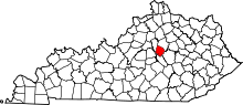 | |
| CDP | ||
| Other unincorporated communities | ||
| Ghost towns | ||
| Central city |  | |
|---|---|---|
| Municipalities with population over 10,000 | ||
| Municipalities with population 5,000-10,000 | ||
| Municipalities with population under 5,000 | ||
| Counties | ||
