Ohio County, Kentucky
| Ohio County, Kentucky | |
|---|---|
 Ohio County Courthouse in Hartford | |
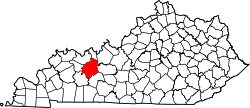 Location in the U.S. state of Kentucky | |
 Kentucky's location in the U.S. | |
| Founded | December 17, 1798 |
| Named for | The Ohio River |
| Seat | Hartford |
| Largest city | Beaver Dam |
| Area | |
| • Total | 596 sq mi (1,544 km2) |
| • Land | 587 sq mi (1,520 km2) |
| • Water | 9.0 sq mi (23 km2), 1.5% |
| Population | |
| • (2010) | 23,842 |
| • Density | 41/sq mi (16/km²) |
| Congressional district | 1st |
| Time zone | Central: UTC-6/-5 |
| Website |
ohiocounty |
Ohio County is a county located in the U.S. state of Kentucky. As of the 2010 census, the population was 23,842.[1] Its county seat is Hartford.[2] The county is named after the Ohio River, which originally formed its northern boundary. It is a dry county, which means that the sale of alcohol is restricted or prohibited.
History
Ohio County was formed in 1798 from land taken from Hardin County.[3] Ohio was the 35th Kentucky county in order of formation.[4] It was named for the Ohio River, which originally formed its northern boundary, but it lost its northern portions in 1829, when Daviess County and Hancock County were formed. The first settlements in Ohio County were Barnetts Station and Hartford. In January 1865, during the American Civil War, the courthouse in Hartford was burned by Kentucky Confederate cavalry because it was being used to house soldiers of the occupying Union Army. However, the county records were removed first and preserved. Ohio County is famous for its coal mines, which in the 1970s produced much of the nation's coal.
Geography
According to the U.S. Census Bureau, the county has a total area of 596 square miles (1,540 km2), of which 587 square miles (1,520 km2) is land and 9.0 square miles (23 km2) (1.5%) is water.[5] It is the fifth-largest county by area in Kentucky.
Ohio County is part of the Western Coal Fields region of Kentucky. Much of Ohio County is farmland and the eastern and northern parts have rolling hills. Of the 120 counties in Kentucky, it is the fifth largest. The county is intersected by the Rough River[6] and the Green River runs along its southwestern border.
Adjacent counties
- Hancock County (north)
- Breckinridge County (northeast)
- Grayson County (east)
- Butler County (southeast)
- Muhlenberg County (southwest)
- McLean County (west)
- Daviess County (northwest)
Demographics
| Historical population | |||
|---|---|---|---|
| Census | Pop. | %± | |
| 1800 | 1,223 | — | |
| 1810 | 3,792 | 210.1% | |
| 1820 | 3,879 | 2.3% | |
| 1830 | 4,715 | 21.6% | |
| 1840 | 6,592 | 39.8% | |
| 1850 | 9,749 | 47.9% | |
| 1860 | 12,209 | 25.2% | |
| 1870 | 15,561 | 27.5% | |
| 1880 | 19,669 | 26.4% | |
| 1890 | 22,946 | 16.7% | |
| 1900 | 27,287 | 18.9% | |
| 1910 | 27,642 | 1.3% | |
| 1920 | 26,473 | −4.2% | |
| 1930 | 24,469 | −7.6% | |
| 1940 | 24,421 | −0.2% | |
| 1950 | 20,840 | −14.7% | |
| 1960 | 17,725 | −14.9% | |
| 1970 | 18,790 | 6.0% | |
| 1980 | 21,765 | 15.8% | |
| 1990 | 21,105 | −3.0% | |
| 2000 | 22,916 | 8.6% | |
| 2010 | 23,842 | 4.0% | |
| Est. 2015 | 24,216 | [7] | 1.6% |
| U.S. Decennial Census[8] 1790-1960[9] 1900-1990[10] 1990-2000[11] 2010-2013[1] | |||
As of the census[12] of 2000, there were 22,916 people, 8,899 households, and 6,585 families residing in the county. The population density was 39 per square mile (15/km2). There were 9,909 housing units at an average density of 17 per square mile (6.6/km2). The racial makeup of the county was 97.71% White, 0.75% Black or African American, 0.19% Native American, 0.20% Asian, 0.03% Pacific Islander, 0.45% from other races, and 0.67% from two or more races. 1.01% of the population were Hispanic or Latino of any race.
There were 8,899 households out of which 33.00% had children under the age of 18 living with them, 61.20% were married couples living together, 9.20% had a female householder with no husband present, and 26.00% were non-families. 23.20% of all households were made up of individuals and 11.10% had someone living alone who was 65 years of age or older. The average household size was 2.54 and the average family size was 2.98.
In the county the population was spread out with 24.90% under the age of 18, 8.60% from 18 to 24, 27.50% from 25 to 44, 24.60% from 45 to 64, and 14.40% who were 65 years of age or older. The median age was 38 years. For every 100 females there were 96.60 males. For every 100 females age 18 and over, there were 94.20 males.
The median income for a household in the county was $29,557, and the median income for a family was $34,970. Males had a median income of $29,778 versus $19,233 for females. The per capita income for the county was $15,317. About 13.90% of families and 17.30% of the population were below the poverty line, including 21.90% of those under age 18 and 15.70% of those age 65 or over.
Communities
- Baizetown
- Beaver Dam
- Centertown
- Cool Springs
- Cromwell
- Dundee
- Echols
- Fordsville
- Hartford (county seat)
- Horse Branch
- Magan
- McHenry
- Pleasant Ridge
- Prentiss
- Rockport
- Rosine
Notable residents
- Tex Atchison, radio, stage and western movie musician, born near Rosine, Kentucky
- Dale Bratcher, watercolor and oil artist, native of Rockport, Kentucky
- Ramsey Carpenter, Miss Kentucky 2014, competitor for the title of Miss America 2015
- James Earp, lawman, soldier, and saloon-keeper, member of the Earp family
- Newton Earp, a Civil War soldier after moving to Iowa and the father of Wyatt Earp.
- Virgil Earp, lawman and soldier
- John Givens, first coach of Kentucky Colonels professional basketball team
- Bill Monroe, known as the father of Bluegrass music
- George H. Tichenor, inventor of Dr. Tichenor's antiseptic.
- Pendleton Vandiver, 'Uncle Pen', who inspired the music of Bill Monroe was a resident of Rosine, Kentucky
- David Wright, Artist and native of Rosine, Kentucky
See also
References
- 1 2 "State & County QuickFacts". United States Census Bureau. Retrieved March 6, 2014.
- ↑ "Find a County". National Association of Counties. Archived from the original on May 31, 2011. Retrieved 2011-06-07.
- ↑ "Ohio County". The Kentucky Encyclopedia. 2000. Retrieved August 23, 2014.
- ↑ Collins, Lewis (1882). Collins' Historical Sketches of Kentucky: History of Kentucky, Volume 2. Collins & Company. p. 26.
- ↑ "2010 Census Gazetteer Files". United States Census Bureau. August 22, 2012. Retrieved August 19, 2014.
- ↑
 Ripley, George; Dana, Charles A., eds. (1879). "Ohio. II. A W. county of Kentucky". The American Cyclopædia.
- ↑ "County Totals Dataset: Population, Population Change and Estimated Components of Population Change: April 1, 2010 to July 1, 2015". Retrieved July 2, 2016.
- ↑ "U.S. Decennial Census". United States Census Bureau. Archived from the original on May 11, 2015. Retrieved August 19, 2014.
- ↑ "Historical Census Browser". University of Virginia Library. Retrieved August 19, 2014.
- ↑ "Population of Counties by Decennial Census: 1900 to 1990". United States Census Bureau. Retrieved August 19, 2014.
- ↑ "Census 2000 PHC-T-4. Ranking Tables for Counties: 1990 and 2000" (PDF). United States Census Bureau. Retrieved August 19, 2014.
- ↑ "American FactFinder". United States Census Bureau. Archived from the original on September 11, 2013. Retrieved 2008-01-31.
External links
 Geographic data related to Ohio County, Kentucky at OpenStreetMap
Municipalities and communities of Ohio County, Kentucky, United States | ||
|---|---|---|
| Cities | | |
| CDP | ||
| Other unincorporated communities | ||

Coordinates: 37°28′N 86°50′W / 37.47°N 86.84°W