New Baltimore Historic District
|
New Baltimore Historic District | |
|
James Hampton Tavern | |
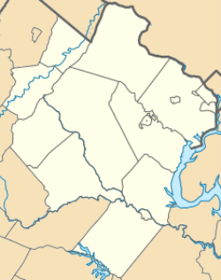   | |
| Location | Area including parts of Old Alexandria Turnpike, Mason Ln., Georgetown Rd., and Beverley's Mill Rd., New Baltimore, Virginia |
|---|---|
| Coordinates | 38°46′04″N 77°43′31″W / 38.76778°N 77.72528°WCoordinates: 38°46′04″N 77°43′31″W / 38.76778°N 77.72528°W |
| Area | 88 acres (36 ha) |
| Built | 1822 |
| Architectural style | Federal, Classical Revival, Bugalow/Craftsman |
| NRHP Reference # | 04000044[1] |
| VLR # | 030-5166 |
| Significant dates | |
| Added to NRHP | February 11, 2004 |
| Designated VLR | December 3, 2003[2] |
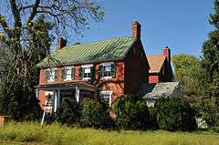
New Baltimore Historic District is a national historic district located at New Baltimore, Fauquier County, Virginia. It encompasses 55 contributing buildings and 1 contributing structure in the rural village of New Baltimore. The majority of buildings in the district are dwellings, ranging in date from the 1820s to the mid-20th centuries. Notable buildings include the Federal style James Hampton's Tavern (c. 1823), Eastview (c. 1830), and the New Baltimore School (1915). The contributing structure is a one-lane bridge (c. 1920, 1937).[3]

Fauquier Farm
It was listed on the National Register of Historic Places in 2004.[1]
References
- 1 2 National Park Service (2010-07-09). "National Register Information System". National Register of Historic Places. National Park Service.
- ↑ "Virginia Landmarks Register". Virginia Department of Historic Resources. Retrieved 5 June 2013.
- ↑ Maral S. Kalbian and Margaret T. Peters (July 2003). "National Register of Historic Places Inventory/Nomination: New Baltimore Historic District" (PDF). Virginia Department of Historic Resources. and Accompanying four photos and Accompanying map


This article is issued from Wikipedia - version of the 11/30/2016. The text is available under the Creative Commons Attribution/Share Alike but additional terms may apply for the media files.