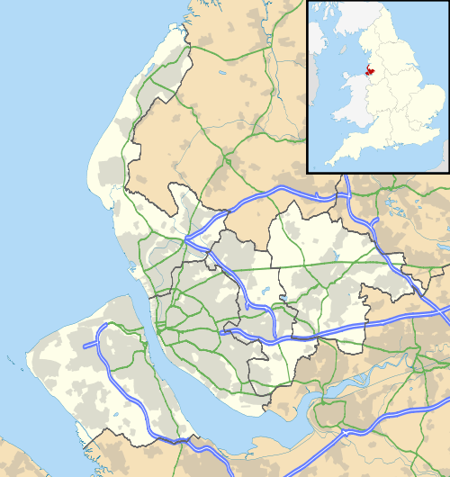
Raby, Merseyside
| Raby | |
| — Hamlet — | |
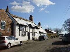 The Wheatsheaf Inn, The Green, Raby |
|
 Raby |
|
| Population | 100 (2001 Census)[1] |
|---|---|
| OS grid reference | SJ309799 |
| – London | 175 mi (282 km)[2] SE |
| Metropolitan borough | Wirral |
| Metropolitan county | Merseyside |
| Region | North West |
| Country | England |
| Sovereign state | United Kingdom |
| Post town | WIRRAL |
| Postcode district | CH63 |
| Dialling code | 0151 |
| ISO 3166 code | GB-WRL |
| Police | Merseyside |
| Fire | Merseyside |
| Ambulance | North West |
| EU Parliament | North West England |
| UK Parliament | Wirral South |
|
|
Coordinates: 53°18′43″N 3°02′17″W / 53.312°N 3.038°W
Raby (local /ˈreɪbi/) is a hamlet located within the Metropolitan Borough of Wirral, Merseyside, England. It is located at the south-central part of the Wirral Peninsula, within the Clatterbridge Ward in the parliamentary constituency of Wirral South. At the time of the United Kingdom Census 2001, Raby had a total population of 100.[1]
Raby is very near to Merseyside's boundary with Cheshire.[3] The hamlet of Raby Mere is located two miles to the east.
History
The name is of Viking origin, deriving from the Old Norse Ra-byr, meaning 'boundary settlement'.[4] It is believed to be so named because it lay close to the boundary which existed in the 10th and 11th centuries between the Norse colony in Wirral to the north, centred on Thingwall, and Anglo-Saxon Mercia to the south.[5]
Raby was a township in Neston Parish of the Wirral Hundred with a population of 131 in 1801, 195 in 1851, 350 in 1901 and 308 in 1951.[6]
Geography
Raby is in the central part of the Wirral Peninsula, approximately 12.5 km (7.8 mi) south-south-east of the Irish Sea at Leasowe Lighthouse, 3.5 km (2.2 mi) east-north-east of the Dee Estuary at Parkgate and about 5.5 km (3.4 mi) west of the River Mersey at Eastham. The hamlet is situated at an elevation of around 50 m (160 ft) above sea level.[7]
 |
Thornton Hough | Brimstage Clatterbridge |
Spital | |
| Gayton | |
Raby Mere Bromborough | ||
| ||||
| | ||||
| Neston | Hinderton Hall Leahurst Veterinary School |
Willaston |
Community
Raby is a rural community, comprising a few houses, two farms and an old, thatched public house, the 'Wheatsheaf', which is well known in the locality. The pub is owned by the Leverhulme Estate, which owns much land locally.
Raby, along with the neighbouring villages of Brimstage and Thornton Hough, are within an Area of Special Landscape Value, a protective designation to preserve the character and appearance of the area. This is part of the Wirral Unitary Development Plan of the Metropolitan Borough of Wirral.[8]
The parish church is All Saints Church, Thornton Hough. The local primary school is Thornton Hough Primary.
Transport
Road
Raby is accessible from the A540 to the south-west, the B5151 to the east and the B5136 to the north.
Bus
Services operating in the Raby Area as of 2015:
| Number | Route | Operator | Days of operation |
|---|---|---|---|
| 85 | Clatterbridge Hospital - Heswall | Avon Buses | Monday - Saturday |
Rail
The nearest station to Raby is Bromborough railway station, about 3.5 km (2.2 mi) to the east. This station is on the Wirral Line of the Merseyrail network, with frequent services to Liverpool, Chester and Ellesmere Port.
See also
References
- 1 2 "Wirral 2001 Census: Raby". Metropolitan Borough of Wirral. Retrieved 21 February 2008.
- ↑ "Coordinate Distance Calculator". boulter.com. Retrieved 6 March 2016.
- ↑ http://www.multimap.com/map/browse.cgi?client=public&GridE=-3.03800&GridN=53.31200&lon=-3.03800&lat=53.31200&search_result=Raby%2C%20Merseyside&db=freegaz&keepicon=true&lang=&place=Raby%2C%20Merseyside&pc=&advanced=&client=public&addr2=&quicksearch=raby&addr3=&scale=100000&addr1=
- ↑ Sulley, Philip (1889). The Hundred Of Wirral.
- ↑ Roberts, Stephen J. (2002). A History of Wirral. The History Press Ltd. ISBN 978-1-86077-512-3.
- ↑ "Cheshire Towns & Parishes: Raby". GENUKI UK & Ireland Genealogy. Retrieved 19 August 2007.
- ↑ "SRTM & Ordnance Survey Elevation Data in PHP". Retrieved 1 November 2016.
- ↑ "Brimstage, Raby & Thornton Hough: A Strategy for Change Management" (PDF). Thornton Hough Community Trust. p. 28. Retrieved 29 August 2007.
Bibliography
- Mortimer, William Williams (1847). The History of the Hundred of Wirral. London: Whittaker & Co. pp244-245.
External links
| Wikimedia Commons has media related to Raby, Wirral. |