Sōma, Fukushima
| Sōma 相馬市 | |||
|---|---|---|---|
| City | |||
|
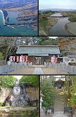
(Upper) Matsukawa Lagoon, Uda River, (Center) Soma Shrine, (Lower) Hyakusyaku Kannon, and Soma Nakamura Shrine. | |||
| |||
|
Location of Sōmain Fukushima Prefecture | |||
 Sōma
| |||
| Coordinates: 37°47′48″N 140°55′10.7″E / 37.79667°N 140.919639°ECoordinates: 37°47′48″N 140°55′10.7″E / 37.79667°N 140.919639°E | |||
| Country | Japan | ||
| Region | Tōhoku | ||
| Prefecture | Fukushima Prefecture | ||
| Government | |||
| • - Mayor | Hidekiyo Tachiya | ||
| Area | |||
| • Total | 197.67 km2 (76.32 sq mi) | ||
| Population (December 2014) | |||
| • Total | 35,680 | ||
| • Density | 179/km2 (460/sq mi) | ||
| Time zone | Japan Standard Time (UTC+9) | ||
| Symbols | |||
| • Tree | Japanese black pine | ||
| • Flowers |
Spring: sakura Summer: rugosa rose Autumn: balloon flower Winter: sazanka | ||
| • Bird | Japanese bush-warbler | ||
| Phone number | 0244-37-2117 | ||
| Address | 13 Nakamura aza Ōtesaki, Sōma-shi, Fukushima-ken 976-8601 | ||
| Website |
www | ||
Sōma (相馬市 Sōma-shi) is a city located in Fukushima Prefecture, in northern Honshū, Japan. As of December 2014, the city had an estimated population of 35,480 and a population density of 179 persons per km2. The total area was 197.67 km2.
Geography
Sōma is located in northeastern Fukushima Prefecture, bordered by the Pacific Ocean to the east and the Abukuma Plateau to the west. Sōma is closer to Sendai in Miyagi Prefecture than it is to the prefectural capital of Fukushima.
- Mountains
- Ryozan (825m)
- Rivers
- Uda River
- Coastal features
- Matsukawa Lagoon
Neighboring municipalities
- Fukushima Prefecture
- Miyagi Prefecture
History
The area of present-day Sōma was part of ancient Mutsu Province, and has been settled since at least the Jomon period. During the Edo period, much of the area was part of the holdings of Sōma Domain, home of the Sōma clan from the late Sengoku period until the Boshin War. . After the Meiji Restoration, it was organized as part of waki Province. With the establishment of the municipalities system on April 1, 1896, the area was organized into a number of towns and villages within the districts of Namekata and Uda, which had alternated between belonging to the old Iwaki Province, Mutsu Province, the second Iwaki Province, and modern Fukushima Prefecture. In 1896, Namekata and Uda were merged to create Sōma District. The town of Nakamura was established on April 1, 1889. It was raised to city status on March 31, 1954, being the city of Sōma.
2011 earthquake and tsunami
The eastern, coastal portion of Sōma was inundated by devastating tsunami flood waters following the magnitude 9.0 2011 Tōhoku earthquake and tsunami off its coastline on March 11, 2011.[1] The tsunami reached up to approximately 4 km inland in Sōma, flooded areas included Sōma Port and the Matsukawa-ura Bay area, up to the elevated Route 6 Sōma Bypass.[2] The tsunami was measured to have been 9.3 meters or higher in Sōma.[3]
Sōma is about 45 kilometres (28 miles) north of Fukushima Daiichi Nuclear Power Plant, the site of the nuclear accident that followed the tsunami.
Economy
Sōma has a mixed economy, based on agriculture, commercial fishing and light manufacturing. The area is noted for its strawberry cultivation.
Education
Sōma has two high schools, five middle schools and 10 elementary schools.
Hospital
Soma General Hospital, a public hospital with 240 beds, is located in Sōma.
Transportation
Railway
Highway
Seaports
- Port of Soma
Local attractions
- The Sōma horse-chasing Festival held on July 23 to 25 every year is a designated an Important Intangible Folk Cultural Property.[4]
- Nakamura Castle ruins
- Sōma Nakamura Shrine
- Matsukawaura Prefectural Natural Park
Noted people from Sōma
- Tochiazuma Tomoyori – sumo wrestler
- Takahiro Suzuki – professional baseball player
References
- ↑ Kyodo News, "Survivors in trauma after life-changing nightmare day", The Japan Times, 13 March 2011, p. 2.
- ↑ NHK, TV News Broadcast, 13 March 2011.
- ↑ http://www.jma.go.jp/en/tsunami/observation_2_04_20110313180559.html JMA tsunami observation data.
- ↑ Agency for Cultural Affairs (Japanese)
Further reading
Sasaki, Takashi (2013). Fukushima: vivir el desastre (in Spanish). Translated by F. Javier de Esteban Baquedano. Gijón, Spain: Satori Ediciones. ISBN 978-84-941125-3-9.
External links
| Wikimedia Commons has media related to Soma, Fukushima. |
- Sōma City official website (Japanese)
| Geology | |||||||||||||
|---|---|---|---|---|---|---|---|---|---|---|---|---|---|
| Affected areas | |||||||||||||
| Affected infrastructure | |||||||||||||
| Fukushima Daiichi nuclear disaster |
| ||||||||||||
| Aftershocks |
| ||||||||||||
| People | |||||||||||||
| Fundraisers | |||||||||||||
| Other | |||||||||||||