Courtland, Virginia
| Courtland, Virginia | |
|---|---|
| Town | |
|
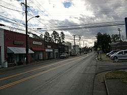
A view of Main Street in Courtland, Virginia | |
 Courtland, Virginia Location within the state of Virginia | |
| Coordinates: 36°42′57″N 77°3′58″W / 36.71583°N 77.06611°WCoordinates: 36°42′57″N 77°3′58″W / 36.71583°N 77.06611°W | |
| Country | United States |
| State | Virginia |
| County | Southampton |
| Area | |
| • Total | 0.9 sq mi (2.4 km2) |
| • Land | 0.9 sq mi (2.4 km2) |
| Elevation | 23 ft (7 m) |
| Population (2000) | |
| • Total | 1,284 |
| • Density | 1,400/sq mi (540/km2) |
| Time zone | Eastern (EST) (UTC-5) |
| • Summer (DST) | EDT (UTC-4) |
| ZIP code | 23837 |
| Area code(s) | 757 |
| FIPS code | 51-19600[1] |
| GNIS feature ID | 1498469[2] |
| Website | Official website |
Courtland is an incorporated town in Southampton County, Virginia, United States. The population was 1,284 at the 2010 census. It is the county seat of Southampton County.[3]
History
Originally named Jerusalem by English colonists, the town was given its present name in 1888. It served as Southampton County's only town through the 18th century, and has been the county seat since then. This town was formed in 1791 on the north shore of the Nottoway River, on a parcel of ten acres (40,000 m²) beside the courthouse.
In 1831, the town became notorious as the site of the trials and subsequent executions of Nat Turner and some of his cohort who had planned a major slave rebellion. According to a letter written by Solon Borland to the governor of North Carolina, the village was a small hamlet of approximately 175 people, with only three stores, one saddler, one carriage maker, two hotels, two attorneys and two physicians.
The town was the boyhood home of Confederate Major General William Mahone, whose father Fielding Mahone ran a tavern. General George H. Thomas, "Rock of Chickamauga", and a native of Southampton County, was a Union general and graduate of the United States Military Academy, likely visited his uncle James Rochelle here. Rochelle was clerk of court for Southampton County, and lived three houses from Mahone's Tavern.
Elm Grove, Mahone's Tavern, Rochelle-Prince House, Simmons-Sebrell-Camp House, and the Rebecca Vaughan House are listed on the National Register of Historic Places.[4]
Geography
Courtland is located at 36°42′57″N 77°3′58″W / 36.71583°N 77.06611°W (36.715702, -77.066063).[5]
According to the United States Census Bureau, the town has a total area of 0.9 square miles (2.4 km²), all of it land.
Demographics
| Historical population | |||
|---|---|---|---|
| Census | Pop. | %± | |
| 1900 | 288 | — | |
| 1910 | 283 | −1.7% | |
| 1920 | 379 | 33.9% | |
| 1930 | 355 | −6.3% | |
| 1940 | 459 | 29.3% | |
| 1950 | 443 | −3.5% | |
| 1960 | 855 | 93.0% | |
| 1970 | 899 | 5.1% | |
| 1980 | 976 | 8.6% | |
| 1990 | 819 | −16.1% | |
| 2000 | 1,270 | 55.1% | |
| 2010 | 1,284 | 1.1% | |
| Est. 2015 | 1,246 | [6] | −3.0% |
As of the census[1] of 2000, there were 1,270 people, 460 households, and 300 families residing in the town. The population density was 1,373.2 people per square mile (533.0/km²). There were 498 housing units at an average density of 538.5 per square mile (209.0/km²). The racial makeup of the town was 52.28% White, 47.01% African American, 0.16% Native American, 0.08% Asian, and 0.47% from two or more races. Hispanic or Latino of any race were 0.24% of the population.
There were 460 households out of which 33.9% had children under the age of 18 living with them, 42.6% were married couples living together, 20.9% had a female householder with no husband present, and 34.6% were non-families. 32.6% of all households were made up of individuals and 17.0% had someone living alone who was 65 years of age or older. The average household size was 2.35 and the average family size was 2.96.
In the town the population was spread out with 23.1% under the age of 18, 7.6% from 18 to 24, 27.0% from 25 to 44, 23.1% from 45 to 64, and 19.1% who were 65 years of age or older. The median age was 38 years. For every 100 females there were 93.9 males. For every 100 females age 18 and over, there were 87.7 males.
The median income for a household in the town was $31,750, and the median income for a family was $43,229. Males had a median income of $34,464 versus $20,714 for females. The per capita income for the town was $18,474. About 19.2% of families and 21.6% of the population were below the poverty line, including 30.6% of those under age 18 and 22.1% of those age 65 or over.
References
- 1 2 "American FactFinder". United States Census Bureau. Archived from the original on 2013-09-11. Retrieved 2008-01-31.
- ↑ "US Board on Geographic Names". United States Geological Survey. 2007-10-25. Retrieved 2008-01-31.
- ↑ "Find a County". National Association of Counties. Archived from the original on 2011-05-31. Retrieved 2011-06-07.
- ↑ National Park Service (2010-07-09). "National Register Information System". National Register of Historic Places. National Park Service.
- ↑ "US Gazetteer files: 2010, 2000, and 1990". United States Census Bureau. 2011-02-12. Retrieved 2011-04-23.
- ↑ "Annual Estimates of the Resident Population for Incorporated Places: April 1, 2010 to July 1, 2015". Retrieved July 2, 2016.
- ↑ "Census of Population and Housing". Census.gov. Archived from the original on May 11, 2015. Retrieved June 4, 2015.
External links
Municipalities and communities of Southampton County, Virginia, United States | ||
|---|---|---|
| Towns | 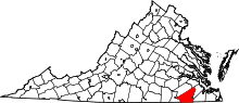 | |
| CDPs | ||
| Unincorporated communities | ||