Coeburn, Virginia
| Coeburn, Virginia | ||
|---|---|---|
| Town | ||
| ||
 Location of Coeburn, Virginia | ||
| Coordinates: 36°56′38″N 82°27′58″W / 36.94389°N 82.46611°WCoordinates: 36°56′38″N 82°27′58″W / 36.94389°N 82.46611°W | ||
| Country | United States | |
| State | Virginia | |
| County | Wise | |
| Area | ||
| • Total | 2.0 sq mi (5.3 km2) | |
| • Land | 2.0 sq mi (5.3 km2) | |
| • Water | 0.0 sq mi (0.0 km2) | |
| Elevation | 1,995 ft (608 m) | |
| Population (2010) | ||
| • Total | 2,139 | |
| • Density | 973.8/sq mi (376.0/km2) | |
| Time zone | Eastern (EST) (UTC-5) | |
| • Summer (DST) | EDT (UTC-4) | |
| ZIP code | 24230 | |
| Area code(s) | 276 | |
| FIPS code | 51-17952[1] | |
| GNIS feature ID | 1482614[2] | |
| Website | Official website | |
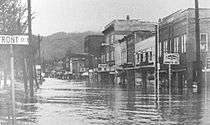
Coeburn is a town in Wise County, Virginia, along the Guest River. The population was 2139 at the 2010 census with many small peaceful wooded communities in the outskirts. Camping is available nearby at Bark Camp Lake in the Jefferson National Forest with other activities including boating and fishing. The Guest River Gorge Trail, built along the Guest River on what was formerly the Interstate Railroad is also located in the Jefferson National Forest and is a popular place to walk or ride a bicycle. Recently Coeburn joined with neighboring town Saint Paul on the Mountain View Trail System for ATVs
History
The Tacoma School was listed on the National Register of Historic Places in 1997.[3]
Geography
Coeburn is located at 36°56′38″N 82°27′58″W / 36.943872°N 82.466069°W (36.943872, -82.466069).[4]
According to the United States Census Bureau, the town has a total area of 2.0 square miles (5.3 km2), all of it land. Coeburn has many mountains and hills.
Demographics
| Historical population | |||
|---|---|---|---|
| Census | Pop. | %± | |
| 1900 | 295 | — | |
| 1910 | 645 | 118.6% | |
| 1920 | 884 | 37.1% | |
| 1930 | 784 | −11.3% | |
| 1940 | 764 | −2.6% | |
| 1950 | 760 | −0.5% | |
| 1960 | 2,471 | 225.1% | |
| 1970 | 2,362 | −4.4% | |
| 1980 | 2,625 | 11.1% | |
| 1990 | 2,165 | −17.5% | |
| 2000 | 1,996 | −7.8% | |
| 2010 | 2,139 | 7.2% | |
| Est. 2015 | 1,999 | [5] | −6.5% |
As of the census[1] of 2000, there were 1,996 people, 810 households, and 575 families residing in the town. The population density was 973.8 people per square mile (375.9/km2). There were 923 housing units at an average density of 450.3 per square mile (173.8/km2). The racial makeup of the town was 95.29% White, 2.81% African American, 0.20% Native American, 0.10% Asian, 0.05% Pacific Islander, 0.05% from other races, and 1.50% from two or more races. Hispanic or Latino of any race were 0.60% of the population.
There were 810 households out of which 29.6% had children under the age of 18 living with them, 50.2% were married couples living together, 16.3% had a female householder with no husband present, and 28.9% were non-families. 26.0% of all households were made up of individuals and 11.6% had someone living alone who was 65 years of age or older. The average household size was 2.44 and the average family size was 2.92.
In the town the population was spread out with 22.5% under the age of 18, 9.4% from 18 to 24, 28.6% from 25 to 44, 23.9% from 45 to 64, and 15.6% who were 65 years of age or older. The median age was 39 years. For every 100 females there were 93.4 males. For every 100 females age 18 and over, there were 90.5 males.
The median income for a household in the town was $25,025, and the median income for a family was $28,929. The per capita income for the town was $12,802. About 17.0% of families and 20.5% of the population were below the poverty line, including 29.9% of those under age 18 and 7.8% of those age 65 or over.
Education
Coeburn is home to three public schools: Coeburn Primary, Coeburn Middle, and Eastside High.
Government
The Town of Coeburn is governed under a Manager/Council form of government with 5 elected Council members elected at large in May.
Notable people
- Holly Kiser - First Make Me a Supermodel Winner
- Jesse McReynolds - Bluegrass Musician
- Danny O'Quinn Jr. - Professional Stock Car Racer
- Tracy Stallard - Professional Baseball Player
- Ralph Stanley - Bluegrass Musician
References
- 1 2 "American FactFinder". United States Census Bureau. Archived from the original on 2013-09-11. Retrieved 2008-01-31.
- ↑ "US Board on Geographic Names". United States Geological Survey. 2007-10-25. Retrieved 2008-01-31.
- ↑ National Park Service (2010-07-09). "National Register Information System". National Register of Historic Places. National Park Service.
- ↑ "US Gazetteer files: 2010, 2000, and 1990". United States Census Bureau. 2011-02-12. Retrieved 2011-04-23.
- ↑ "Annual Estimates of the Resident Population for Incorporated Places: April 1, 2010 to July 1, 2015". Retrieved July 2, 2016.
- ↑ "Census of Population and Housing". Census.gov. Archived from the original on May 11, 2015. Retrieved June 4, 2015.
External links
Municipalities and communities of Wise County, Virginia, United States | ||
|---|---|---|
| Towns | 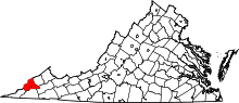 | |
| CDP | ||
| Unincorporated communities | ||
| Footnotes | ‡This populated place also has portions in an adjacent county or counties | |