Perambalur district
| Perambalur district பெரம்பலூர் மாவட்டம் | |
|---|---|
| district | |
|
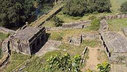
Perambalur Ranchankudi Fort | |
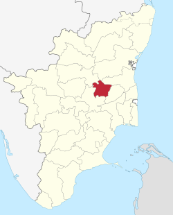 Location in Tamil Nadu, India | |
| Coordinates: 11°14′.6″N 78°52′59.92″E / 11.233500°N 78.8833111°ECoordinates: 11°14′.6″N 78°52′59.92″E / 11.233500°N 78.8833111°E | |
| Country |
|
| State | Tamil Nadu |
| Headquarters | Perambalur |
| Government | |
| • Collector | K Nandhakumar IAS |
| • Superintendent of Police | Sonal Chandra IPS |
| Area | |
| • Total | 1,752 km2 (676 sq mi) |
| Population (2011)[1] | |
| • Total | 565,223 |
| • Density | 320/km2 (840/sq mi) |
| Languages | |
| • Official | Tamil |
| Time zone | IST (UTC+5:30) |
| PIN | 621220 |
| Telephone code | 04328 |
| Vehicle registration | TN-46[2] |
| Sex ratio | 0.993 ♂/♀ |
| Literacy | 65.88%% |
| Climate | Semi-arid (Köppen) |
| Precipitation | 908 millimetres (35.7 in) |
| Website |
perambalur |
Perambalur (Tamil: பெரம்பலூர் மாவட்டம்) is an administrative district in the state of Tamil Nadu, India. The district headquarters is located at Perambalur. The district occupies an area of 1,752 km² and had a population of 565,223 with a sex-ratio of 1,003 females for every 1,000 males in 2011.
Perambalur district is a centrally located inland district of Tamil Nadu. It was trifurcated from the erstwhile composite Tiruchirappalli district and was formed on 1 November 1995. The district is bounded by Cuddalore district in the north, Tiruchirappalli district in the south, Ariyalur in the east and Namakkal and Tiruchirappalli districts in the west.
Geography
The district lies in the Southern plateau & hill zone of Agro-climate regional planning with characteristics of semi-arid climate.And also the world class Black Granite in Pachai malai Hills. The soil is predominantly red loamy and black soil. The normal rainfall of the district is 908 mm which is less than 946.9 mm, the normal rainfall of the State. The precipitation during northeast monsoon, southwest monsoon and remaining winter & hot weather period account for 52%, 34% and 14% of annual rainfall, respectively.
Cauvery is the major river flowing in the region and the composite district has a canal system covering just 47 km stretch and ayacut of 11,610 ha. The ground water resource through tubewells and wells contribute nearly 68% of irrigated area command. The major crops grown in the district are paddy, groundnut, sugarcane and millets. Cashew is the major plantation crop. Now the major cultivation is small Onion, totally 24% in Tamil Nadu i.e. first place in Tamil Nadu. The Onion cultivation villages are Nakkasalem, Ammapalayam, Siruvayalur, Chettikulam, Kalarampatty, Esanai, Melapuliyur, Navalur, K.Pudur, Arumbavur,Irur,Alathur,Padalur and etc.
Economy
Currently, Perambalur district is the top maize and Onion (small) producer in Tamil Nadu, with 27% and 50% of the state's share respectively.[3]
Perambalur is planning to set up multi-product SEZ over an area of 5000 acres (20 km²) specializing in high-technology by SREI Infrastructure Finance Ltd through a Joint Venture with TIDCO (Tamil Nadu Industrial Development Corporation). The SEZ will have linkages to Cuddalore, Pondicherry and Chennai ports, railway line and Tiruchirapalli Airport. This SEZ will bring in high-technology industries, MROs, biotechnology, pharmaceutical companies, textile & leather clusters. The project is being developed with world-class infrastructure to be able to compete with the best investment centres in the world. Perambalur SEZ has a large hinterland that offers huge labour force. The SEZ is well connected with all major cities/regions of the country with excellent road/rail network. The SEZ will focus on testing & certification facilities, warehouses, and infrastructure on demand etc. In addition, residential & recreational complexes are planned within the SEZ.
Banking
Most of the leading Nationalised and private Banks including Bank of India,Axis Bank, HDFC, Laxmi vilas bank,Karur vysya bank, Corporation bank, South Indian bank, Repco bank, Tamil Nadu merchantile bank, HDFC, Union bank, ICICI, SBI, Bank of Baroda, canara bank, IOB, Indian Bank has opened their branches at perambalur.
Industries
Perambalur Sugar Mills
Perambalur Sugar Mills is sugar mill of Perambalur Sugar Mills Limited, a Subsidiary of Tamil Nadu Sugar Corporation Limited (TASCO) located at Eraiyur, Permbalur. It commenced its operation on 1976 and has a capacity of 2500 TCD.
MRF Limited
MRF Limited commissioned its 8th plant at Naranamangalam, Perambalur on 2011 for the production of conventional tyres. It commissioned its 9th plant at the same facility on 2012 solely for the manufacture of Radial Tyres.
Divisions
The district for administrative purpose has been divided into three taluks (Perambalur, Kunnam, Veppanthattai) which is further sub-divided into four blocks viz. Perambalur, Veppanthattai, Veppur, Alathur. The district comprises 121 village panchayats, four town panchayats and one municipality. The District Collector of Perambalur is K.Nandha Kumar IAS
Demographics
According to 2011 census, Perambalur district had a population of 565,223 with a sex-ratio of 1,003 females for every 1,000 males, much above the national average of 929.[4] A total of 59,567 were under the age of six, constituting 31,135 males and 28,432 females. Scheduled Castes and Scheduled Tribes accounted for 31.01% and .46% of the population respectively. The average literacy of the district was 66.49%, compared to the national average of 72.99%.[4] The district had a total of 149,243 households. There were a total of 299,726 workers, comprising 107,542 cultivators, 91,135 main agricultural labourers, 4,365 in house hold industries, 52,055 other workers, 44,629 marginal workers, 9,762 marginal cultivators, 27,143 marginal agricultural labourers, 978 marginal workers in household industries and 6,746 other marginal workers.[5]
References
- ↑ "2011 Census of India" (Excel). Indian government. 16 April 2011.
- ↑ www.tn.gov.in
- ↑ Tamil Nadu: Agriculture Department
- 1 2 "Census Info 2011 Final population totals". Office of The Registrar General and Census Commissioner, Ministry of Home Affairs, Government of India. 2013. Retrieved 26 January 2014.
- ↑ "Census Info 2011 Final population totals - Perambalur district". Office of The Registrar General and Census Commissioner, Ministry of Home Affairs, Government of India. 2013. Retrieved 26 January 2014.
namaiyur(vill)
External links
| Wikimedia Commons has media related to Perambalur district. |
| State symbols |
|
|---|---|
| Governance |
|
| Topics | |
| Districts |
|
| Major cities | |
| District Headquarters |  | |
|---|---|---|
| Country | ||
| State | ||
| Region | ||
| Taluks | ||
| Blocks | ||
| Municipalities | ||
| History | ||
| Places of interest | ||
| ||