Arcadia, Indiana
| Arcadia, Indiana | |
|---|---|
| Town | |
| Arcadia | |
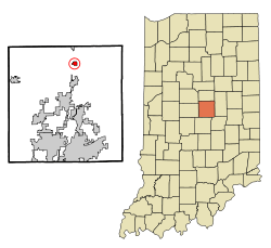 Location in the state of Indiana | |
| Coordinates: 40°10′32″N 86°1′11″W / 40.17556°N 86.01972°WCoordinates: 40°10′32″N 86°1′11″W / 40.17556°N 86.01972°W | |
| Country | United States |
| State | Indiana |
| County | Hamilton |
| Township | Jackson |
| Area[1] | |
| • Total | 0.56 sq mi (1.45 km2) |
| • Land | 0.56 sq mi (1.45 km2) |
| • Water | 0 sq mi (0 km2) |
| Elevation[2] | 860 ft (262 m) |
| Population (2010)[3] | |
| • Total | 1,666 |
| • Estimate (2012)[4] | 1,689 |
| • Density | 2,975.0/sq mi (1,148.7/km2) |
| Time zone | EST (UTC−5) |
| • Summer (DST) | EST (UTC−5) |
| ZIP code | 46030 |
| Area code | 317 |
| FIPS code[2][5] | 18-01954 |
| GNIS ID[2][5] | 430234 |
Arcadia is a town in Jackson Township, Hamilton County, Indiana, United States. The population was 1,666 at the 2010 census.
History
Arcadia was laid out in 1849 in anticipation of a new railroad being extended to that point.[6][7] It was named after the ancient region of Arcadia, in Greece.[8] The Arcadia post office opened in 1852.[9]
Geography
Arcadia is located at 40°10′32″N 86°1′11″W / 40.17556°N 86.01972°W (40.175429, -86.019776).[10]
According to the 2010 census, Arcadia has a total area of 0.56 square miles (1.45 km2), all land.[1]
Demographics
| Historical population | |||
|---|---|---|---|
| Census | Pop. | %± | |
| 1880 | 433 | — | |
| 1890 | 670 | 54.7% | |
| 1900 | 1,413 | 110.9% | |
| 1910 | 990 | −29.9% | |
| 1920 | 1,060 | 7.1% | |
| 1930 | 912 | −14.0% | |
| 1940 | 968 | 6.1% | |
| 1950 | 1,073 | 10.8% | |
| 1960 | 1,271 | 18.5% | |
| 1970 | 1,338 | 5.3% | |
| 1980 | 1,801 | 34.6% | |
| 1990 | 1,468 | −18.5% | |
| 2000 | 1,747 | 19.0% | |
| 2010 | 1,666 | −4.6% | |
| Est. 2015 | 1,666 | [11] | 0.0% |
2010 census
As of the 2010 census,[3] there were 1,666 people, 612 households, and 427 families residing in the town. The population density was 2,975.0 inhabitants per square mile (1,148.7/km2). There were 683 housing units at an average density of 1,219.6 per square mile (470.9/km2). The racial makeup of the town was 97.7% White, 0.4% African American, 0.2% Native American, 0.2% Asian, 0.2% from other races, and 1.2% from two or more races. Hispanic or Latino of any race were 0.8% of the population.
There were 612 households of which 39.7% had children under the age of 18 living with them, 49.3% were married couples living together, 12.7% had a female householder with no husband present, 7.7% had a male householder with no wife present, and 30.2% were non-families. 24.7% of all households were made up of individuals and 11.3% had someone living alone who was 65 years of age or older. The average household size was 2.62 and the average family size was 3.07.
The median age in the town was 36 years. 27.9% of residents were under the age of 18; 8.7% were between the ages of 18 and 24; 27.3% were from 25 to 44; 23.3% were from 45 to 64; and 12.5% were 65 years of age or older. The gender makeup of the town was 49.9% male and 50.1% female.
2000 census
As of the 2000 census,[13] there were 1,747 people, 582 households, and 427 families residing in the town. The population density was 3,176.1 people per square mile (1,226.4/km²). There were 607 housing units at an average density of 1,103.5 per square mile (426.1/km²). The racial makeup of the town was 96.22% White, 0.92% African American, 0.57% Native American, 0.23% Asian, 0.52% from other races, and 1.55% from two or more races. Hispanic or Latino of any race were 1.09% of the population.
There were 582 households out of which 38.3% had children under the age of 18 living with them, 57.9% were married couples living together, 9.3% had a female householder with no husband present, and 26.6% were non-families. 22.0% of all households were made up of individuals and 7.9% had someone living alone who was 65 years of age or older. The average household size was 2.67 and the average family size was 3.11.
In the town the population was spread out with 26.8% under the age of 18, 7.3% from 18 to 24, 34.9% from 25 to 44, 20.8% from 45 to 64, and 10.3% who were 65 years of age or older. The median age was 35 years. For every 100 females there were 101.7 males. For every 100 females age 18 and over, there were 96.5 males.
The median income for a household in the town was $44,063, and the median income for a family was $48,833. Males had a median income of $35,435 versus $25,313 for females. The per capita income for the town was $17,159. About 6.0% of families and 10.5% of the population were below the poverty line, including 7.6% of those under age 18 and 12.5% of those age 65 or over.
Education
School districts
The high school competes in the Mid-Indiana Conference (MIC) for athletics.
References
- 1 2 "G001 - Geographic Identifiers - 2010 Census Summary File 1". United States Census Bureau. Retrieved 2015-07-13.
- 1 2 3 "Feature ID 430234". Geographic Names Information System. United States Geological Survey. Retrieved June 30, 2014.
- 1 2 "American FactFinder". United States Census Bureau. Retrieved 2012-12-11.
- ↑ "Population Estimates". United States Census Bureau. Archived from the original on 2013-06-17. Retrieved 2013-06-25.
- 1 2 "FIPS55 Data: Indiana". FIPS55 Data. United States Geological Survey. February 23, 2006. Archived from the original on June 18, 2006. Retrieved June 30, 2014. External link in
|work=(help) - ↑ Haines, John F. (1915). History of Hamilton County, Indiana: Her People, Industries And Institutions, Volume 1. B.F. Bowen & Co. p. 224.
- ↑ "Hamilton County History Timeline". Carmel Clay Historical Society. Retrieved 31 May 2014.
- ↑ Baker, Ronald L. (October 1995). From Needmore to Prosperity: Hoosier Place Names in Folklore and History. Indiana University Press. p. 53. ISBN 978-0-253-32866-3.
...the ancient Greek district...
- ↑ "Hamilton County". Jim Forte Postal History. Retrieved 16 September 2014.
- ↑ "US Gazetteer files: 2010, 2000, and 1990". United States Census Bureau. 2011-02-12. Retrieved 2011-04-23.
- ↑ "Annual Estimates of the Resident Population for Incorporated Places: April 1, 2010 to July 1, 2015". Retrieved July 2, 2016.
- ↑ "Census of Population and Housing". Census.gov. Archived from the original on May 11, 2015. Retrieved June 4, 2015.
- ↑ "American FactFinder". United States Census Bureau. Archived from the original on 2013-09-11. Retrieved 2008-01-31.
Municipalities and communities of Hamilton County, Indiana, United States | ||
|---|---|---|
| Cities | ||
| Towns | ||
| Townships | ||
| Unincorporated communities |
| |
| Footnotes | ‡This populated place also has portions in an adjacent county or counties | |