Fortville, Indiana
| Town of Fortville, Indiana | |
|---|---|
| Town | |
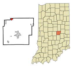 Location in the state of Indiana | |
| Coordinates: 39°56′5″N 85°50′50″W / 39.93472°N 85.84722°WCoordinates: 39°56′5″N 85°50′50″W / 39.93472°N 85.84722°W | |
| Country | United States |
| State | Indiana |
| County | Hancock |
| Township | Vernon |
| Area[1] | |
| • Total | 2.99 sq mi (7.74 km2) |
| • Land | 2.98 sq mi (7.72 km2) |
| • Water | 0.01 sq mi (0.03 km2) |
| Elevation | 856 ft (261 m) |
| Population (2010)[2] | |
| • Total | 3,929 |
| • Estimate (2012[3]) | 3,956 |
| • Density | 1,318.5/sq mi (509.1/km2) |
| Time zone | EST (UTC-5) |
| • Summer (DST) | EDT (UTC-4) |
| ZIP code | 46040 |
| Area code(s) | 317 |
| FIPS code | 18-24286[4] |
| GNIS feature ID | 0434692[5] |
| Website |
fortvilleindiana |
Fortville is a town in Vernon Township, Hancock County, Indiana, United States. The population was 3,929 at the 2010 census.
History
Fortville was originally called Walpole, and under the latter name was laid out and platted in 1849.[6] It was named for Cephas Fort, the original owner of the town site.[7] Fortville was incorporated as a town in 1865.[8]
Browne-Rafert House was listed on the National Register of Historic Places in 2015.[9]
Geography
Fortville is located at 39°56′5″N 85°50′50″W / 39.93472°N 85.84722°W (39.934740, -85.847237).[10]
According to the 2010 census, Fortville has a total area of 2.99 square miles (7.74 km2), of which 2.98 square miles (7.72 km2) (or 99.67%) is land and 0.01 square miles (0.03 km2) (or 0.33%) is water.[1]
Despite occasional droughts throughout central Indiana, Fortville has a steady and reliable supply of water because it is situated over a natural aquifer.
Demographics
| Historical population | |||
|---|---|---|---|
| Census | Pop. | %± | |
| 1870 | 387 | — | |
| 1880 | 634 | 63.8% | |
| 1890 | 685 | 8.0% | |
| 1900 | 1,006 | 46.9% | |
| 1910 | 1,174 | 16.7% | |
| 1920 | 1,213 | 3.3% | |
| 1930 | 1,289 | 6.3% | |
| 1940 | 1,463 | 13.5% | |
| 1950 | 1,786 | 22.1% | |
| 1960 | 2,209 | 23.7% | |
| 1970 | 2,460 | 11.4% | |
| 1980 | 2,787 | 13.3% | |
| 1990 | 2,690 | −3.5% | |
| 2000 | 3,444 | 28.0% | |
| 2010 | 3,929 | 14.1% | |
| Est. 2015 | 3,957 | [11] | 0.7% |
2010 census
As of the census[2] of 2010, there were 3,929 people, 1,553 households, and 1,060 families residing in the town. The population density was 1,318.5 inhabitants per square mile (509.1/km2). There were 1,705 housing units at an average density of 572.1 per square mile (220.9/km2). The racial makeup of the town was 96.2% White, 1.3% African American, 0.3% Native American, 0.1% Asian, 0.9% from other races, and 1.3% from two or more races. Hispanic or Latino of any race were 2.3% of the population.
There were 1,553 households of which 37.7% had children under the age of 18 living with them, 47.6% were married couples living together, 14.5% had a female householder with no husband present, 6.1% had a male householder with no wife present, and 31.7% were non-families. 26.8% of all households were made up of individuals and 9.1% had someone living alone who was 65 years of age or older. The average household size was 2.53 and the average family size was 3.03.
The median age in the town was 35.7 years. 28.3% of residents were under the age of 18; 7.4% were between the ages of 18 and 24; 28.4% were from 25 to 44; 24.1% were from 45 to 64; and 11.6% were 65 years of age or older. The gender makeup of the town was 48.6% male and 51.4% female.
2000 census
As of the census[4] of 2000, there were 3,444 people, 1,394 households, and 950 families residing in the town. The population density was 2,831.8 people per square mile (1,089.9/km²). There were 1,454 housing units at an average density of 1,195.5 per square mile (460.2/km²). The racial makeup of the town was 98.14% White, 0.06% African American, 0.06% Native American, 0.17% Asian, 0.73% from other races, and 0.84% from two or more races. Hispanic or Latino of any race were 1.74% of the population.
There were 1,394 households out of which 36.2% had children under the age of 18 living with them, 52.4% were married couples living together, 11.9% had a female householder with no husband present, and 31.8% were non-families. 27.8% of all households were made up of individuals and 11.8% had someone living alone who was 65 years of age or older. The average household size was 2.46 and the average family size was 3.03.
In the town the population was spread out with 27.8% under the age of 18, 7.9% from 18 to 24, 33.0% from 25 to 44, 19.4% from 45 to 64, and 11.9% who were 65 years of age or older. The median age was 34 years. For every 100 females there were 91.2 males. For every 100 females age 18 and over, there were 85.2 males.
The median income for a household in the town was $42,642, and the median income for a family was $49,010. Males had a median income of $37,723 versus $25,951 for females. The per capita income for the town was $17,745. About 4.3% of families and 6.5% of the population were below the poverty line, including 9.8% of those under age 18 and 8.4% of those age 65 or over.
Features
The Town of Fortville, founded in 1849, has been named a Tree City USA community for six consecutive years. The original town was called Phoebe's Corner (Walpole Post Office) and located two miles northwest of the current town. It was literally moved when the Bee Line Railroad was built. A large statue of a pink elephant drinking a martini and wearing eyeglasses is located outside of a local liquor store in Fortville. Residents say this is one of the most recognizable landmarks in the town. Besides SR 67 that passes through the town, historic Main Street can be found north of its stoplight. This 1890s business district is lined with brick historic buildings, trees, streetlights with flower baskets and local shops. Festivals at Christmas and Bastille Day occur on the Main Street and the nearby parks.
Classic Car Shows - every Wednesday night in the summer Main Street comes alive with vintage beauties from 5pm to dark (unless it is raining). Every year since 2012 it has grown and not only have the cars lined Main Street, they have spilled into the side streets and parking lots. It's not only the cars that attract people but also the town itself. Multiple restaurants and unique artisan shops round out your visit. For example, the Indulge ice cream shop fits in so nicely with these car enthusiasts with its vintage vibe.
Location
Fortville is located 6 miles (11 minutes) Southeast from Hamilton Town Center / I69. It is 12 miles (21 minutes) from I465 and East 42nd Street on the East side of Indianapolis.
Parks
Landmark Park is located at Staat Street and Veteran's Court, just east of Main Street.
The entrance to Memorial Park is located just west of Church and McCarty streets.
Economic development
The Fortville Redevelopment Commission was established in December 2002. The commission is responsible for the development of the industrial base within the Town of Fortville.
On April 8, 2003, the Town Council approved the resolution establishing approximately 26 acres (11 ha) of I-1 industrial property into a TIF district. The TIF district allows for the Municipality to install utility infrastructure to entice prospective partners to locate in Fortville. All of the lots in the Business Park have been sold. The two newest businesses are The Plaquemaker and Holloway House.
Economic Development is seen as an important factor in the success of the community.
The towns of Fortville and McCordsville have combined to form a Chamber of Commerce.
Fortville Action Inc. is a citizens group that has been instrumental in a grass roots redevelopment effort including the towns recognition as an Indiana Main Street Community.
Currently a comprehensive masterplan and Main Street redevelopment plan for the area is underway. The Master plan is entitled Envision Fortville with a steering committee composed of local residents, businesses, organizations and town council members.
References
- 1 2 "G001 - Geographic Identifiers - 2010 Census Summary File 1". United States Census Bureau. Retrieved 2015-07-16.
- 1 2 "American FactFinder". United States Census Bureau. Retrieved 2012-12-11.
- ↑ "Population Estimates". United States Census Bureau. Retrieved 2013-06-25.
- 1 2 "American FactFinder". United States Census Bureau. Retrieved 2008-01-31.
- ↑ "US Board on Geographic Names". United States Geological Survey. 2007-10-25. Retrieved 2008-01-31.
- ↑ Binford, John H. (1882). History of Hancock County, Indiana: From Its Earliest Settlement by the "pale Face," in 1818, Down to 1882. King & Binford. p. 326.
- ↑ Richman, George J. (1916). History of Hancock County, Indiana: Its People, Industries and Institutions. Wm. Mitchell Printing Company. p. 798.
- ↑ Baker, Ronald L. (October 1995). From Needmore to Prosperity: Hoosier Place Names in Folklore and History. Indiana University Press. p. 135. ISBN 978-0-253-32866-3.
When the town was incorporated in 1865...
- ↑ "National Register of Historic Places Listings". Weekly List of Actions Taken on Properties: 9/14/15 through 9/18/15. National Park Service. 2015-09-25.
- ↑ "US Gazetteer files: 2010, 2000, and 1990". United States Census Bureau. 2011-02-12. Retrieved 2011-04-23.
- ↑ "Annual Estimates of the Resident Population for Incorporated Places: April 1, 2010 to July 1, 2015". Retrieved July 2, 2016.
- ↑ "Census of Population and Housing". Census.gov. Retrieved June 4, 2015.
External links
Municipalities and communities of Hancock County, Indiana, United States | ||
|---|---|---|
| City | ||
| Towns | ||
| Townships | ||
| Unincorporated communities |
| |
| Footnotes | ‡This populated place also has portions in an adjacent county or counties | |