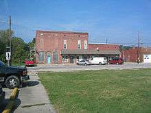
Brooklyn, Indiana
| Brooklyn, Indiana | |
|---|---|
| Town | |
|
The town seen from the east | |
 Location in the state of Indiana | |
| Coordinates: 39°32′29″N 86°22′12″W / 39.54139°N 86.37000°WCoordinates: 39°32′29″N 86°22′12″W / 39.54139°N 86.37000°W | |
| Country | United States |
| State | Indiana |
| County | Morgan |
| Township | Clay |
| Area[1] | |
| • Total | 0.68 sq mi (1.76 km2) |
| • Land | 0.67 sq mi (1.74 km2) |
| • Water | 0.01 sq mi (0.03 km2) |
| Elevation[2] | 663 ft (202 m) |
| Population (2010)[3] | |
| • Total | 1,598 |
| • Estimate (2012)[4] | 1,603 |
| • Density | 2,385.1/sq mi (920.9/km2) |
| Time zone | EST (UTC-5) |
| • Summer (DST) | EST (UTC-5) |
| ZIP code | 46158 |
| Area code | 317 |
| FIPS code[2][5] | 18-08038 |
| GNIS ID[2][5] | 431572 |

Brooklyn is a town in Clay Township, Morgan County, Indiana, United States. The population was 1,598 at the 2010 census.
History
Brooklyn was laid out in 1854, at about the time the railroad was extended to that point.[6] The town probably took its name after Brooklyn, New York.[7] A post office has been in operation at Brooklyn since 1856.[8]
The Franklin Landers-Black and Adams Farm was listed on the National Register of Historic Places in 2000.[9]
Geography
Brooklyn is located at 39°32′29″N 86°22′12″W / 39.54139°N 86.37000°W (39.541391, -86.370021).[10]
According to the 2010 census, Brooklyn has a total area of 0.68 square miles (1.76 km2), of which 0.67 square miles (1.74 km2) (or 98.53%) is land and 0.01 square miles (0.03 km2) (or 1.47%) is water.[1]
Demographics
| Historical population | |||
|---|---|---|---|
| Census | Pop. | %± | |
| 1880 | 244 | — | |
| 1910 | 572 | — | |
| 1920 | 528 | −7.7% | |
| 1930 | 545 | 3.2% | |
| 1940 | 485 | −11.0% | |
| 1950 | 592 | 22.1% | |
| 1960 | 866 | 46.3% | |
| 1970 | 911 | 5.2% | |
| 1980 | 888 | −2.5% | |
| 1990 | 1,162 | 30.9% | |
| 2000 | 1,545 | 33.0% | |
| 2010 | 1,598 | 3.4% | |
| Est. 2015 | 1,601 | [11] | 0.2% |
2010 census
As of the 2010 census,[3] there were 1,598 people, 580 households, and 455 families residing in the town. The population density was 2,385.1 inhabitants per square mile (920.9/km2). There were 630 housing units at an average density of 940.3 per square mile (363.1/km2). The racial makeup of the town was 97.8% White, 0.2% African American, 0.4% Native American, 0.2% Asian, 0.7% from other races, and 0.8% from two or more races. Hispanic or Latino of any race were 1.8% of the population.
There were 580 households of which 40.3% had children under the age of 18 living with them, 58.4% were married couples living together, 15.2% had a female householder with no husband present, 4.8% had a male householder with no wife present, and 21.6% were non-families. 16.9% of all households were made up of individuals and 5.5% had someone living alone who was 65 years of age or older. The average household size was 2.76 and the average family size was 3.05.
The median age in the town was 34.7 years. 28.1% of residents were under the age of 18; 8.5% were between the ages of 18 and 24; 26.5% were from 25 to 44; 25.8% were from 45 to 64; and 11% were 65 years of age or older. The gender makeup of the town was 50.4% male and 49.6% female.
2000 census
As of the 2000 census,[13] there were 1,545 people, 553 households, and 435 families residing in the town. The population density was 1,988.5 people per square mile (764.8/km²). There were 577 housing units at an average density of 742.6 per square mile (285.6/km²). The racial makeup of the town was 96.70% White, 0.39% Native American, 0.06% Asian, 0.06% from other races, and 2.78% from two or more races. Hispanic or Latino of any race were 1.04% of the population.
There were 553 households out of which 40.7% had children under the age of 18 living with them, 62.9% were married couples living together, 11.0% had a female householder with no husband present, and 21.3% were non-families. 17.5% of all households were made up of individuals and 6.5% had someone living alone who was 65 years of age or older. The average household size was 2.79 and the average family size was 3.11.
In the town the population was spread out with 30.3% under the age of 18, 8.2% from 18 to 24, 35.8% from 25 to 44, 18.7% from 45 to 64, and 7.1% who were 65 years of age or older. The median age was 32 years. For every 100 females there were 107.4 males. For every 100 females age 18 and over, there were 103.6 males.
The median income for a household in the town was $42,880, and the median income for a family was $44,563. Males had a median income of $35,292 versus $25,303 for females. The per capita income for the town was $18,242. About 8.2% of families and 9.5% of the population were below the poverty line, including 14.2% of those under age 18 and 10.7% of those age 65 or over.
Education
Grade school students attend Brooklyn Elementary STEM Academy, a part of the MSD of Martinsville. Students from Brooklyn attend Bell Intermediate Academy, John R. Wooden Middle School and Martinsville High School in Martinsville, Indiana
Points of interest
The Goethe Link Observatory is a mile or two west of town on Observatory Road. The Observatory grounds are noted for the large collection of daffodils assembled by Dr. Link's wife.
The Brickyard, now a junkyard, was once a brick factory that brought people to the small town.
References
- 1 2 "G001 - Geographic Identifiers - 2010 Census Summary File 1". United States Census Bureau. Retrieved 2015-07-13.
- 1 2 3 "Feature ID 431572". Geographic Names Information System. United States Geological Survey. Retrieved June 30, 2014.
- 1 2 "American FactFinder". United States Census Bureau. Retrieved 2012-12-11.
- ↑ "Incorporated Places and Minor Civil Divisions Datasets: Subcounty Resident Population Estimates: April 1, 2010 to July 1, 2012". United States Census Bureau. Archived from the original on 2013-06-17. Retrieved 2013-06-25.
- 1 2 "FIPS55 Data: Indiana". FIPS55 Data. United States Geological Survey. February 23, 2006. Archived from the original on June 18, 2006. Retrieved June 30, 2014.
- ↑ Blanchard, Charles (1884). Counties of Morgan, Monroe and Brown, Indiana: Historical and Biographical. F.A. Battey & Company. p. 122.
- ↑ Baker, Ronald L. (October 1995). From Needmore to Prosperity: Hoosier Place Names in Folklore and History. Indiana University Press. p. 77. ISBN 978-0-253-32866-3.
...probably named for the borough in New York City...
- ↑ "Morgan County". Jim Forte Postal History. Retrieved 8 September 2015.
- ↑ National Park Service (2010-07-09). "National Register Information System". National Register of Historic Places. National Park Service.
- ↑ "US Gazetteer files: 2010, 2000, and 1990". United States Census Bureau. 2011-02-12. Retrieved 2011-04-23.
- ↑ "Annual Estimates of the Resident Population for Incorporated Places: April 1, 2010 to July 1, 2015". Retrieved July 2, 2016.
- ↑ "Census of Population and Housing". Census.gov. Archived from the original on May 11, 2015. Retrieved June 4, 2015.
- ↑ "American FactFinder". United States Census Bureau. Archived from the original on 2013-09-11. Retrieved 2008-01-31.
Municipalities and communities of Morgan County, Indiana, United States | ||
|---|---|---|
| City | ||
| Towns | ||
| Townships | ||
| CDP | ||
| Other unincorporated communities |
| |
| Footnotes | ‡This populated place also has portions in an adjacent county or counties | |