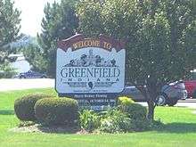
Greenfield, Indiana
| City of Greenfield, Indiana | |
|---|---|
| City | |
|
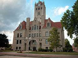
Hancock County Courthouse in downtown Greenfield. | |
 Location in the state of Indiana | |
| Coordinates: 39°47′29″N 85°46′17″W / 39.79139°N 85.77139°WCoordinates: 39°47′29″N 85°46′17″W / 39.79139°N 85.77139°W | |
| Country | United States |
| State | Indiana |
| County | Hancock |
| Government | |
| • Mayor | Chuck Fewell[1] R) |
| Area[2] | |
| • Total | 12.66 sq mi (32.79 km2) |
| • Land | 12.55 sq mi (32.50 km2) |
| • Water | 0.11 sq mi (0.28 km2) |
| Elevation | 883 ft (269 m) |
| Population (2010)[3] | |
| • Total | 20,602 |
| • Estimate (2012[4]) | 21,056 |
| • Density | 1,641.6/sq mi (633.8/km2) |
| Time zone | EST (UTC-5) |
| • Summer (DST) | EDT (UTC-4) |
| ZIP code | 46140 |
| Area code(s) | 317 |
| FIPS code | 18-29520[5] |
| GNIS feature ID | 0449837[6] |
| Website |
www |
Greenfield is a city in and the county seat of Hancock County, Indiana, United States,[7] and a part of the Indianapolis metropolitan area. The population was 20,602 at the 2010 census. It lies in Center Township.
Greenfield was a stop along the Pittsburgh, Cincinnati, Chicago and St. Louis Railroad that connected Pittsburgh to Chicago and St. Louis.
History
Hancock County was created on March 1, 1828, and named for John Hancock, the first person to sign the Declaration of Independence. The town of Greenfield was chosen as the county seat on April 11, 1828. The Commissioners announced, "The seat of Justice of Hancock County shall be known and designated by the name and title of Greenfield."[8] The population of the county at that time was 400.
Early settlers built along the two creeks which flow south through Center Township, which includes Greenfield. The first businesses were small grist mills for grinding corn and wheat for settlers.
U.S. Route 40, the National Road, was built through Hancock County around 1835. It was heavily traveled by wagon trains going west and livestock going to Cincinnati. In 1853, the first steam railroad was completed by the Indiana Central Railroad at the south edge of Greenfield. The railroad became part of the Pennsylvania Railroad System and later the Penn-Central. These tracks were removed in the 1980s.
During this time, Greenfield's population continued to grow. Greenfield was incorporated as a city in 1876 with a population of 2,023. The greatest single period of growth began in 1887 when natural gas was discovered in the area. Greenfield was a boom town for 20 years, with the founding of manufacturing plants and other industries.
A statue of James Whitcomb Riley, which stands in front of the Hancock County Courthouse, was erected in 1918. It was purchased with money donated by school children from all over the United States. Each year, during the Riley Festival in October, the city's school children parade to the statue to place flowers around it.
Charles Barr House, Greenfield Courthouse Square Historic District, Greenfield Residential Historic District, Lilly Biological Laboratories, Lincoln Park School, and James Whitcomb Riley House are listed on the National Register of Historic Places.[9][10]
Geography
Greenfield is located at 39°47′29″N 85°46′17″W / 39.79139°N 85.77139°W (39.791338, -85.771343).[11]
According to the 2010 census, Greenfield has a total area of 12.662 square miles (32.79 km2), of which 12.55 square miles (32.50 km2) (or 99.12%) is land and 0.112 square miles (0.29 km2) (or 0.88%) is water.[2]
Located on the east side of historic downtown lies Riley Park, in which flows the Brandywine River.
Demographics
| Historical population | |||
|---|---|---|---|
| Census | Pop. | %± | |
| 1860 | 744 | — | |
| 1870 | 1,203 | 61.7% | |
| 1880 | 2,013 | 67.3% | |
| 1890 | 3,100 | 54.0% | |
| 1900 | 4,489 | 44.8% | |
| 1910 | 4,448 | −0.9% | |
| 1920 | 4,168 | −6.3% | |
| 1930 | 4,188 | 0.5% | |
| 1940 | 4,821 | 15.1% | |
| 1950 | 6,159 | 27.8% | |
| 1960 | 9,049 | 46.9% | |
| 1970 | 9,986 | 10.4% | |
| 1980 | 11,288 | 13.0% | |
| 1990 | 11,657 | 3.3% | |
| 2000 | 14,600 | 25.2% | |
| 2010 | 20,602 | 41.1% | |
| Est. 2015 | 21,497 | [12] | 4.3% |
2010 census
As of the census[3] of 2010, there were 20,602 people, 7,983 households, and 5,382 families residing in the city. The population density was 1,641.6 inhabitants per square mile (633.8/km2). There were 8,818 housing units at an average density of 702.6 per square mile (271.3/km2). The racial makeup of the city was 96.6% White, 0.6% African American, 0.3% Native American, 0.8% Asian, 0.4% from other races, and 1.3% from two or more races. Hispanic or Latino of any race were 1.8% of the population.
There were 7,983 households of which 36.8% had children under the age of 18 living with them, 49.2% were married couples living together, 12.8% had a female householder with no husband present, 5.4% had a male householder with no wife present, and 32.6% were non-families. 26.8% of all households were made up of individuals and 10.8% had someone living alone who was 65 years of age or older. The average household size was 2.51 and the average family size was 3.04.
The median age in the city was 35.6 years. 26.4% of residents were under the age of 18; 8% were between the ages of 18 and 24; 28.7% were from 25 to 44; 23% were from 45 to 64; and 14% were 65 years of age or older. The gender makeup of the city was 48.1% male and 51.9% female.
2000 census
As of the census[5] of 2000, there were 14,600 people, 5,917 households, and 4,017 families residing in the city. The population density was 1,818.0 people per square mile (702.0/km²). There were 6,449 housing units at an average density of 803.0 per square mile (310.1/km²). The racial makeup of the city was 98.23% White, 0.05% African American, 0.21% Native American, 0.53% Asian, 0.01% Pacific Islander, 0.33% from other races, and 0.64% from two or more races. Hispanic or Latino of any race were 1.27% of the population.
There were 5,917 households out of which 32.8% had children under the age of 18 living with them, 53.4% were married couples living together, 10.7% had a female householder with no husband present, and 32.1% were non-families. 27.4% of all households were made up of individuals and 10.9% had someone living alone who was 65 years of age or older. The average household size was 2.41 and the average family size was 2.93.

In the city the population was spread out with 25.2% under the age of 18, 8.6% from 18 to 24, 30.9% from 25 to 44, 21.0% from 45 to 64, and 14.3% who were 65 years of age or older. The median age was 35 years. For every 100 females there were 92.3 males. For every 100 females age 18 and over, there were 87.6 males.
The median income for a household in the city was $72,035, and the median income for a family was $82,408. Males had a median income of $66,188 versus $56,568 for females. The per capita income for the city was $52,509. About 3.0% of families and 4.3% of the population were below the poverty line, including 4.7% of those under age 18 and 6.2% of those age 65 or over.
Government
The government consists of a mayor and a city council. The mayor is elected in citywide vote. The city council consists of seven members. Five are elected from individual districts. Two are elected at-large.
Education
Greenfield-Central Community School Corporation services the city of Greenfield and surrounding areas in central Hancock County. It consists of four elementary schools (Grades K - 3), two intermediate schools (Grades 4 - 6), one junior high school (Grades 7 - 8), and one high school (Grades 9 - 12). Greenfield Central High School was built in the late 2000s to accommodate Greenfield's rapidly growing population. Greenfield-Central High School also has undergone renovation in 2011.
- List of schools - Greenfield-Central Community School Corporation
- Eden Elementary School
- Harris Elementary School
- J.B. Stephens Elementary School
- Weston Elementary School
- Greenfield Intermediate School
- Maxwell Intermediate School
- Greenfield Central Jr. High School
- Greenfield-Central High School
St. Michael's School also serves Greenfield, offering Pre-kindergarten through Grade 8. It is a private Catholic School that won the Blue Ribbon Award.
Industry and commerce
Businesses with headquarters and/or significant operations in Greenfield include:
- Avery Dennison: manufactures a variety of adhesive labels and adhesive backed films.
- Covance: engaged in research, development, and testing of pharmaceutical products. This facility was operated by Eli Lilly and Company until 2008.[14]
- Cynthia's Hallmark Stores: operates four Hallmark retail stores in Central Indiana; the company's Greenfield location is the single largest in the U.S.[15]
- Elanco: a division of Eli Lilly and Company that manufactures animal health products, including feed additives and pet medicines.
- Hancock Regional Hospital is a full-service community hospital with a focus on primary care, patient comfort, and convenience.[16]
- Indiana Automotive Fasteners: manufactures fasteners for automotive OEMs including Toyota, Ford and Honda.
- Keihin Indiana Precision Technology: a subsidiary of Honda Motor that manufactures automotive components including intake manifolds, solenoid valves, and throttle bodies.
- Novelty, Inc.: the largest non-food distributor east of the Mississippi River markets and distributes novelty items for convenience stores.[17]
- Stanley Black & Decker: manufacture[s] industrial fasteners, various types of steel fasteners and industrial applications equipment and will assemble pneumatic tools.[18]
- University Loft Company - Furniture Manufacturing Company and Wholesale Sales
Sister and friendship cities
Greenfield is currently in a sister city relationship with Kakuda, Miyagi Prefecture, Japan. Each year, a small group of high school students from Greenfield and Kakuda are chosen to travel to each sister city, respectively, and will stay with a host family for ten days, most expenses paid, thanks to local donations. The sister city program began in 1990 and continues today.
Notable people
- Mark Dismore, Indy Racing League and Indianapolis 500 driver
- Ethan Edwards, classical saxophonist
- Kyle Gibson, 22nd Overall Pick in 2009 Major League Baseball Draft by Minnesota Twins
- Henry C. Gooding, Indiana State Senator and Arizona Territorial jurist
- Chad Hamilton, 1996 & 1997 Indiana State Karate Champion, 1998 PKC National Champion
- James Whitcomb Riley, poet and writer
- Jaycie Phelps, member of the US Women's gold medal winning 1996 Olympic Gymnastic Team
- Will Vawter, artist
Events
Each year in October, the city of Greenfield hosts the Riley Festival which is commonly known as Riley Days. The intersections of State Road 9 and US 40 are closed and the downtown courthouse square is filled with vendors and exhibitors.[19]
Media
- Radio Station WRGF 89.7 FM.
- Daily Reporter - daily newspaper[20]
References
- ↑ Tyler Rankins (1943-07-15). "Mayor Chuck Fewell". Greenfieldin.org. Retrieved 2016-07-16.
- 1 2 "G001 - Geographic Identifiers - 2010 Census Summary File 1". United States Census Bureau. Retrieved 2015-07-28.
- 1 2 "American FactFinder". United States Census Bureau. Retrieved 2012-12-11.
- ↑ "Population Estimates". United States Census Bureau. Archived from the original on 2013-06-17. Retrieved 2013-06-25.
- 1 2 "American FactFinder". United States Census Bureau. Archived from the original on 2013-09-11. Retrieved 2008-01-31.
- ↑ "US Board on Geographic Names". United States Geological Survey. 2007-10-25. Retrieved 2008-01-31.
- ↑ "Find a County". National Association of Counties. Archived from the original on 2015-05-10. Retrieved 2011-06-07.
- ↑ Binford, John H. (1882). History of Hancock County, Indiana: From Its Earliest Settlement by the "pale Face," in 1818, Down to 1882 ... King & Binford, publishers. p. 174.
- ↑ National Park Service (2010-07-09). "National Register Information System". National Register of Historic Places. National Park Service.
- ↑ "National Register of Historic Places Listings". Weekly List of Actions Taken on Properties: 12/12/11 through 12/16/11. National Park Service. 2011-12-23.
- ↑ "US Gazetteer files: 2010, 2000, and 1990". United States Census Bureau. 2011-02-12. Retrieved 2011-04-23.
- ↑ "Annual Estimates of the Resident Population for Incorporated Places: April 1, 2010 to July 1, 2015". Census.gov. Retrieved July 2, 2016.
- ↑ "Census of Population and Housing". Census.gov. Archived from the original on May 11, 2015. Retrieved June 4, 2015.
- ↑ "Lilly Sells its Greenfield, Indiana, Operations to Covance; Expands Existing Collaboration Between the Two Companies (NYSE:LLY)". Newsroom.lilly.com. 2008-08-06. Retrieved 2016-07-16.
- ↑ Home. "Cynthia's Hallmark | & Boutique". Cynthiashallmarkstores.com. Retrieved 2016-07-16.
- ↑ "Archived copy". Archived from the original on 2010-11-05. Retrieved 2010-11-09.
- ↑ "Archived copy". Archived from the original on 2012-03-08. Retrieved 2011-02-24.
- ↑ "Entry Details View". IN.GOV. Retrieved 2016-07-16.
- ↑ "Riley Festival: Greenfield, Indiana". Rileyfestival.com. Retrieved 2016-07-16.
- ↑ http://www.greenfieldreporter.com
External links
Municipalities and communities of Hancock County, Indiana, United States | ||
|---|---|---|
| City | ||
| Towns | ||
| Townships | ||
| Unincorporated communities |
| |
| Footnotes | ‡This populated place also has portions in an adjacent county or counties | |