Ariah Park
| Ariah Park New South Wales | |
|---|---|
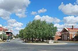 Coolamon Street, the main street of Ariah Park | |
|
Ariah Park | |
| Coordinates | 34°19′0″S 147°13′0″E / 34.31667°S 147.21667°ECoordinates: 34°19′0″S 147°13′0″E / 34.31667°S 147.21667°E |
| Population | 268 (2011 census)[1] |
| Postcode(s) | 2665 |
| Elevation | 316 m (1,037 ft) |
| Location |
|
| LGA(s) | Temora Shire |
| County | Bourke |
| State electorate(s) | Cootamundra |
| Federal Division(s) | Riverina |
Ariah Park /ˈɛəriə ˈpɑːrk/ is a small town in the Riverina region of New South Wales, Australia, 35 kilometres (22 mi) west of Temora and 65 kilometres (40 mi) south of West Wyalong. The town is within the Temora Shire near Burley Griffin Way. On Census night 2011, Ariah Park had a population of 268 people.[1] The town is listed by the National Trust as a Conservation Area.
The town's name came from resident Sam Harrison who purchased a portion of the Wellman Estate and then named that portion Ariah Park (pronounced 'area').[3]
Tourist information make reference to the town being known for its 'wowsers, bowsers and peppercorn trees'. A wowser is an Australian word describing a "mealy-mouthed hypocrite, a pious prude, one who condemns or seeks to curtail the pleasures of others or who works to have his or her own rigid morality enforced on all who prefers not to consume alcohol". A bowser refers to the everyday machine used to pump petrol or diesel into a vehicle, of which many antique examples can be seen on the main street. The peppercorn tree is a common variety of which many specimens populate the main street.
The settlement was first established in 1850.[4] Ariah Park was connected to the Main Southern railway line via Temora in 1906.[5] The village was gazetted the year after this connection and flourished at the expense of the nearby settlement of Broken Dam. Ariah Park Post Office had opened earlier on 26 August 1903.[6] The peppercorn trees were planted in 1916 and railway silos built in 1919.[4]
The district produces sheep and wheat. New South Wales Government Railways launched its first bulk-wheat loading operation in the town in 1916.[7]
-
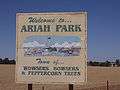
Entering Ariah Park
-
.jpg)
One side of the main street of Ariah Park - note the peppercorn trees
-
.jpg)
The other side of the main street - note the bowsers
-
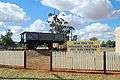
First bulk wheat handling truck from 1916
-
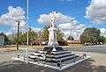
War memorial
-

Ariah Park Hotel, built in 1916
Notable residents
- William Maitland Woods, Anglican minister at Ariah Park from 1913 to 1915 and Australian Army chaplain in World War I
See also
References
- 1 2 Australian Bureau of Statistics (31 October 2012). "Ariah Park (L) (Urban Centre/Locality)". 2011 Census QuickStats. Retrieved 5 November 2012.
- ↑ Travelmate
- ↑ "Ariah Park". Geographical Names Register (GNR) of NSW. Geographical Names Board of New South Wales.
- 1 2 "Ariah Park - Wowsers, Bowsers and Peppercorn Trees". Attractions. Temora Shire Council. 2005. Archived from the original on 20 August 2006. Retrieved 2 February 2007.
- ↑ NSWrail.net - Temora Roto line and NSWrail.net page on Ariah Park with photos of railway station
- ↑ Premier Postal History. "Post Office List". Retrieved 11 June 2009.
- ↑ "First Bulk Wheat Haulage". History. Temora Shire Council. 2004. Archived from the original on 21 August 2006. Retrieved 2 February 2007.
External links
![]() Media related to Ariah Park at Wikimedia Commons
Media related to Ariah Park at Wikimedia Commons