Darbalara, New South Wales
| Darbalara New South Wales | |
|---|---|
 Darbalara | |
|
Darbalara | |
| Coordinates | 35°02′S 148°13′E / 35.033°S 148.217°ECoordinates: 35°02′S 148°13′E / 35.033°S 148.217°E |
| Postcode(s) | 2722 |
| Elevation | 303 m (994 ft) |
| Location | |
| LGA(s) | Gundagai Shire Council |
| County | Buccleuch |
| State electorate(s) | Cootamundra |
| Federal Division(s) | Riverina |
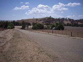
Darbalara is a rural community on east bank of the junction of the Murrumbidgee River and Tumut River in the Riverina. It is situated by road, about 25 kilometres north east from Gundagai and 25 kilometres south from Coolac.
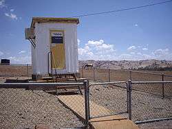
Darbalara telephone exchange
There are no public buildings in Darbalara other than the telephone exchange. A number of properties running sheep and cattle are located in the area.
Darbalara Post Office opened on 25 April 1912 and closed in 1962.[1]
Notes and references
- ↑ Premier Postal History, Post Office List, retrieved 2009-06-11
| Wikimedia Commons has media related to Darbalara, New South Wales. |
This article is issued from Wikipedia - version of the 5/7/2016. The text is available under the Creative Commons Attribution/Share Alike but additional terms may apply for the media files.