Brocklesby, New South Wales
| Brocklesby New South Wales | |
|---|---|
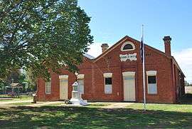 Brocklesby School of Arts, 1907 | |
|
Brocklesby | |
| Coordinates | 35°48′S 146°41′E / 35.800°S 146.683°ECoordinates: 35°48′S 146°41′E / 35.800°S 146.683°E |
| Population | 238 (2006 census)[1] |
| Postcode(s) | 2642 |
| Elevation | 250 m (820 ft) |
| Location |
|
| LGA(s) | Greater Hume Shire |
| County | Mayor = Gary Drew |
| State electorate(s) | Albury |
| Federal Division(s) | Farrer |
Brocklesby /ˈbrɒkəlzbi/ is a town in the Riverina region of south west New South Wales, Australia. The town is in the Greater Hume Shire Council local government area, 45 kilometres (28 mi) north-west of the regional centre of Albury. In the 2006 census Brocklesby had a population of 238.[1]
Brocklesby, although having only a very small population prides itself on having an active community, including a long-standing pigeon club.(The pigeon shed was taken down in 2011.) Town buildings include the public hall, a recreation reserve, local primary school and pre-school, and since 2000, a public hotel which is owned by the Greater Hume Shire Council and operating under a community licence.
Historical significance
Brocklesby village was once a main railway centre used for the transportation of grain. Nowadays the grain silos are all that remain and grain is transported by road truck. The area is now characterised by sheep, cattle and grain farmland.
Tom Roberts painted his celebrated masterpiece Shearing the Rams at "Brocklesby" Station at nearby Corowa.[3]
Brocklesby Post Office opened on 29 April 1893.[4] Brocklesby Shop opened in mid-2010.
Former St. Kilda AFL player Justin Koschitzke hails from Brocklesby.
Avro Anson plane crash
The area is also known for a historical emergency landing of two twin-engine Avro Anson training planes which collided overhead and became entangled with one plane sitting on top of the other. The two crew members of the lower plane parachuted to safety whilst Leading Aircraftsman Leonard Fuller, the pilot of the top plane undertook a daring and heroic flight of 8 kilometres before belly landing the two planes single-handed in a paddock approximately 4 kilometres (2 mi) from the town.[5]
Gallery
 Shearing the Rams (1890) by Tom Roberts
_%22piggyback%22_in_a_paddock_near_Brocklesby_2.jpg) Two Avro Ansons (L9162 and N4876) "piggyback"
Two Avro Ansons (L9162 and N4876) "piggyback"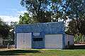 Brocklesby pigeon club
References
- 1 2 Australian Bureau of Statistics (25 October 2007). "Brocklesby (State Suburb)". 2006 Census QuickStats. Retrieved 23 June 2009.
- ↑ Travelmate Archived March 25, 2007, at the Wayback Machine.
- ↑ Tom Roberts & Brocklesby link
- ↑ Premier Postal History, Post Office List, retrieved 2009-06-11
- ↑ Avro Anson plane crash including images
External links
![]() Media related to Brocklesby, New South Wales at Wikimedia Commons
Media related to Brocklesby, New South Wales at Wikimedia Commons