Hume Dam
| Hume Dam | |
|---|---|
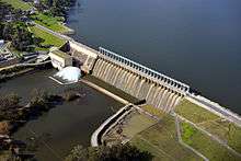 Aerial view of Hume Dam and spillway, 2012 | |
 Location of the Hume Dam in New South Wales | |
| Country | Australia |
| Location | Riverina, New South Wales |
| Coordinates | 36°06′30″S 147°01′52″E / 36.10833°S 147.03111°ECoordinates: 36°06′30″S 147°01′52″E / 36.10833°S 147.03111°E |
| Purpose | Flood mitigation, hydro-power, irrigation, water supply and conservation |
| Status | Operational |
| Construction began | 1919 |
| Opening date | 1936 |
| Construction cost | A£2.1 million[1] |
| Owner(s) | Murray-Darling Basin Authority |
| Dam and spillways | |
| Type of dam | Gravity dam |
| Impounds | Murray River |
| Height | 51 metres (167 ft) |
| Length | 1,615 metres (5,299 ft) |
| Spillways | 29 |
| Spillway type | Vertical undershot gated concrete overflow |
| Spillway capacity | 7,929 cubic metres per second (280,000 cu ft/s) |
| Reservoir | |
| Creates | Lake Hume |
| Total capacity | 3,036,500 megalitres (2,461,700 acre·ft) |
| Active capacity | 1,417,188 megalitres (1,148,933 acre·ft) |
| Inactive capacity | 1,619,312 megalitres (1,312,798 acre·ft) |
| Catchment area | 15,300 square kilometres (5,900 sq mi) |
| Surface area | 20,190 hectares (49,900 acres) |
| Max. water depth | 40 metres (130 ft) |
| Normal elevation | 192 metres (630 ft) AHD |
| Power station | |
| Operator(s) | Eraring Energy |
| Commission date | 1957 |
| Type | Conventional |
| Turbines | 2 |
| Installed capacity | 58 megawatts (78,000 hp) |
| Annual generation | 220 gigawatt-hours (790 TJ) |
|
Website Hume Dam at www.statewater.com.au | |
Hume Dam, formerly the Hume Weir, is a major dam across the Murray River downstream of its junction with the Mitta River in the Riverina region of New South Wales, Australia. The dam's purpose includes flood mitigation, hydro-power, irrigation, water supply and conservation. The impounded reservoir is called Lake Hume, formerly the Hume Reservoir. It is a gated concrete gravity dam with four earth embankments and twenty-nine vertical undershot gated concrete overflow spillways.
Location
Constructed over a 17-year period between 1919 and 1936,[2] the Hume Dam is located approximately 27 kilometres (17 mi) east of the city of Albury. The dam was built, involving a workforce of thousands, by a consortium of NSW and Victorian government agencies that included the Water Resources Commission of New South Wales, the Public Works Department of New South Wales, and the State Rivers and Water Supply Commission of Victoria.[3] Supplies to the construction site were delivered via rail, through the construction of a branch siding from the Wodonga - Cudgewa railway. Hume Dam is jointly managed by Victorian and New South Wales authorities on behalf of the Murray-Darling Basin Authority. Goulburn-Murray Water manages water and land located in Victoria, and the New South Wales State Water Corporation is responsible for day-to-day operation and maintenance and the management of major remedial works at the dam.[4]
Description
The dam is a mix of a concrete gravity dam with four earth embankments. The dam wall height is 51 metres (167 ft) and the crest is 1,615 metres (5,299 ft) long with the auxiliary embankments extending a further 1,010 metres (3,310 ft). The maximum water depth is 40 metres (130 ft) and at 100% capacity the dam wall holds back 3,005,157 megalitres (106,126.1×106 cu ft) of water at 192 metres (630 ft) AHD. The surface area of Lake Hume is 20,190 hectares (49,900 acres) and the catchment area is 15,300 square kilometres (5,900 sq mi). The dam wall is constructed of rock covered with clay and other earth and is designed to carry vehicular traffic. A controlled concrete spillway that comprises a gated concrete overflow, with twenty-nine vertical undershot gates, is capable of discharging 7,929 cubic metres per second (280,000 cu ft/s).[5][6]
Water is retained nearly 40 kilometres (25 mi) upstream of the reservoir in the valleys of both the Murray and Mitta Mitta rivers.
The dam wall was extended during the 1950s, and completed in 1961,[6] necessitating the wholesale removal of Tallangatta township and its re-establishment at a new site 8 kilometres (5.0 mi) west of the original, as well as railway and road diversions. Monitoring of the dam in the early 1990s revealed that the water pressure and leakage had caused the dam to move on its foundations slightly, leading to concerns that the dam was heading for collapse, threatening Albury-Wodonga and the entire Murray basin. Authorities denied any short-term threat. Traffic was banned from the spillway, and remedial work commenced involving, in part, the construction of a secondary earth wall behind the original to take the strain. Further upgrades to the dam at an estimated cost of A$60 million commenced in 2010 and are due for completion in 2015. These works include the installation of an improved filter and drainage system on the junction between the concrete spillway and southern embankment, construction of a concrete buttress on the southern training wall, and possible modifications to improve the ability of the dam to manage extreme floods.[7]
Power station

The Hume Power Station is a 58 megawatts (78,000 hp) hydro-electric power station installed in the dam wall, and is primarily used for peak-load generation. The station has an average annual output of 220 gigawatt-hours (790 TJ).[3] The power station comprises two 29 megawatts (39,000 hp) turbines and is operated by Eraring Energy. In October 2012, a high voltage transformer at the power station caught fire, requiring more than fifty fire fighters who worked into the long hours of the night to put out the blaze.[8][9]
The power station was completed in 1957, running two 25 megawatts (34,000 hp) turbines. In 2000, these turbines were each upgraded to 29 megawatts (39,000 hp).[10][11]
In October 2012, a high voltage transformer at the power station caught fire, requiring more than 50 fire fighters who worked late into the night to put out the blaze.[8][12]
Etymology
Originally named the Mitta Mitta Dam site, following representations from the Municipal Council of Albury, on 17 February 1920 the River Murray Commission decided to honour Hamilton Hume, who, in company with William Hovell, was one of the first Europeans to see and cross the Murray River in 1824. In 1920, the reservoir was named the Hume Reservoir and the dam adopted the name of the Hume Weir, the name given by the Victorian Place Names Committee. Following a proposal from Hume Shire Council, in 1996 both the NSW and Victorian governments agreed that the dam should be named the Hume Dam,[2][4] and the reservoir be named Lake Hume.[13]
Lake Hume

Lake Hume is estimated to hold approximately six times the volume of water in Sydney Harbour.[5] The small towns of Tallangatta, Bonegilla and Bellbridge are located on the shores of Lake Hume. The reservoir is often referred to as the Hume Weir, only named Lake Hume in the mid-1980s.
Reservoir levels
Lake Hume is the furthest upstream of the major reservoirs on the Murray River system and has the capacity to release water at the fastest rate. Irrigation authorities used the reservoir as the storage of first resort. The reservoir typically falls to less than one-third capacity by March each year, but in normal years refills to at least two-thirds capacity before November, though Australia's highly unpredictable climatic conditions cause these figures to vary quite significantly from year to year.[4] In 2007 Lake Hume fell to 1% capacity, barely more than the water in the Murray and Mitta Mitta rivers flowing through on their original paths. Between 2010 and April 2013, the lowest storage level was in the range of 500,000 megalitres (18,000×106 cu ft).[14]
Recreation
The lake is stocked with fish. Most of these are introduced species - carp, redfin and trout though native species such as Golden Perch and Murray Cod can also be found. The fishing varies from year to year. It is also popular for water skiing, and several holiday resorts catering for fishing and skiers are dotted around the upper reaches of the lake.[5]
See also
- Eraring Energy
- Hume Power Station
- Hume Weir Motor Racing Circuit
- Irrigation in Australia
- List of dams and reservoirs in New South Wales
Gallery
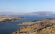
 Lake Hume, as seen from the New South Wales border, 2012.
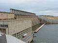 The dam wall.
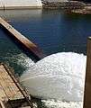 Outflow in April 2014.
 Hume Dam panorama, April 2009
References
- ↑ "£2m. Hume Weir Power Station". The Advertiser. National Library of Australia. 27 January 1949. p. 1. Retrieved 19 April 2013.
- 1 2 "Hume Dam". Geographical Names Register (GNR) of NSW. Geographical Names Board of New South Wales. Retrieved 19 April 2013.
- 1 2 "Register of Large Dams in Australia" (Excel (requires download)). Dams information. The Australian National Committee on Large Dams Incorporated. 2010. Retrieved 16 April 2013.
- 1 2 3 "Hume Dam". Water Resources: Water Storages: Murray. Goulburn-Murray Water. 2013. Retrieved 19 April 2013.
- 1 2 3 "Hume Dam" (PDF brochure). State Water Corporation. 2009. Retrieved 19 April 2013.
- 1 2 "Hume Dam". Water delivery: dams. State Water Corporation. Retrieved 19 April 2013.
- ↑ "Hume Dam upgrade works". Projects: Dam safety upgrades. State Water Corporation. Retrieved 19 April 2013.
- 1 2 Smethurst, Annika (14 October 2012). "Fire blazes at Lake Hume Power Station". Herald Sun. Retrieved 19 April 2013.
- ↑ McNay, Nigel (15 October 2012). "Smoke on the water: Hume Weir fire". The Border Mail. Retrieved 19 April 2013.
- ↑ "Hume". Generation Portfolio: Hydro Power Stations. Eraring Energy. 18 April 2013. Retrieved 19 April 2013.
- ↑ AEMO Registration List
- ↑ McNay, Nigel (15 October 2012). "Smoke on the water: Hume Weir fire". The Border Mail. Retrieved 19 April 2013.
- ↑ "Lake Hume". Geographical Names Register (GNR) of NSW. Geographical Names Board of New South Wales. Retrieved 19 April 2013.
- ↑ "Hume Dam: Historical Water Storage Data". Water Resources: Water Storages: Murray. Goulburn-Murray Water. April 2013. Retrieved 19 April 2013.
External links
| Wikimedia Commons has media related to Lake Hume. |
- "Murray River catchment (NSW)" (map). Office of Environment and Heritage. Government of New South Wales.
- "Hume Dam Hydro-Electric Development (Construction) Act" (PDF). Parliament of New South Wales. 1950.
- "Lake Hume". Land on Water Management. 2013.
- "Hume Dam". River Murray system. Murray-Darling Basin Commission. 16 June 2009.
- "Hume Dam". Nomination for a National Engineering Landmark. Institution of Engineers, Australia. June 2002.