Springdale, New South Wales
| Springdale New South Wales | |
|---|---|
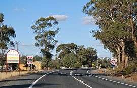 Entering Springdale | |
|
Springdale | |
| Coordinates | 34°27′S 147°43′E / 34.450°S 147.717°ECoordinates: 34°27′S 147°43′E / 34.450°S 147.717°E |
| Postcode(s) | 2666 |
| Location |
|
| LGA(s) | Temora Shire |
| County | Bland |
| State electorate(s) | Cootamundra |
| Federal Division(s) | Riverina |
Springdale is a village community in the central north part of the Riverina region of the Australian state of New South Wales.[1] It is situated by road, about 3 kilometres east from Combaning and 23 kilometres north west from Stockinbingal.
Springdale Post Office opened on 1 November 1897 and closed in 1977.[2] A railway station on the branch line to Lake Cargelligo served the community between 1893 and 1975.[3]
Gallery
 Springdale Functions Hall
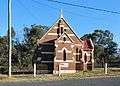 All Saints Anglican church
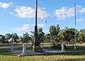 War memorial
Springdale railway station
| Preceding station | NSW Branch lines | Following station | ||
|---|---|---|---|---|
Temora towards Lake Cargelligo | Lake Cargelligo Line | Gundibindyal towards Cootamundra |
References
- ↑ "Springdale". Geographical Names Register (GNR) of NSW. Geographical Names Board of New South Wales.
- ↑ Premier Postal History, Post Office List, retrieved 2009-06-11
- ↑ Combaning station. NSWrail.net, accessed 6 September 2009.
| Wikimedia Commons has media related to Springdale, New South Wales. |
This article is issued from Wikipedia - version of the 4/2/2015. The text is available under the Creative Commons Attribution/Share Alike but additional terms may apply for the media files.