Tumbarumba
| Tumbarumba New South Wales | |
|---|---|
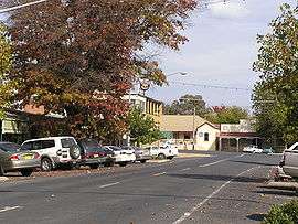 The Parade, Main street of Tumbarumba | |
|
Tumbarumba | |
| Coordinates | 35°47′0″S 148°01′0″E / 35.78333°S 148.01667°ECoordinates: 35°47′0″S 148°01′0″E / 35.78333°S 148.01667°E |
| Population | 1,487 (2006 census)[1] |
| Established | 1850s |
| Postcode(s) | 2653 |
| Elevation | 645 m (2,116 ft) |
| Location |
|
| LGA(s) | Snowy Valleys Council |
| County | Selwyn |
| State electorate(s) | Albury |
| Federal Division(s) | Eden-Monaro |
Tumbarumba (/tʌmbəˈrʌmbə/[2] tum-bə-RUM-bə) is a small town in New South Wales, Australia, about 480 kilometres (300 mi) southwest of the state capital, Sydney. Tumbarumba is located on the periphery of the Riverina and South West Slopes regions at the western edge of the Snowy Mountains. The 2011 census showed the population of the town to 1455 people, a decline from 1,487 people living there in 2006.[1] Locals refer to the town as 'Tumba'.
To the south and east, the highest peak of the Snowy Mountains and mainland Australia—Mount Kosciuszko—can be seen.
History
The community was established in the late 1850s after gold was discovered in the district. The Post Office opened on 1 August 1860 but was spelt Tumberumba until 1915.[3]
A railway branch line was opened to Tumbarumba in 1921. The Tumbarumba railway line ran from Wagga Wagga through Tarcutta. The service has been suspended since 1987.
Gold mining petered out in the 1930s, and the region's economy now depends on agriculture and tourism. The timber industry dominates the Shire’s economy.
The name Tumbarumba may be derived from Wiradjuri dhamba dhamba, meaning "very soft"[4] or alternatively from the Aboriginal words for "hollow sounding ground", "thunder", "sound" or "place of big trees".[5]
Industry
The major industry in the town is softwood timber processing, with the Hyne and Sons Timber Mill to the west of the town being the biggest employer.[6] Other industries include tourism, viticulture (Tumbarumba is in the Tumbarumba wine region), and blueberry growing. Tourism is a source of income due to its proximity to the snow fields.[7]
Tourism
Tumbarumba provides a convenient base for visiting the Western Snowy Mountains area.
The town lies on the Snowy Valleys Way which Destination NSW[8] advertises as a more leisurely and picturesque driving route to take between Sydney and Melbourne. The Snowy Valleys way links Gundagai and Beechworth passing through Tumut, Tumbarumba and Corryong.
Tumbarumba is also close to the 440 km Hume and Hovell Track.[9] Access to the track is at the Henry Angel Trackhead, 9 km from Tumbarumba toward Khancoban. A half day walk from the Henry Angel Trackhead to 'Big Hill' provides spectacular views of the western face of the Snowy Mountains Main Range. This walk passes old gold workings at the Burra Falls.
Tumbarumba is also the centre for the Tumbarumba wine region, a developing cool climate wine growing region with the first plantings in 1982. Several local wineries have 'cellar doors' with wines for sale.
The Museum and Visitor Information Centre on Bridge Street is open 363 days of the year, and the Tumbarumba Library and Archive on Prince Street is open Monday to Saturday, but check for opening hours.
Education
There are three schools in Tumbarumba. Tumbarumba Public School and All Saints Primary School (Catholic) providing primary education. Tumbarumba High School provides secondary education to the district.
Events
- The Tumbarumba Rodeo is held annually at the Tumbarumba Showground on New Years Day (1 January).
- Tumbafest - Annual weekend long music, wine and market festival held on the last weekend in February. Past festivals have attracted significant headline acts, including Leo Sayer (in 2015).
- Tumbarumba Tastebuds - a celebration of local food, wine and art. Held in the Spring.
Cultural references
- In November 1963, New Zealander Johnny Devlin (with Bee Gees on backing vocals) released the single "Stomp The Tumbarumba",[10] a song covered later by, among others, the Australian rock band Hoodoo Gurus (see "Come Anytime" and "1000 Miles Away"). Tumbarumba in the song's title may or may not have something to do with the name of the town.
- Tumbarumba is one of the very few Australian placenames mentioned in James Joyce's prose-poem Finnegans Wake. 'Tumbarumba mountain' is listed as one of the places of origin of HCE (Humphrey Chimpden Earwicker), one of the central characters of the Wake (FW 596.11).
- Shirley Abicair, the UK based Australian singer, made the town of Tumbarumba's name familiar to many British children with the publication of her book "Tales of Tumbarumba" in 1962.
- Tumbarumba is another word for a tmesis, a linguistic term which refers to the placing of a word within another word, such as "ri-goddamn-diculous". The origin of this meaning may come from the poem "Tumba-bloody-rumba" by John O'Grady, which includes several tmeses including "Tumba-bloody-rumba", "e-bloody-nough", and "kanga-bloody-roos".
Climate
Tumbarumba has an oceanic climate (Cfb). Frosts are frequent and snowfall is by no means unknown in the winter: the lowest recorded maximum temperature was 1.1 °C (34.0 °F) on 15 July 1966 and the coldest recorded minimum temperature was −10.4 °C (13.3 °F) on 22 June 1989. The hottest recorded maximum is 40.2 °C (104.4 °F) on 7 February 2009.
| Climate data for Tumbarumba Post Office | |||||||||||||
|---|---|---|---|---|---|---|---|---|---|---|---|---|---|
| Month | Jan | Feb | Mar | Apr | May | Jun | Jul | Aug | Sep | Oct | Nov | Dec | Year |
| Record high °C (°F) | 40.0 (104) |
40.2 (104.4) |
35.6 (96.1) |
29.4 (84.9) |
23.8 (74.8) |
19.1 (66.4) |
20.0 (68) |
22.0 (71.6) |
27.8 (82) |
31.5 (88.7) |
36.6 (97.9) |
37.3 (99.1) |
40.2 (104.4) |
| Average high °C (°F) | 28.8 (83.8) |
28.3 (82.9) |
25.0 (77) |
19.9 (67.8) |
15.2 (59.4) |
11.7 (53.1) |
10.6 (51.1) |
12.2 (54) |
15.2 (59.4) |
19.3 (66.7) |
22.6 (72.7) |
25.9 (78.6) |
19.6 (67.3) |
| Average low °C (°F) | 12.0 (53.6) |
12.0 (53.6) |
8.7 (47.7) |
4.9 (40.8) |
2.3 (36.1) |
0.2 (32.4) |
−0.2 (31.6) |
0.9 (33.6) |
3.0 (37.4) |
5.2 (41.4) |
7.6 (45.7) |
9.5 (49.1) |
5.5 (41.9) |
| Record low °C (°F) | 1.6 (34.9) |
1.9 (35.4) |
−1.3 (29.7) |
−4.1 (24.6) |
−6.7 (19.9) |
−10.4 (13.3) |
−9.4 (15.1) |
−8.1 (17.4) |
−5.0 (23) |
−5.5 (22.1) |
−3.9 (25) |
0.1 (32.2) |
−10.4 (13.3) |
| Average precipitation mm (inches) | 62.0 (2.441) |
54.9 (2.161) |
66.8 (2.63) |
65.7 (2.587) |
82.0 (3.228) |
102.0 (4.016) |
105.1 (4.138) |
107.2 (4.22) |
91.0 (3.583) |
96.5 (3.799) |
74.9 (2.949) |
70.8 (2.787) |
978.7 (38.531) |
| Average precipitation days | 6.0 | 5.6 | 6.3 | 7.2 | 9.4 | 12.1 | 13.1 | 13.2 | 11.4 | 10.3 | 8.2 | 7.3 | 110.1 |
| Average relative humidity (%) | 63 | 70 | 74 | 77 | 87 | 90 | 90 | 83 | 75 | 66 | 67 | 61 | 75 |
| Source: Australian Bureau of Meteorology[11] | |||||||||||||
Sport
Tumbarumba Greens fields a rugby league team in the Group 9 competition and the Tumbarumba Kangaroos compete in the Victorian-based Upper Murray Football League.
Gallery
 Aerial view from the southeast
 Tumbarumba District Roll of Honour
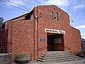 Tumbarumba Memorial Hall
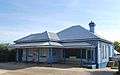 Post office
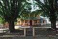 Court house
See also
References
- 1 2 Australian Bureau of Statistics (25 October 2007). "Tumbarumba (Urban Centre/Locality)". 2006 Census QuickStats. Retrieved 2008-03-31.
- ↑ Butler, Susan, ed. (2009). Macquarie Dictionary (5th ed.). Sydney: Macquarie Dictionary Publishers Pty Ltd. 1952 pages. ISBN 978-1-876-42966-9.
- ↑ Premier Postal History. "Post Office List". Retrieved 2008-04-11.
- ↑ McNicol, Sally; Hosking, Dianne (1994). "Wiradjuri". Macquarie Aboriginal Words. Sydney: Macquarie Library. p. 98.
- ↑ "Tumbarumba". Geographical Names Register (GNR) of NSW. Geographical Names Board of New South Wales. Retrieved 4 August 2013.
- ↑ Jeppe Nielsen (June 2008). "Tumbarumba Integrated Water Cycle Management Strategy" (PDF). p. 19. Retrieved 2010-01-21.
- ↑ "Tumbarumba" (PDF). Country Change Bureau. Retrieved 2010-01-21.
- ↑ "Snowy Valleys Way". Destination NSW. Retrieved 2016-05-26.
- ↑ "Snowy Valleys Way". NSW Department of Trade and Investment. Retrieved 2014-10-31.
- ↑ Bee Gees Recordings
- ↑ "Climate statistics for Australian locations". Australian Bureau of Meteorology. Retrieved 2013-04-15.
External links
![]() Media related to Tumbarumba, New South Wales at Wikimedia Commons
Media related to Tumbarumba, New South Wales at Wikimedia Commons
- Tumbarumba Shire Council
- Demographic profile of Tumbarumba Shire in 2001
- Discussion on Lost Poetry web site of authorship of the poem Tumba-bloody-rumba
- Tumbarumba Railway Station
- Tumbafest website