Collingullie
| Collingullie New South Wales | |
|---|---|
 General Store at Collingullie | |
|
Collingullie | |
| Coordinates | 35°5′19″S 147°7′44″E / 35.08861°S 147.12889°ECoordinates: 35°5′19″S 147°7′44″E / 35.08861°S 147.12889°E |
| Population | 399 (2006 census)[1] |
| Postcode(s) | 2650 |
| Location |
|
| LGA(s) | City of Wagga Wagga |
| County | Mitchell |
| State electorate(s) | Wagga Wagga |
| Federal Division(s) | Riverina |
Collingullie /ˈkɒlɪn.ɡʌli/ is a village 26 kilometres (16 mi) north-west of Wagga Wagga in the Riverina region of New South Wales, Australia. The village is located on the Sturt Highway, between Wagga Wagga and Narrandera, at the crossroads with the road to Lockhart.
At the 2006 census, Collingullie had a population of 399 people.[1] The name, Collingullie, could have derived from an Aboriginal word meaning 'boggy ground'.[3]
Collingullie Post Office opened on 1 August 1879 and closed in 1982.[4] The town's school, Collingullie Public School which has 56 students, is located on Urana Street.[5]
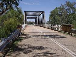
Bridge over Murrumbidgee River on Millwood to Collingullie road

CollingulliePark
References
- 1 2 Australian Bureau of Statistics (25 October 2007). "Collingullie (State Suburb)". 2006 Census QuickStats. Retrieved 12 July 2009.
- ↑ Travelmate Archived March 25, 2007, at the Wayback Machine.
- ↑ "Collingullie". Geographical Names Register (GNR) of NSW. Geographical Names Board of New South Wales. Retrieved 12 July 2009.
- ↑ Premier Postal History. "Post Office List". Retrieved 2009-06-11.
- ↑ "Collingullie Public School". New South Wales Public Schools. Retrieved 2009-07-17.
External links
![]() Media related to Collingullie at Wikimedia Commons
Media related to Collingullie at Wikimedia Commons
This article is issued from Wikipedia - version of the 11/28/2016. The text is available under the Creative Commons Attribution/Share Alike but additional terms may apply for the media files.