Mirrool
| Mirrool New South Wales | |
|---|---|
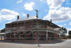 Mirrool (Royal) Hotel | |
|
Mirrool | |
| Coordinates | 34°17′16″S 147°5′42″E / 34.28778°S 147.09500°ECoordinates: 34°17′16″S 147°5′42″E / 34.28778°S 147.09500°E |
| Population | 234 (2011 census)[1] |
| Postcode(s) | 2665 |
| Elevation | 305 m (1,001 ft) |
| Location |
|
| LGA(s) | Bland Shire Council |
| County | Bourke |
| State electorate(s) | Cootamundra |
| Federal Division(s) | Riverina |
Mirrool is a town in the northern part of the Riverina region of south-west New South Wales, Australia. The town is in the Bland Shire local government area and adjacent to the Newell Highway, 473 kilometres (294 mi) south west of the state capital, Sydney. At the 2011 census, Mirrool and the surrounding area had a population of 234.[1]
The place name Mirrool is derived from the local Aboriginal word meaning "Pipe Clay".[2]
Mirrool Post Office opened on 16 November 1911 and closed in 1982.[3] A railway station opened with the opening of the railway line in 1908, and closed in 1985 after passenger services ceased in 1983.[4]
The town's pub was built between 1913 and 1916 and opened in 1917.[5] In recent times it was narrowly saved when a group of local farmers banded together to buy the licence just before it was sold off to Sydney (Liquor licences can be sold to another concern and then reinstated in a different location).
The town also has a football oval and —despite how far north Mirrool is in New South Wales— the style of football played in the town is Australian rules football. Every second Saturday in October the town holds a large gathering to which Australian Rules fans congregate to compete in the $1000 prize for kicking a football over the 32 metre silos that are situated opposite the pub. This event commenced in 1992 with the winner that year being Billy Brownless. The winner has been the silos on some occasions.[6]
Silo Kick Record
- 1992 - Billy Brownless
- 1993 - Silos
- 1994 - Rob Harper
- 1995 - Tim Hargreaves
- 1996 - Silos
- 1997 - Rob Harper
- 1998 - Daniel Chalmers
- 1999 - Rob Harper
- 2000 - Bruce Dickson Flint
- 2001 - N/A - Not Held
- 2002 - Rob Harper
- 2003 - Rob Harper
- 2004 - Rob Harper
- 2005 - Rob Harper
- 2006 - Rob Harper
- 2007 - Joel Fairman
- 2008 - Silos
- 2009 -
- 2010 -
- 2011 - Silos
Gallery
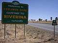 At the edge of Mirool there is a sign that indicates entry to the Riverina
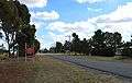 Entering Mirrool from the Newell Highway turnoff
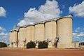 Mirrool silos
 Mirrool hosts a Silo Kick Competition every year in October
References
- 1 2 Australian Bureau of Statistics (31 October 2012). "Mirrool (State Suburb)". 2011 Census QuickStats. Retrieved 2 April 2015.
- ↑ "Mirrool". Geographical Names Register (GNR) of NSW. Geographical Names Board of New South Wales.
- ↑ Premier Postal History. "Post Office List". Retrieved 2009-06-11.
- ↑ Mirrool Station. NSWrail.net, accessed 10 November 2010.
- ↑ Judd, Nigel, ed. (2009). Mirrool 100 Years Young: A Collection of History From Mirrool and District. West Wyalong: Shire of Bland. p. 53. ISBN 978-0-9592746-1-5.
- ↑ Daffy, Paul (2002-10-13). "Where legends are made". The Age. Retrieved 2007-01-29.
External links
![]() Media related to Mirrool, New South Wales at Wikimedia Commons
Media related to Mirrool, New South Wales at Wikimedia Commons
| Preceding station | NSW Branch lines | Following station | ||
|---|---|---|---|---|
towards Roto | Temora- Roto Line | towards Temora |