Barton Heights
|
Town of Barton Heights Historic District | |
 | |
  | |
| Location | Roughly arton, Fendall, Greenwood, Lamb, Miller, Monterio, North, Rose, Dove, Home, Minor, Poe, Wellford, Wickham., Richmond, Virginia |
|---|---|
| Coordinates | 37°33′37″N 77°25′57″W / 37.56028°N 77.43250°WCoordinates: 37°33′37″N 77°25′57″W / 37.56028°N 77.43250°W |
| Area | 120 acres (49 ha) |
| Architectural style | Late Victorian, Late 19th And 20th Century Revivals |
| MPS | Streetcar Suburbs in Northside Richmond MPS |
| NRHP Reference # | 02000592[1] |
| VLR # | 127-0816 |
| Significant dates | |
| Added to NRHP | August 06, 2003 |
| Designated VLR | June 13, 2001[2] |
Barton Heights is a streetcar suburb neighborhood and former town in the Northside area of Richmond, Virginia. The area was primarily developed between 1890 and the 1920s.[3]
History
Begun as an area of development in Henrico County, Virginia in 1890 by James H. Barton, Barton Heights rapidly developed as the result of being linked via streetcar in 1894 across the deep ravine of the Bacon's Quarter branch of Shockoe Creek, which flows into the Shockoe Valley. The area incorporated as a town in 1896, and was annexed by the city of Richmond in 1914.[3]
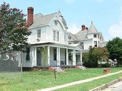
The Town of Barton Heights Historic District encompasses 367 contributing buildings (305 main buildings and 62 outbuildings). They are primarily spacious wood frame houses, most built in the first quarter of the 20th century, and sited on 50-foot-wide lots. The houses are largely built in the Queen Anne or Colonial Revival style.[3]
References
- ↑ National Park Service (2009-03-13). "National Register Information System". National Register of Historic Places. National Park Service.
- ↑ "Virginia Landmarks Register". Virginia Department of Historic Resources. Retrieved 19 March 2013.
- 1 2 3 Kimberly Merkel Chen; Mary Harding Sadler; Peter McDearmon Witt & Jean McRae (May 2003). "National Register of Historic Places Inventory/Nomination: Town of Barton Heights Historic District" (PDF). Virginia Department of Historic Resources. and Accompanying photo and Accompanying map
External links
 |
Ginter Terrace | Brookland Park | Highland Park | |
| Battery Park | |
Chestnut Hill (Southern Highland Park) | ||
| ||||
| | ||||
| North Jackson Ward (Gilpin) |

