Bhopawar Agency
| Bhopawar Agency | |||||
| Sub-agency of the Central India Agency | |||||
| |||||
 | |||||
| History | |||||
| • | Merger of Bhil Agency and Bhil Sub-agency | 1882 | |||
| • | Merger into Malwa Agency | 1937 | |||
| Area | |||||
| • | 1901 | 19,902 km2 (7,684 sq mi) | |||
| Population | |||||
| • | 1901 | 547,546 | |||
| Density | 27.5 /km2 (71.3 /sq mi) | ||||
| | |||||
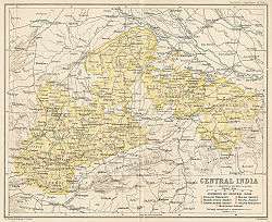
Bhopawar Agency was a sub-agency of the Central India Agency in British India with the headquarters at the town of Bhopawar, so the name. Bhopawar Agency was created in 1882 from a number of princely states in the Western Nimar and Southern Malwa regions of Central India belonging to the former Bhil Agency and Bhil Sub-agency with the capitals at Bhopawar and Manpur.[1] The agency was named after Bhopawar, a village in Sardarpur tehsil, Dhar District of present-day Madhya Pradesh state. Manpur remained a strictly British territory.
| Princely state |
|---|
| Individual residencies |
| Agencies |
|
| Lists |
|
The other chief towns of this region were: Badnawar, Kukshi, Manawar and Sardargarh. The mighty Vindhya and Satpura ranges crossed the territory of the agency roughly from east to west, with the fertile valley of the Narmada River lying between them. The agency also included the "Bhil Country", inhabited by the Bhil people.[2]
History
At the time of its 1882 establishment, the agency had a total area of 7,684 square miles (19,900 km2), and its population was 547,546 according to the 1901 census. In 1904 certain districts were transferred from this agency to the Indore Residency, created in 1899, and the area of Bhopawar was thus reduced by 3,283 square miles (8,500 km2).[3]
In 1925 Bhopawar Agency was merged into Malwa Agency, and in 1927 the agency was renamed the Malwa-Bhopawar States Agency, which was renamed again as the Malwa Agency in 1934.
After Indian Independence in 1947, the rulers of the princely states within Malwa-Bhopawar Agency acceded to the Union of India, and the region became part of the new state of Madhya Bharat. Madhya Bharat was merged into Madhya Pradesh on 1 November 1956.
Princely states and their feudatory estates
Salute States
Salute states in the agency, by precedence, with their feudatories :
- Dhar, title Maharaja, Hereditary salute of 15-guns
- including the future independent petty states also known as Rajput jagirs (estates), ruled by Bhumias, which were then under administrative control of Dhar State :
- also including the British guaranteed Fiefdoms (Jagirs) which always remained under complete suzerainty of Dhar Durbar, also known as Feudatory Estates
- Multhan, title Raja Sahib
- Kachhi-Baroda, title Thakur
- Bakhatgarh, title Thakur
- Dhotria, alias Baisola, title Thakur.
- Alirajpur, title Raja, Hereditary salute of 11-guns
- including the extinct State of Phulmaal, which was incorporated into it earlier as well as Fiefs (Jagirs)
- Ondhwa
- Sondhwa.
- Barwani, title Maharana, Hereditary salute of 11-guns
- Jhabua, title Raja, Hereditary salute of 11-guns
Non-salute states
Minor and petty Princely states in the agency included (alphabetically, with their feudatories) :
- Amjhera, whose last Raja, Baktawar Singh Rathore, revolted against the East India Company during the Mutiny of 1857, thus he was arrested and blown off by the cannon in Dhar (so was the commander of his army who was also arrested and hanged by the neck in Indore). The captured territories of Amjhera State were transferred as gift to Gwalior Durbar as a measure of goodwill for his steadfast support to British Government during the revolution thereafter. Hence, the entire State of Amjhera (approx. 800 sq.miles) became Gwalior State's Territory.
- Jobat, title Raja
- Kathiwara, title Thakur
- Mathwar, title Rana
- Ratanmal, title Thakur, which was merged with the state of Baria (Devgadh) in Bombay Province few years before Independence.
- in Indore State Territory's few enclaves like - Petlawad Tehsil, Dahi Jagir etc.
- also including around about seventeen Feudal lords (Jagirdars) who paid direct tribute (nazarana/khillat) to Indore Durbar .
Further estates, not named above, include :
- Barkhera Chhota, title Bhumia
- Barkhera Mota, title Bhumia
- Bharudpura, title Bhumia
- Chiktiabar, title Bhumia
- Kothideh, title Bhumia
References
- ↑ Great Britain India Office. The Imperial Gazetteer of India. Oxford: Clarendon Press, 1908.
- ↑ Imperial Gazetteer of India, v. 8, p. 145.
- ↑
 One or more of the preceding sentences incorporates text from a publication now in the public domain: Chisholm, Hugh, ed. (1911). "Bhopawar". Encyclopædia Britannica. 3 (11th ed.). Cambridge University Press. p. 846.
External links and Sources
Coordinates: 22°55′N 75°15′E / 22.917°N 75.250°E