Carthage, Texas
| Carthage, Texas | |
|---|---|
| City | |
| City of Carthage | |
|
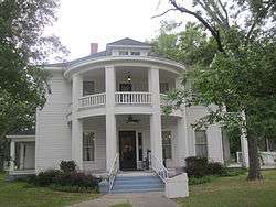
The historic Hawthorn-Clabaugh-Patterson House is now the location of the Carthage Chamber of Commerce. | |
| Motto: "Country at its best!" | |
 Location of Carthage, Texas | |
 | |
| Coordinates: 32°9′23″N 94°20′32″W / 32.15639°N 94.34222°WCoordinates: 32°9′23″N 94°20′32″W / 32.15639°N 94.34222°W | |
| Country |
|
| State |
|
| County | Panola |
| Area | |
| • Total | 10.5 sq mi (27.3 km2) |
| • Land | 10.5 sq mi (27.2 km2) |
| • Water | 0.0 sq mi (0.1 km2) |
| Elevation | 312 ft (95 m) |
| Population (2010) | |
| • Total | 6,779 |
| • Density | 645.6/sq mi (249.2/km2) |
| Time zone | Central (CST) (UTC-6) |
| • Summer (DST) | CDT (UTC-5) |
| ZIP code | 75633 |
| Area code(s) | 903 |
| FIPS code | 48-13108[1] |
| GNIS feature ID | 1353900[2] |


Carthage is a city in Panola County, Texas, United States. This city is one hundred and fifty miles southeast of Dallas. The population was 6,779 at the 2010 census. It is the county seat of Panola County,[3] and is situated in East Texas near the Louisiana state line.
Geography
According to the United States Census Bureau, Carthage has a total area of 10.5 square miles (27 km2), of which 10.5 square miles (27 km2) is land and 0.04 square miles (0.10 km2) (0.4%) is water.
Demographics
| Historical population | |||
|---|---|---|---|
| Census | Pop. | %± | |
| 1880 | 290 | — | |
| 1890 | 554 | 91.0% | |
| 1920 | 1,366 | — | |
| 1930 | 1,651 | 20.9% | |
| 1940 | 2,178 | 31.9% | |
| 1950 | 4,750 | 118.1% | |
| 1960 | 5,262 | 10.8% | |
| 1970 | 5,392 | 2.5% | |
| 1980 | 6,447 | 19.6% | |
| 1990 | 6,496 | 0.8% | |
| 2000 | 6,664 | 2.6% | |
| 2010 | 6,779 | 1.7% | |
| Est. 2015 | 6,844 | [4] | 1.0% |
As of the census[1] of 2010, there were 6,779 people, 2,628 households, and 1,745 families residing in the city. The population density was 645.6 people per square mile (249.2/km²). There were 2,909 housing units at an average density of 277.0 per square mile (106.9/km²). The racial makeup of the city was 69.5% White, 21.1% African American, 0.5% Native American, 0.7% Asian, 6.5% from other races, and 1.7% from two or more races. Hispanic or Latino of any race were 11.0% of the population.
There were 2,628 households out of which 29.8% had children under the age of 18 living with them, 45.6% were married couples living together, 16.4% had a female householder with no husband present, and 33.6% were non-families. 30.5% of all households were made up of individuals and 14.8% had someone living alone who was 65 years of age or older. The average household size was 2.45 and the average family size was 3.04.
In the city the population was spread out with 24.6% under the age of 18, 11.2% from 18 to 24, 23.9% from 25 to 44, 24.1% from 45 to 64, and 16.3% who were 65 years of age or older. The median age was 35.9 years. For every 100 females there were 88.3 males. For every 100 females age 18 and over, there were 83.8 males.
As of the 2000 Census, the median income for a household in the city was $31,822, and the median income for a family was $37,031. Males had a median income of $33,080 versus $21,473 for females. The per capita income for the city was $16,332. About 11.8% of families and 13.2% of the population were below the poverty line, including 15.2% of those under age 18 and 12.9% of those age 65 or over.
The film Bernie is a fictionalized account of a celebrated murder in Carthage.[6]
Education
The City of Carthage is served by the Carthage Independent School District.
There is also the two-year Panola College, a community college located across from Carthage City Hall.
The Carthage Bulldogs football team won their fourth state title in six years in 2013 against Kilgore at AT&T Stadium.
Points of interest
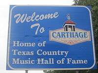
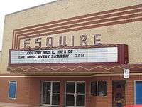
The Texas Country Music Hall of Fame is located in Carthage, which also houses the Tex Ritter museum. The Jim Reeves Memorial is located just on the outskirts of Carthage, east on U.S. 79. Reeves and Ritter were from the nearby unincorporated communities of Galloway and Murvaul, respectively.
The old Panola County Jail Museum is located on North Shelby Street.
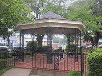
Panola County Heritage Museum is located at 100 East Sabine Street across from the gazebo in downtown Anderson Park.
Lake Murvaul is fifteen miles west of Carthage on Murvaul Bayou.
Notable people
- Derek Wayne Johnson, award winning film director, writer, producer, and actor
- Philip Humber, MLB pitcher for five teams; pitched a perfect game for Chicago White Sox against the Seattle Mariners on April 21, 2012
- Margie Neal, newspaper publisher and first woman elected to the Texas State Senate;[7] a Texas Historical Marker in the center of town recognizes her achievements.[8]
- Bill O'Neal, historian of the American West, country music, and baseball
- Perfect Stranger, a 1990s country band
- Jim Reeves, singer
- Tex Ritter, singer
- Brandon Rhyder, singer
- Mildred Fay Jefferson, first African-American woman to graduate from Harvard Medical School, founding member and former President of the National Right to Life Committee
- Bernie Tiede, murderer and subject of the 2011 film Bernie
- Jack Boynton Strong, Texas legislator and businessman
Media
Carthage is served by two local radio stations: KGAS 1590 AM and KGAS 104.3 FM and by a local newspaper, The Panola Watchman. The nearest media market of notable size is in nearby Shreveport, Louisiana.
Climate
The climate in this area is characterized by hot, humid summers and generally mild to cool winters. According to the Köppen Climate Classification system, Carthage has a humid subtropical climate, abbreviated "Cfa" on climate maps.[9]
References
- 1 2 "American FactFinder". United States Census Bureau. Archived from the original on 2013-09-11. Retrieved 2008-01-31.
- ↑ "US Board on Geographic Names". United States Geological Survey. 2007-10-25. Retrieved 2008-01-31.
- ↑ "Find a County". National Association of Counties. Archived from the original on 2011-05-31. Retrieved 2011-06-07.
- ↑ "Annual Estimates of the Resident Population for Incorporated Places: April 1, 2010 to July 1, 2015". Retrieved July 2, 2016.
- ↑ "Census of Population and Housing". Census.gov. Archived from the original on April 22, 2013. Retrieved June 4, 2015.
- ↑ Rhodes, Joe (2012-04-12). "Article in New York Times magazine". The New York Times. Retrieved 17 April 2012.
- ↑ "NEAL, MARGIE ELIZABETH". tshaonline.org. Retrieved 14 September 2015.
- ↑ "Texas Historical Marker – Margie Neal". 9key.com. Retrieved 14 September 2015.
- ↑ Climate Summary for Carthage, Texas
External links
Municipalities and communities of Panola County, Texas, United States | ||
|---|---|---|
| Cities |  | |
| Town | ||
| Unincorporated communities | ||
| Ghost town | ||
| Footnotes | ‡This populated place also has portions in an adjacent county or counties | |

City of Shreveport & Shreveport/Bossier City Metro | ||
|---|---|---|
| Topics | ||
| Shreveport Neighborhoods |
| |
| The Ark-La-Tex | ||