Clarendon, Texas
| Clarendon, Texas | |
|---|---|
| City | |
|
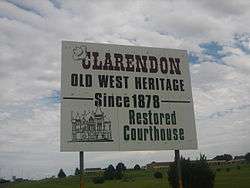
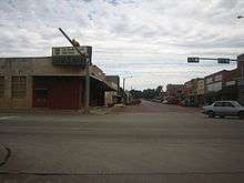
Clarendon welcome sign on U.S. Highway 287 | |
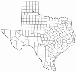 Location of Clarendon, Texas | |
 | |
| Coordinates: 34°56′11″N 100°53′28″W / 34.93639°N 100.89111°WCoordinates: 34°56′11″N 100°53′28″W / 34.93639°N 100.89111°W | |
| Country | United States |
| State | Texas |
| County | Donley |
| Area | |
| • Total | 3.0 sq mi (7.8 km2) |
| • Land | 2.9 sq mi (7.5 km2) |
| • Water | 0.1 sq mi (0.3 km2) |
| Elevation | 2,733 ft (833 m) |
| Population (2010) | |
| • Total | 2,026 |
| • Density | 698/sq mi (269.5/km2) |
| Time zone | Central (CST) (UTC-6) |
| • Summer (DST) | CDT (UTC-5) |
| ZIP code | 79226 |
| Area code(s) | 806 |
| FIPS code | 48-15112[1] |
| GNIS feature ID | 1354555[2] |

Clarendon is a city in Donley County, Texas, United States. The population was 2,026 at the 2010 census.[3] The county seat of Donley County,[4] Clarendon is located on U.S. Highway 287 in the Texas Panhandle, 60 miles (97 km) east of Amarillo.
History
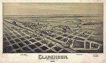
Before the rise of Amarillo, Clarendon, along with Mobeetie in Wheeler County, and Tascosa in Oldham County, was one of the three original Panhandle settlements. Established in 1878, Clarendon moved after it was bypassed by the Fort Worth and Denver Railroad.[5]
The town founder was a Methodist clergyman, L.H. Carhart, who envisioned a "sobriety settlement" in contrast to typical boomtowns of that era. Clarendon acquired the sobriquet "Saints Roost" from local cowboys; hence the unusual name of the Clarendon museum, the Saints' Roost Museum.[6]
The Sandell Drive-In, built by Gary Barnhill (born 1920) and named after his daughters, Sandra and Adele, opened on Texas State Highway 70 in 1955 and closed in 1984. In 2001, John Earl Morrow (born around 1954), a Clarendon resident and owner of Morrow Drilling and Service, purchased the property from the Barnhills and in August 2002 reopened the drive-in. The facility, which can handle 300 cars, is operated by Morrow and volunteers during the summers. Morrow was motivated to bring back the facility because he had viewed films there during his childhood.[7]
Geography
Clarendon is located southwest of the center of Donley County at 34°56′11″N 100°53′28″W / 34.93639°N 100.89111°W (34.936415, −100.891182).[8] U.S. Highway 287 passes through the city, leading west 60 miles (97 km) to Amarillo and southeast 57 miles (92 km) to Childress. Texas State Highway 70 leads north 17 miles (27 km) to Interstate 40 and south 42 miles (68 km) to Turkey.
According to the United States Census Bureau, the city has a total area of 3.0 square miles (7.8 km2), of which 2.9 square miles (7.5 km2) is land and 0.1 square miles (0.3 km2), or 3.49%, is covered by water.[3]
Climate
| Climate data for Clarendon, Texas (1981–2010) | |||||||||||||
|---|---|---|---|---|---|---|---|---|---|---|---|---|---|
| Month | Jan | Feb | Mar | Apr | May | Jun | Jul | Aug | Sep | Oct | Nov | Dec | Year |
| Average high °F (°C) | 52.8 (11.6) |
56.3 (13.5) |
64.5 (18.1) |
73.3 (22.9) |
81.4 (27.4) |
89.1 (31.7) |
94.3 (34.6) |
93.0 (33.9) |
85.2 (29.6) |
74.6 (23.7) |
62.9 (17.2) |
52.6 (11.4) |
73.3 (22.9) |
| Average low °F (°C) | 23.8 (−4.6) |
27.2 (−2.7) |
34.4 (1.3) |
42.9 (6.1) |
53.3 (11.8) |
62.2 (16.8) |
66.2 (19) |
65.0 (18.3) |
56.9 (13.8) |
44.9 (7.2) |
33.4 (0.8) |
24.6 (−4.1) |
44.6 (7) |
| Average precipitation inches (mm) | 0.70 (17.8) |
0.80 (20.3) |
1.48 (37.6) |
2.26 (57.4) |
3.23 (82) |
3.55 (90.2) |
2.13 (54.1) |
3.02 (76.7) |
2.54 (64.5) |
2.20 (55.9) |
1.04 (26.4) |
0.95 (24.1) |
23.96 (608.6) |
| Average snowfall inches (cm) | 1.8 (4.6) |
0.7 (1.8) |
0.8 (2) |
0.3 (0.8) |
0.0 (0) |
0.0 (0) |
0.0 (0) |
0.0 (0) |
0.0 (0) |
0.0 (0) |
0.4 (1) |
2.2 (5.6) |
6.2 (15.7) |
| Source: NOAA[9] | |||||||||||||
Demographics
| Historical population | |||
|---|---|---|---|
| Census | Pop. | %± | |
| 1890 | 949 | — | |
| 1910 | 1,946 | — | |
| 1920 | 2,456 | 26.2% | |
| 1930 | 2,756 | 12.2% | |
| 1940 | 2,431 | −11.8% | |
| 1950 | 2,577 | 6.0% | |
| 1960 | 2,172 | −15.7% | |
| 1970 | 1,974 | −9.1% | |
| 1980 | 2,220 | 12.5% | |
| 1990 | 2,067 | −6.9% | |
| 2000 | 1,974 | −4.5% | |
| 2010 | 2,026 | 2.6% | |
| Est. 2015 | 1,944 | [10] | −4.0% |
As of the census[1] of 2000, 1,974 people, 768 households, and 489 families resided in the city. The population density was 679.0 people per square mile (261.9/km²). The 929 housing units averaged of 319.5 per square mile (123.3/km²). The racial makeup of the city was 87.49% White, 7.19% African American, 0.76% Native American, 0.15% Asian, 2.99% from other races, and 1.42% from two or more races. Hispanics or Latinos of any race were 6.23% of the population.
Of the 768 households, 28.1% had children under the age of 18 living with them, 50.4% were married couples living together, 10.3% had a female householder with no husband present, and 36.3% were not families. About 34.9% of all households were made up of individuals, and 20.2% had someone living alone who was 65 years of age or older. The average household size was 2.31 and the average family size was 2.97.
In the city, the population was distributed as 23.5% under the age of 18, 13.9% from 18 to 24, 21.7% from 25 to 44, 21.0% from 45 to 64, and 19.9% who were 65 years of age or older. The median age was 38 years. For every 100 females, there were 89.4 males. For every 100 females age 18 and over, there were 87.3 males.
The median income for a household in the city was $27,824, and for a family was $37,083. Males had a median income of $25,486 versus $18,882 for females. The per capita income for the city was $15,436. About 11.2% of families and 15.4% of the population were below the poverty line, including 19.0% of those under age 18 and 19.9% of those age 65 or over.
Education
Clarendon is served by the Clarendon Consolidated Independent School District. The school colors are maroon, white, and black.[12]
Clarendon is home to Clarendon College (established 1898), the oldest center of higher education in the Texas Panhandle. It was originally affiliated with the Methodist Church. The college is located off Highway 287 in north Clarendon. The mascot is the bulldog. The colors are green and white.[13]
The Saints' Roost Museum houses artifacts of the early years of Clarendon and features exhibits on Goodnight, Bugbee, the Red River War, and the Fort Worth and Denver Railway depot.
The local newspaper is the Clarendon Enterprise.
Notable people
Clarendon has been the home of numerous notable persons.
- Aviation historian Randy Acord (1919–2008), a Clarendon native, founded the Alaska Air Pioneer Museum in Fairbanks, where he had been stationed as a test pilot in 1943. Acord won the Alaska-Siberia Lend Lease Award for his contributions to Russian-North American relations during World War II.
- JA Ranch matriarch Cornelia Wadsworth Ritchie Adair maintained a house in Clarendon and was a benefactor of many Donley County charities. The Saints' Roost Museum in Clarendon is the restoration of her former Adair Hospital. She was active, too, in the Episcopal Church in Clarendon. She also maintained residences in England, having become a naturalized British subject, and in Ireland, where she lived part of the year at her late husband's Glenveagh Castle. She is buried in Ireland.
- Ed Boykin, New Mexico state legislator and educator, was born in Clarendon.
- Harold Dow Bugbee, artist of ranching on the Texas South Plains and the Panhandle, maintained his family near Clarendon. He was also the art curator of the Panhandle-Plains Museum for many years prior to his death in 1963. Bugbee's second wife, Olive Vandruff Bugbee, an artist in her own right, lived at the Harold Dow Bugbee Ranch from the time of her brief marriage to Bugbee in 1961 until her death in 2003. The couple left the ranch estate to the Panhandle Plains Museum.
- The historian Harley True Burton, a former president of Clarendon College, served as the town mayor from 1955–1963. Burton wrote The History of the JA Ranch, co-owned by John George Adair of Ireland and Charles Goodnight, who spent his later years in Clarendon.
- Renowned buffalo hunter Frank Collinson (1855–1943) lived primarily in Childress, but is buried in Clarendon.
- Clarendon is the hometown of former Oklahoma Sooners standout running back Kenny King. He also played for the Oakland Raiders. King set a Super Bowl record for the longest touchdown reception with an 80-yarder in the Raiders' 27-10 Super Bowl XV victory over the Philadelphia Eagles. That record stood until January 26, 1997.
- Clarence Hailey Long, the inspiration for the original Marlboro Man tobacco advertising campaign, lived his later years in Clarendon. A former employee of the JA Ranch, he joined the First Baptist Church in Clarendon in 1953, after the death of his father in a bronco accident.[14]
- William S. Lott (1918–2009) was a district judge in Williamson County for 16 years. He was born in Clarendon, and lived there until graduating from high school. He worked at first as a lawyer, then a judge, in a legal career that spanned 70 years. The William S. Lott Juvenile Center in Georgetown, Texas, is named after him.
- Odell McBrayer (1930–2008), a Fort Worth attorney, grew up in Clarendon. He was an unsuccessful Republican candidate for governor in 1974, having lost his primary to Jim Granberry, former mayor of Lubbock. McBrayer was affiliated with the Full Gospel Business Men's Fellowship International.[15]
- Blues musician William Daniel McFalls, better known as Blues Boy Willie, lived in Clarendon during the middle 1960s, when he studied guitar and upright bass at Clarendon College.
- Montgomery Harrison Wadsworth Ritchie (1910–1999), grandson of Cornelia Adair, managed the JA from 1935 until his retirement in 1993 and hence maintained a Clarendon address.
- Republican U.S. Representative William Mac Thornberry, who represents the Texas Panhandle in a district which stretches from Amarillo east to Wichita Falls, was born in Clarendon in 1958.
References
- 1 2 "American FactFinder". United States Census Bureau. Archived from the original on September 11, 2013. Retrieved 2008-01-31.
- ↑ "US Board on Geographic Names". United States Geological Survey. October 25, 2007. Retrieved 2008-01-31.
- 1 2 "Geographic Identifiers: 2010 Demographic Profile Data (G001): Clarendon city, Texas". American Factfinder. U.S. Census Bureau. Retrieved January 8, 2016.
- ↑ "Find a County". National Association of Counties. Archived from the original on May 31, 2011. Retrieved 2011-06-07.
- ↑ Lester Fields Sheffy, The Life and Times of Timothy Dwight Hobart, 1855-1935: Colonization of West Texas (Canyon, Texas: Panhandle-Plains Historical Society, 1950), p. 156
- ↑ Texas Online: Clarendon, Texas
- ↑ "Sandell Drive-In". cinematreasures.org. Retrieved August 19, 2010.
- ↑ "US Gazetteer files: 2010, 2000, and 1990". United States Census Bureau. February 12, 2011. Retrieved 2011-04-23.
- ↑ "NOWData – NOAA Online Weather Data". National Oceanic and Atmospheric Administration. Retrieved May 5, 2013.
- ↑ "Annual Estimates of the Resident Population for Incorporated Places: April 1, 2010 to July 1, 2015". Retrieved July 2, 2016.
- ↑ "Census of Population and Housing". Census.gov. Archived from the original on May 11, 2015. Retrieved June 4, 2015.
- ↑ Website. www.clarendon.k12.tx.us
- ↑ http://www.clarendoncollege.edu
- ↑ C. H. Long, Jr., exhibit, Panhandle-Plains Historical Museum at Canyon
- ↑ Tulsa World: Deaths
External links
| Wikimedia Commons has media related to Clarendon, Texas. |
Municipalities and communities of Donley County, Texas, United States | ||
|---|---|---|
| Cities |  | |
| Unincorporated communities | ||
