Snyder, Texas
| Snyder, Texas | |
|---|---|
| City | |
 | |
 Location of Snyder, Texas | |
| Coordinates: 32°42′56″N 100°54′52″W / 32.71556°N 100.91444°WCoordinates: 32°42′56″N 100°54′52″W / 32.71556°N 100.91444°W | |
| Country | United States |
| State | Texas |
| County | Scurry |
| Area | |
| • Total | 8.6 sq mi (22.3 km2) |
| • Land | 8.6 sq mi (22.2 km2) |
| • Water | 0.0 sq mi (0.1 km2) |
| Elevation | 2,320 ft (707 m) |
| Population (2000) | |
| • Total | 10,783 |
| • Density | 1,256.8/sq mi (485.2/km2) |
| Time zone | Central (CST) (UTC-6) |
| • Summer (DST) | CDT (UTC-5) |
| ZIP codes | 79549-79550 |
| Area code(s) | 325 |
| FIPS code | 48-68624[1] |
| GNIS feature ID | 1347340[2] |
| Website | http://ci.snyder.tx.us/ |
Snyder is a town in, and the county seat of Scurry County, Texas, United States.[3] The population was 10,653 at the 2010 census. The city is located in the lower part of the Southwestern Tablelands ecological region.
History
Snyder is named for merchant and buffalo hunter William Henry (Pete) Snyder, who built a trading post on Deep Creek in 1878. It soon drew fellow hunters and a small settlement grew up around the post. The nature of those early dwellings, mostly constructed of buffalo hide and tree branches, led to the communities first, if unofficial, name of "Hide Town". Another early name, "Robber's Roost" is said to owe its beginnings to the sometimes nefarious nature of a few residents and a lack of law enforcement.[4] A statue of an albino buffalo on the grounds of the Scurry County courthouse in Snyder pays homage to the town's beginnings as a buffalo trading post.
Snyder predates Scurry County itself by two years, with a town plan being drawn up in 1882 while the county wasn't organized until 1884. A population of 600 was reported in 1892, with a school, two churches, a grist mill, steam gin, two banks and two weekly newspapers being part of the community. Significant change happened in 1907 when Snyder was granted a city charter, and construction began on the Roscoe, Snyder and Pacific Railway. The 1910 census indicated Snyder had grown to a population of 2,514. The Atchison, Topeka & Santa Fe Railway tracks reached Snyder in 1911, spurring further growth. Ranching and farming were the primary economic backbone of Snyder through the first half of the 20th century.
This changed in 1948 when oil was discovered in the Canyon Reef area north of town. Snyder became a boomtown as the population jumped to approximately 12,000 in just a year's time. By the time the boom ended in 1951 an estimated peak popularion of 16,000 had been reached. This soon decreased to the 10,000 to 11,000 level and stabilized. Although the boom was over, oil still remained a vital part of the local economy, with the Snyder area being one of the leading oil producing areas in Texas. In 1973 the one billionth barrel of oil was pumped from the nearby oil field.
An industrial base was established in the 1960s and early 1970s, diversifying the town's economy and making it less susceptible to cycles of boom and bust. Higher education came to Snyder in 1971 with the founding of Western Texas College. One of the most successful Texas Colleges for graduation and job placement, Western Texas offers Associate of Arts degree programs as well as vocational program certifications. Enrollment in 2009 was over 2,500 students.
The Scurry County Coliseum in Snyder, operated by Western Texas College since 2008, is a large arena which hosts area events. Outside the Coliseum is a locomotive engine and a small restored historic village. Also located in Snyder is the Diamond M Museum. Established by local oilman and rancher Clarence T. McLaughlin, the museum houses over eighty bronze works and two hundred paintings. Among the collection are works by Peter Hurd and Andrew Wyeth.
Geography and climate
Snyder is located on Deep Creek, a minor tributary of the Colorado River of Texas.
Snyder is approximately 90 miles (140 km) southeast of Lubbock, 80 miles (130 km) northwest of Abilene, 90 miles (140 km) northeast of Midland, and 100 miles (160 km) north of San Angelo.
On September 11, 2011, a magnitude 4.4 earthquake centered 20 km (12 miles) north-northeast of Snyder produced light-to-moderate shaking, according to the U.S. Geological Survey's National Earthquake Information Center.
| Climate data for Snyder, Texas (1981–2010) | |||||||||||||
|---|---|---|---|---|---|---|---|---|---|---|---|---|---|
| Month | Jan | Feb | Mar | Apr | May | Jun | Jul | Aug | Sep | Oct | Nov | Dec | Year |
| Average high °F (°C) | 55.7 (13.2) |
59.8 (15.4) |
68.0 (20) |
77.1 (25.1) |
85.2 (29.6) |
90.8 (32.7) |
94.1 (34.5) |
93.1 (33.9) |
86.3 (30.2) |
76.8 (24.9) |
66.0 (18.9) |
56.1 (13.4) |
75.7 (24.3) |
| Average low °F (°C) | 28.3 (−2.1) |
31.9 (−0.1) |
39.2 (4) |
47.4 (8.6) |
58.3 (14.6) |
66.3 (19.1) |
69.6 (20.9) |
68.7 (20.4) |
61.3 (16.3) |
50.5 (10.3) |
38.2 (3.4) |
28.8 (−1.8) |
49.0 (9.4) |
| Average precipitation inches (mm) | 0.82 (20.8) |
1.20 (30.5) |
1.59 (40.4) |
1.70 (43.2) |
2.87 (72.9) |
3.49 (88.6) |
1.98 (50.3) |
2.18 (55.4) |
2.17 (55.1) |
2.27 (57.7) |
1.14 (29) |
0.97 (24.6) |
22.39 (568.7) |
| Average snowfall inches (cm) | 0.0 (0) |
0.4 (1) |
0.0 (0) |
0.0 (0) |
0.0 (0) |
0.0 (0) |
0.0 (0) |
0.0 (0) |
0.0 (0) |
0.0 (0) |
0.5 (1.3) |
0.7 (1.8) |
1.6 (4.1) |
| Source: NOAA[5] | |||||||||||||
Demographics
| Historical population | |||
|---|---|---|---|
| Census | Pop. | %± | |
| 1890 | 500 | — | |
| 1910 | 2,514 | — | |
| 1920 | 2,179 | −13.3% | |
| 1930 | 3,008 | 38.0% | |
| 1940 | 3,815 | 26.8% | |
| 1950 | 12,010 | 214.8% | |
| 1960 | 13,850 | 15.3% | |
| 1970 | 11,171 | −19.3% | |
| 1980 | 12,705 | 13.7% | |
| 1990 | 12,195 | −4.0% | |
| 2000 | 10,783 | −11.6% | |
| 2010 | 11,202 | 3.9% | |
| Est. 2015 | 11,768 | [6] | 5.1% |
| U.S. Decennial Census | |||
As of the census[1] of 2010, there were 11,202 people, 4,128 households, and 2,880 families residing in the city. The population density was 1,256.8 people per square mile (485.2/km²). There were 5,013 housing units at an average density of 584.3 per square mile (225.6/km²). The racial makeup of the city was 79.00% White, 4.69% African American, 0.57% Native American, 0.25% Asian, 13.68% from other races, and 1.81% from two or more races. Hispanic or Latino of any race were 31.8% of the population.
There were 4,068 households out of which 34.9% had children under the age of 18 living with them, 55.3% were married couples living together, 11.8% had a female householder with no husband present, and 29.2% were non-families. 26.5% of all households were made up of individuals and 14.2% had someone living alone who was 64 years of age or older. The average household size was 2.56 and the average family size was 3.10.
In the city the population was spread out with 27.8% under the age of 18, 10.5% from 18 to 24, 24.0% from 25 to 44, 20.8% from 45 to 64, and 16.9% who were 65 years of age or older. The median age was 36 years. For every 100 females there were 87.3 males. For every 100 females age 18 and over, there were 83.9 males.
The median income for a household in the city was $42,077, and the median income for a family was $55,567. Males had a median income of $30 033 versus $17 609 for females. The per capita income for the city was $23,296. About 13.7% of families and 17.0% of the population were below the poverty line, including 22.4% of those under age 18 and 10.8% of those age 65 or over.
Government
The Texas Department of Criminal Justice operates the Snyder Distribution Center[7] in Snyder and the Price Daniel Unit[8] located 4 miles outside of Snyder.
The United States Postal Service operates the Snyder Post Office.[9]
Economy
Snyder enjoys a strong economy, driven by the oil, gas, and wind industries. In 2012, 994 jobs were created in Snyder, leading to 20% job growth in the community, according to the Development Corporation of Snyder.[10] The Scurry Area Canyon Reef Operators (SACROC) oilfield is among the largest and most productive in the nation. Two of the largest wind farms in the nation are located in Snyder area. There are plans to build two larger wind farms in 2013. Other important industries in Snyder include manufacturing and cotton.
Oil
In addition to the SACROC field, Snyder is also located within the footprint of the newly discovered Cline Shale.[11] Devon Energy estimates the Cline Shale to produce 30 billion barrels of oil, surpassing the Bakken Shale in North Dakota and the Eagle Ford Shale in South Texas.[12] The thickness of the Cline Shale is equivalent to roughly ten Eagle Ford shales stacked on top of each other.[11] As exploration and development of this new shale continues in the Snyder area, the city is expected to see a large population increase with new restaurants, apartments, and retail shopping.
Wind Energy
A section of the second largest wind farm in the United States, the Roscoe Wind Farm, is already located in the Snyder area.[13][14] In late 2013 and 2014, Tri-Global Energy will begin construction on two new wind farms near Snyder. Combined, the Fluvanna Renewable Energy Project and the Canyon Wind project will add 700 MW wind capacity and represent a $1.4 billion investment in the Snyder and surrounding areas.[15][16]
Industrial and Rail Park
There are two industrial parks in Snyder, including one that has rail access. Current occupants in these two industrial parks include W.L Plastics, Tractor Supply, Mitsubishi Power Systems, Big Country Electric, Kyle Erwin Construction, Four Star Hose & Supply, and Total Truck & Trailer. With the impending Cline Shale oil boom, more companies are looking to Snyder for their expansion plans.[17]
Education
The Snyder Independent School District serves Snyder. The schools are Snyder Primary, Snyder Intermediate, Snyder Junior High School, Snyder Academy, and Snyder High School.
Western Texas College, a two-year West Texas Community College, is located in Snyder. In addition to traditional academic courses, Western Texas College offers several career/technical programs, including Communication Design, Early Childhood Education, Electrical Distribution Systems, Information Technology Business Management, Petroleum Technology, Radio Broadcasting, Solar Energy Technology, Turfgrass and Landscape Management,Vocational Nursing, and Welding.
Students graduating from Scurry County high schools can take advantage of the Opportunity Tuition Waiver. Qualified students can enroll in college courses tuition-free.
Popular culture
Snyder plays a key plot role, and is frequently mentioned, in the Southern Victory alternate history novel series in its final phase Settling Accounts by Harry Turtledove, where a camp a few miles out of Snyder becomes the timeline's equivalent of Auschwitz under a fascistic Confederate government.
At the turn of the 20th century, Snyder was rocked by a deadly feud between the families of Billy Johnson and Ed Sims. Gladys Johnson, daughter of banker Billy Johnson, at the age of fourteen in 1914, married Ed Sims. The young couple had two daughters but soon divorced in July 1916. Sims was thereafter shot dead by a Johnson family member. The grand jury in Lamesa failed to bring a true bill against the killer. Gladys Johnson Sims in the spring of 1917 married Texas Ranger Frank Hamer, who had lost two children from a previous marriage. The Hamers raised four children, the daughters of Gladys and Ed Sims, and two of their own, including Frank Hamer, Jr. Frank Hamer died in 1955, but Gladys lived in their home in Austin until her death in 1986 at the age of eighty-five.[18]
Notable people
- Kevin Alejandro (born 1976), actor who starred in Ugly Betty on ABC as Santos and Southland on TNT as Detective Nate Moretta; recurring cast member of HBO series True Blood and stars in CBS series Golden Boy; grew up in Snyder.
- Powers Boothe (born 1948), Emmy-Award winning actor, portrayed the demonic clergyman Jim Jones in Guyana Tragedy: The Story of Jim Jones, Curly Bill in Tombstone and Senator Roark in Sin City; native of Snyder.
- Charlene Holt, actress and model, starred in western film El Dorado (1966 film) as Maudie, the love interest of Robert Mitchum and John Wayne; born in Snyder.
- Dick Jones (1927-2014), actor, starred in Buffalo Bill, Jr. in syndication in 1955; as "Dickie" Jones, he was voice of title character in 1940 Disney film Pinocchio; native of Snyder.
- Charley Lockhart, treasurer of Texas from 1931 to 1941, received media attention nationwide for being a dwarf and was known as "the smallest elected official in the biggest state."
- Dave McGinnis, football coach, head coach of NFL's Arizona Cardinals from 2000–03; graduated in 1969 from Snyder High School.
- Barry Tubb, actor, portrayed Wolfman in Top Gun, Jasper in Lonesome Dove, directed the small film Grand Champion; born in Snyder.
- Brad Maule, (born October 11, 1951), actor, best known for his longtime role as Dr. Tony Jones on the television daytime drama General Hospital, which he played until February 2006; was born in Rotan, Texas but graduated from Snyder High School, was a student of Jerry P. Worsham, who was theatre arts educator for several of Snyder's notable actors and actresses.
- Devyn DeLoera, A member of Christina Aguilera's team during season 3 of The Voice is from Snyder.
Gallery
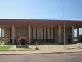 The Scurry County Coliseum in Snyder, operated since 2008 by Western Texas College.
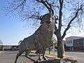 Albino buffalo statue at the Scurry County Courthouse in Snyder.
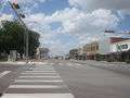 Downtown Snyder just north of the courthouse.
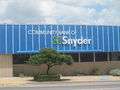 Community Bank of Snyder.
 Cogdell Memorial Hospital is located near Western Texas College in Snyder.
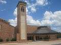 First Baptist Church in downtown Snyder.
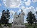 Jesus and the Woman at the Well sculpture at Hillside Memorial Gardens Cemetery south of Snyder.
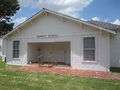 Former Dermott School, relocated to the Coliseum grounds in Snyder.
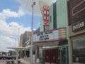 Ritz Theater in downtown Snyder.
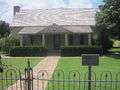 This 19th-century pioneer house, constructed by physician and Confederate veteran, J.C. Cornelius. The restored home now serves as a museum.
See also
References
- 1 2 "American FactFinder". United States Census Bureau. Retrieved 2008-01-31.
- ↑ "US Board on Geographic Names". United States Geological Survey. 2007-10-25. Retrieved 2008-01-31.
- ↑ "Find a County". National Association of Counties. Retrieved 2011-06-07.
- ↑ Wiggins, Noel. "Snyder, Texas. Handbook of Texas Online". Texas State Historical Association. Retrieved 14 June 2012.
- ↑ "NOWData - NOAA Online Weather Data". National Oceanic and Atmospheric Administration. Retrieved May 6, 2013.
- ↑ "Annual Estimates of the Resident Population for Incorporated Places: April 1, 2010 to July 1, 2015". Retrieved July 2, 2016.
- ↑ "Snyder Distribution Center." Texas Department of Criminal Justice. Retrieved on May 22, 2010.
- ↑ Daniel (DL). Texas Department of Criminal Justice. Retrieved on November 28, 2012.
- ↑ "Post Office Location - SNYDER." United States Postal Service. Retrieved on May 22, 2010.
- ↑ "$1 Billion Reasons to Look at Snyder, TX" (PDF). Development Corporation of Snyder. Retrieved 5 June 2013.
- 1 2 Eady, Ashley. "Exploration continues to fuel expectations for Cline Shale oil boom". Lubbock Avalanche-Journal. Retrieved 5 June 2013.
- ↑ Hillier, Jennifer. "West Texas shale could dwarf Eagle Ford". FuelFix.
- ↑ American Wind Energy Association. "AWEA U.S. Wind Industry Annual Market Report".
- ↑ O'Grady, Eileen (1 October 2013). "E.ON completes world's largest wind farm in Texas". Reuters. Retrieved 5 June 2013.
- ↑ "Fluvanna Renewable Energy Project". Tri-Global Energy. Retrieved 5 June 2013.
- ↑ "Canyon Wind". Tri-Global Energy. Retrieved June 5, 2013.
- ↑ "DCOS". Development Corporation of Snyder. Retrieved 5 June 2013.
- ↑ Bill O'Neal, "Romeo and Juliet--West Texas Style: The Johnson-Sims Feud," West Texas Historical Association annual meeting, April 1, 2011, Lubbock, Texas
External links
| Wikimedia Commons has media related to Snyder, Texas. |
- City of Snyder
- Development Corporation of Snyder
- Snyder Chamber of Commerce
- Western Texas College
- Snyder Independent School District
Municipalities and communities of Scurry County, Texas, United States | ||
|---|---|---|
| City | 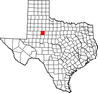 | |
| CDP | ||
| Unincorporated communities | ||
