Georgetown, Texas
| Georgetown, Texas | |
|---|---|
| City | |
| Nickname(s): Red Poppy Capital of Texas, Retirement Capital of Texas, Gtown | |
| Motto: "Sincerely Yours" | |
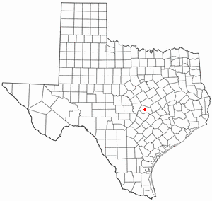 Location of Georgetown, Texas | |
 | |
| Coordinates: 30°39′4″N 97°40′53″W / 30.65111°N 97.68139°WCoordinates: 30°39′4″N 97°40′53″W / 30.65111°N 97.68139°W | |
| Country | United States |
| State | Texas |
| County | Williamson |
| Settled | 1840s |
| Incorporated | 1848 |
| Government | |
| • Type | Council-Manager |
| • Mayor | Dale Ross |
| • City Manager | David Morgan |
| Area | |
| • Land | 47.86 sq mi (124.0 km2) |
| • Water | 2.1 sq mi (5 km2) |
| Elevation | 755 ft (230 m) |
| Population (2014) | |
| • Total | 55,716 |
| Time zone | Central (CST) (UTC-6) |
| • Summer (DST) | CDT (UTC-5) |
| ZIP codes | 78626, 78627, 78628, 78633 |
| Area code(s) | 512 & 737 |
| FIPS code | 48-29336 [1] |
| GNIS feature ID | 1357960 [2] |
| Website | Georgetown.org |
Georgetown is a city in and the county seat of Williamson County, Texas, United States,[3] with a population of 63,716 at the 2016 Census Estimate. It is 30 miles from Austin. Southwestern University, the oldest university in Texas, was founded in 1840 and is located in Georgetown about one-half mile from the historic square. Sun City Texas is a large retirement-oriented and age-restricted development that constitutes more than one-third of Georgetown's population.
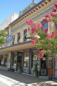
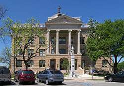
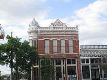
Georgetown has a notable range of Victorian commercial and residential architecture. In 1976, a local historic ordinance was passed to recognize and protect the significance of the historic central business district, and in 1977, the Williamson County Courthouse Historical District, containing some 46 contributing structures, was listed on the National Register of Historic Places.[4] Georgetown is also known as the "Red Poppy" Capital of Texas for the red poppy (Papaver rhoeas) wildflowers planted throughout the city. Georgetown's Red Poppy Festival, which attracts up to 30,000 visitors annually, is held in April each year on the historic square.
History
Prehistoric era
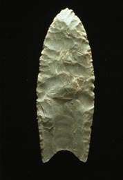
Georgetown has been the site of human habitation since at least 9,000 B.C., and possibly considerably before that. The earliest known inhabitants of the county, during the late Pleistocene (Ice Age), can be linked to the Clovis culture, a Paleo-Indian culture characterized by the manufacture of distinctive "Clovis points." that first appeared around 9200 B.C., and possibly as early as 11,500 B.C.,[5] at the end of the last glacial period. One of the most important discoveries in recent times is that of the ancient skeletal remains dubbed "The Leanderthal Lady" because of its age and proximity to nearby community Leander, Texas.[6] The site is immediately southwest of Georgetown and was discovered by accident by Texas Department of Transportation workers while core samples for a new highway were being drilled. The site has been extensively studied for many years, and samples carbon date the findings to the Pleistocene period, approximately 10,500 years ago (8500 BC). Archeological dig sites showing a much greater evidence of Archaic Period inhabitants have been found in burned rock middens at several sites along the San Gabriel that are now inundated by Granger Lake and at the confluence of the North and South San Gabriel Rivers in Georgetown.[7]
Early history
The earliest known historical occupants of the county, the Tonkawas, were a flint-working, hunting people who followed buffalo on foot and periodically set fire to the prairie to aid them in their hunts. During the eighteenth century they made the transition to a horse culture and used firearms to a limited extent. There also appear to have been small numbers of Kiowa, Yojuane, Tawakoni, and Mayeye Indians living in the county at the time of the earliest Anglo settlements.[8] Even after most Native Americans were crowded out by white settlement, the Comanches continued to raid settlements in the county until the 1860s.
Modern history
Georgetown was named for George Washington Glasscock who donated the land for the new town. Early American and Swedish pioneers were attracted to the area's abundance of timber and good, clear water. In addition, the land was inexpensive and extremely fertile. Georgetown, Texas, is the county seat of Williamson County, which was formed on March 13, 1848 after the early settlers petitioned the State Legislature to create it out of Milam County. The county was originally to have been named San Gabriel County, but was instead named after Robert McAlpin Williamson (a.k.a. Three-Legged Willie), a Texas statesman and judge at the time.[9]
Georgetown was an agrarian community for most of the 19th and early 20th centuries. The Shawnee Trail, a cattle trail that led from Texas to the railcenters in Kansas and Missouri, crossed through the heart of Georgetown. The establishment of Southwestern University in 1873 and construction of a railroad in 1878 contributed to the town's growth and importance. A stable economy developed, based largely on agricultural activity. Cotton was the dominant crop in the area between the 1880s and the 1920s. Williamson County was the top producer of cotton in the State of Texas.[10]
Primarily to transport cattle and bales of cotton, at one time Georgetown was served by two national railroads, the International-Great Northern Railroad, which eventually was merged into the Missouri Pacific, and the Missouri–Kansas–Texas Railroad. The regional Georgetown and Granger Railroad (GGR) was completed to Austin in 1904. Currently, Georgetown is served by the appropriately named Georgetown Railroad, a 'short line' railroad that uses portions of the former M-K-T and the I-GN to connect with the Union Pacific Railroad at Round Rock and at Granger.
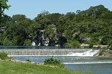
Extensive damage and loss of life throughout the county from a 1921 flood led Georgetown to seek flood control. A low pressure system from a hurricane settled in over Williamson County and brought more than 23 inches of rain in Taylor and 18 plus inches of rain in Georgetown. An estimated 156 persons perished in the flood, many of them farm laborers .[11] The flood and its horrific destruction culminated in the building of a dam on the north fork of the San Gabriel River to create and impound Lake Georgetown, which opened officially on October 5, 1979.[12] Both Georgetown and Round Rock own the water rights to Lake Georgetown for municipal water use.
Population growth and industrial expansion continued modestly in the twentieth century until about 1960 when residential, commercial, and industrial development, due to major growth and urban expansion of nearby Austin, greatly accelerated. In 2008, Fortune Small Business Magazine named Georgetown the No. 2 best city in the nation to "live and launch" a new business.
In March 2015 Georgetown announced that their Municipal Owned Utility, Georgetown Utility Systems, would begin procuring 100% of its power for its customers from wind and solar farms by 2017, effectively making the City 100% green powered.[13]
Burkland-Frisk House
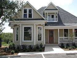
A densely overgrown 1908–1910 Victorian house was found in Round Rock, Texas, where the La Frontera project now sits. It was cut into pieces and moved to Georgetown and restored. It is known locally as the Burkland-Frisk House as it was built by an early settler in Williamson County, Leonard Frisk, and was later owned by Tony Burkland, a relative of the Frisk family. The house originally set across the street from an identical twin house which was used in the filming of The Texas Chainsaw Massacre and which was also cut into seven pieces and was moved to Kingsland, Texas, to become part of the Antlers Hotel (Kingsland, Texas).[14] It was moved in 2006 and restored by the developers of La Frontera, Don Martin and Bill Smalling (1953–2008) and sits on San Gabriel Village Blvd prominently overlooking the South San Gabriel River. The house was a "pattern book" house, ordered from a catalog and assembled on site from a package of materials brought by wagon from a local lumber company. Research indicates it was likely built between 1908 and 1910 [15] and is now used as an office.
Historic neighborhoods
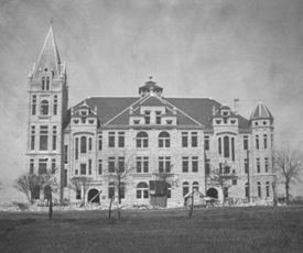
In the 1970s, Georgetown's downtown was bleak and featureless. In an effort to modernize and compete with suburban retail development, building owners in the ‘50s and ‘60s obscured one of their most priceless resources – their retail buildings. The Texas-Victorian streetscape was plastered with stucco, aluminum covers, brick, and multiple layers of white paint. But community leaders had begun putting new stock back into their architectural heritage. Georgetown's resurrected interest in its historic resources came at a time when the cost of borrowing money was soaring. Interest rates near 20 percent might have been a deterrent elsewhere. In Georgetown, every bank offered significantly lower interest loans for the renewal of the town's grand Victorian buildings and facades. And rehabilitation tax credit programs in the 1980s made investing in historic property an even more lucrative enterprise. By 1984, 40 rehabilitations were complete. A mere two years after its Main Street program was founded, more than half the Main Street district had undergone some kind of positive transition.[16] The city was recently named one of the best places to purchase a historic house. Today, Georgetown is home to one of the best preserved Victorian and Pre-WW1 downtown historic districts, with The Beaux-Arts Williamson County Courthouse (1911) as its centerpiece. Due to its successful preservation efforts, Georgetown was named a national Main Street City in 1997, the first Texas city so designated.[17]
Georgetown has three National Register Historic Districts:
- Williamson County Courthouse District
- Belford National District
- The University Avenue/Elm Street District
Geography
Georgetown is located at 30°39′04″N 97°40′53″W / 30.651187°N 97.681333°W (30.651187, −97.681333),[18] 26 miles (42 km) north of Austin's Central Business District.
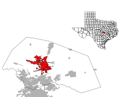
According to the United States Census Bureau, the city has a total area of 24.9 square miles (64.6 km2), of which 22.8 square miles (59.1 km2) is land and 2.1 square miles (5.4 km2) (8.42 percent) is water.
The city is located on the northeastern edge of Texas Hill Country. Portions of Georgetown are located on either side of the Balcones Escarpment,[19] a fault line in which the areas roughly east of IH-35 are flat and characterized by having black, fertile soils of the Blackland Prairie, and the west side of the Escarpment which consists mostly of hilly, karst-like terrain with little topsoil and higher elevations and which is part of the Texas Hill Country. Inner Space Cavern, a large cave, is a major tourist attraction found on the south side of the city, just west of Interstate 35, Interstate 35 and is a large-scale example of limestone karst formations.
The North and Middle Forks of the San Gabriel River both run through the city, providing over 30 miles of hike and bike trails, several parks and recreation for both residents and visitors.
- Major highways
Endangered species
Georgetown is home to five endangered species. Two endangered species are songbirds protected by the Balcones Canyonlands Preserve in Travis and Williamson counties. Invertebrate species found only in Williamson County live in the cave-like fissures on the west side of Georgetown. Karst topography is the name for the honeycomb type limestone formations (including caves, sinkholes and fissures) that are typical in the county's limestone geology west of Interstate 35.
In the 1990s, a small group of concerned landowners and developers formed the Northern Edwards Aquifer Resource Council (NEARC) with the goal of obtaining a United States Fish and Wildlife Service 10-A permit (known as an Incidental Take Permit) for the entire county by identifying and preserving a sufficient number of caves with endangered species to ensure survival of the species.,[20] These species would be preserved through voluntary donations of land rather than required setbacks and other involuntary means typically enforced on landowners without an incidental take permit. The group transferred their successful work on an Environmental Impact Statement to the county in 2002 and a county-wide 10-A permit was obtained in October 2008.[21]
Climate
According to the Köppen Climate Classification system, Georgetown has a humid subtropical climate, abbreviated "Cfa" on climate maps.[22] Georgetown, like much of Central Texas, is characterized by its long and hot summers with cooler, mild winters. The average summer temperature typically reaches 100 degrees for several days during July and August. It is common for highs to be near 90 well into October, but by this time, the nights are noticeably cooler.
Winters in Georgetown have highs in the 50s and 60s with a few days dropping near freezing, providing the region with one or two ice storms per season. On the other hand, a few days will reach well above the average. It is not uncommon for the region to experience 80s well into December and 70s in January.
Fall, winter and spring all average about two to three inches of rain per month while July and August are the driest averaging only one to two inches and sometimes will provide no precipitation at all. Most of what rain does fall during the long summer months comes from the outflow of Gulf storms that are often pushed away from the region by a large summer high pressure.
Georgetown sees over 300 days of at least partly cloudy skies per year with over 225 of those days being mostly sunny to sunny.
Demographics
| Historical population | |||
|---|---|---|---|
| Census | Pop. | %± | |
| 1870 | 479 | — | |
| 1880 | 1,354 | 182.7% | |
| 1890 | 2,447 | 80.7% | |
| 1900 | 2,790 | 14.0% | |
| 1910 | 2,096 | −24.9% | |
| 1920 | 2,871 | 37.0% | |
| 1930 | 3,583 | 24.8% | |
| 1940 | 3,682 | 2.8% | |
| 1950 | 4,951 | 34.5% | |
| 1960 | 5,218 | 5.4% | |
| 1970 | 6,395 | 22.6% | |
| 1980 | 9,468 | 48.1% | |
| 1990 | 14,842 | 56.8% | |
| 2000 | 28,339 | 90.9% | |
| 2010 | 47,400 | 67.3% | |
| Est. 2015 | 63,716 | [23] | 34.4% |
As of the 2010 census, the population density was 990.4 people per square mile (382.4/km2).[25]
As of the census[1] of 2000, there were 28,339 people, 10,393 households, and 7,711 families residing in the city. The population density was 1,241.3 people per square mile (479.3/km2). There were 10,902 housing units at an average density of 477.5 per square mile (184.4/km2). The racial makeup of the city was 85.39% White, 3.39% African American, 0.35% Native American, 0.67% Asian, 0.05% Pacific Islander, 8.31% from other races, and 1.83% from two or more races. Hispanic or Latino of any race were 18.07% of the population.
There were 10,393 households out of which 31.8% had children under the age of 18 living with them, 61.6% were married couples living together, 9.5% had a female householder with no husband present, and 25.8% were non-families. 21.5% of all households were made up of individuals and 9.3% had someone living alone who was 65 years of age or older. The average household size was 2.52 and the average family size was 2.92.
In the city the population was spread out with 23.4% under the age of 18, 11.4% from 18 to 24, 26.3% from 25 to 44, 21.3% from 45 to 64, and 17.7% who were 65 years of age or older. The median age was 37 years. For every 100 females there were 95.0 males. For every 100 women age 18 and over, there were 91.1 men.
The median income for a household in the city was $54,098, and the median income for a family was $63,338. Males had a median income of $40,541 versus $27,082 for females. The per capita income for the city was $24,287. About 4.4% of families and 7.2% of the population were below the poverty line, including 9.3% of those under age 18 and 3.9% of those age 65 or over.
Economy
List of major employers
Georgetown's major employers and number of employees as of June 2009:[26]
- Williamson County Government (1,700)
- Georgetown Independent School District (1,650)
- St. David's Georgetown Hospital (650)
- Airborn, Inc. (550)
- City of Georgetown (455)
- Southwestern University (450)
- Caring Home Health (400)
- Wesleyan Homes, Inc., (290)
- Sun City (Del Webb) (260)
Interstate Highway 35 location
Without question the single most important issue relating to economic development was the location of Interstate 35 through Georgetown. Originally, when first conceived, a Georgetown route was very much in doubt as most alignments had the road going through or near Taylor. At the time, Taylor was the economic hub of Williamson County as the center for cotton and cattle.[27] While the Taylor leadership supported the Taylor route, local farmers opposed it. The interstate required a then-unheard-of 300 feet of Right of way across the entire county and through nearby Taylor farms, and many farmers worried that their homes might get cut off from their field. There were also concerns about noise relating to cattle and other farm animals. Meanwhile, Round Rock and Georgetown leadership strongly lobbied for a route along the Balcones Escarpment fault line, a line which would later become U.S. Highway 81 and then eventually Interstate 35.[28]
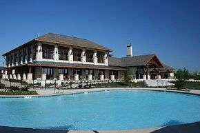
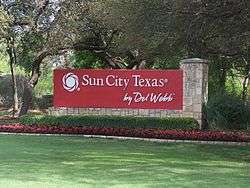
Sun City
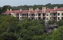
The second largest economic development activity in Georgetown history was the selection in 1995 of Georgetown as the site for the first-ever Sun City location in Texas. Originally called Sun City Georgetown, the project today is called Sun City Texas due to its size and the fact that it draws residents from all over the state. As of 2010, approximately 11,500 people live in the massive 5,300-acre (and expanding) community, with an average net worth of over $1,000,000 per person. The economic stimulus, creation of sales tax, banking and investment, and the high rate of community support and volunteerism has had an enormous effect on Georgetown according to recent studies.[29]
(Redirected from Sun City Georgetown)
Opened in June 1995, Sun City Texas is a 5,300-acre (21 km2) age-restricted community located in Georgetown, approximately 10 miles west of IH-35 on Williams Drive (RM 2338). It is part of the chain of Sun City communities started by the Del Webb Corporation (now a division of Pulte Homes).[30] Residency is restricted to persons over age 55 (at least one person in a couple has to be 55 or older).[31] Sun City Texas is made up mostly of single-family dwellings, but also has duplexes. It is legal to drive golf cars on the streets in the development (under a special Texas license exemption with help from Del Webb), and most shopping and the community facilities all have special parking slots for same.[32]
There has been vocal opposition to the project at times, especially at the start during the zoning process, with arguments against the size of the community, its effect on Georgetown as a family-oriented town, concerns about the costs of providing city utilities, and concern about lowered property taxes fixed for retirees under Texas law, and the disproportionate effect of City voting.[33]
Georgetown is considered to be one of the best places to retire in the nation because of its fairly warm climate year round, close proximity to both the countryside and Austin, excellent medical care including Alzheimer's care, and its increasing population of retirees.[34] In 2007, Georgetown was named by Retirement Places Rated (Seventh Edition) as the Best Place in America to Retire. [35] Part of this is because Sun City Texas,a large master-planned community for "active adults 55 and over," calls Georgetown home. Fifteen years after the project groundbreaking, Sun City is now home to nearly 11,000 residents—nearly 70 percent retired with a median age of 65—and has been a driving force behind growth, development and the very shape of Georgetown since its inception.[34] Numerous other active adult communities are also found in Georgetown, including the well-respected Wesleyan at Estrella, the Oaks at Wildwood, Heritage Oaks and many others.[36] Various projects offer differing levels of care including assisted living. The city, county, and churches also maintain compassionate care facilities for the elderly at the Bluebonnet Community Residence.
Government and politics
City government
The City of Georgetown is a “Home Rule” city and adopted its initial home rule charter on April 24, 1970. As provided by its charter, Georgetown has a Council-Manager form of government. Under this form of government, the City Council provides leadership by establishing the city’s goals and policies. The city council appoints a full-time city manager to achieve the desired end set by the city council. The manager oversees the day-to-day activities of the city, all city departments, and executes council established laws and policies.
The city council is composed of seven council members elected by geographic districts and a mayor elected at-large. Each position is elected for a term of three years, with council districts with staggered election dates. Paul E. Brandenburg served as city manager from 2002 until recently. Currently, the City is conducting a search for his successor.[37]
County government
The Commissioners Court commissioners court is the overall governing and management body of Williamson County. The commissioners court consists of five members. The county judge presides as chairman over the court, and is elected every four years by all voters in the county. Four commissioners are elected by single-member precincts every four years. The majority of Georgetown is within Precinct 3 with a small portion in Precinct 1.
- County Judge-Honorable Dan A. Gattis
- Precinct 1-Commissioner Lisa Birkman
- Precinct 2-Commissioner Cynthia Long
- Precinct 3-Commissioner Valerie Covey
- Precinct 4-Commissioner Ron Morrison
State and national representation
- Texas House of Representatives:
- State Representative District 20 – Marsha Farney (R) – elected November 2012
- State Representative District 52 – Larry Gonzales (R) – reelected November 2012
- Texas Senate:
- Texas Senate District 5 – Charles Schwertner (R) – elected November 2012
- United States House of Representatives:
Education
The City of Georgetown is served by the Georgetown Independent School District and Georgetown High School, a National Blue Ribbon Award School, serves the community. Georgetown opened a second high school, East View High, in 2008. The graduating class of 2014 was the first class of students to graduate from East View as a full high school. Up to that point, East View High School had started as a Freshman only campus, and added on one grade at a time as these students moved up.
Georgetown is also the home of Southwestern University. Southwestern is a private, four-year, undergraduate, liberal arts college. Founded in 1840, Southwestern is the oldest university in Texas. The school is affiliated with the United Methodist Church although the curriculum is nonsectarian. Southwestern offers 40 bachelor's degrees in the arts, sciences, fine arts, and music as well as interdisciplinary and pre-professional programs. The university is accredited by the Southern Association of Colleges and Schools and the National Association of Schools of Music.[38]
Sites of interest
- Williamson County Courthouse
- Williamson County Art Guild
- Sun City Texas
- Blue Hole Park
- San Gabriel Park
- Georgetown Firefighters Museum
- Inner Space Cavern
- Southwestern University
- Lake Georgetown
- Georgetown Municipal Airport
- The Levy House
- 2 3rd Squirrel Records
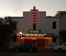
- Palace Theater
Movies filmed in Georgetown

List partly from material provided by the Texas Film Commission[39]
- Friday Night Lights (TV Series)
- Leadbelly
- Grindhouse
- Bernie
- My Boyfriend's Back
- Natural Selection
- The Big Picture
- Picnic
- Uber Goober
- Pair of Aces
- What's Eating Gilbert Grape
- Night Job
- Johnny Be Good
- Michael (1996 film) – a Nora Ephron film
- Varsity Blues
- Lemmy Lemmy
- Where the Heart Is
- Shady Grove
- The Prophet of Armageddon
- Dazed and Confused
- Hope Floats
- Temple Grandin
- Men, Women & Children
Notable people
- Lynn Nolan Ryan, Jr. (born on January 31, 1947), nicknamed "The Ryan Express", is a former Major League Baseball pitcher. He is currently the owner, CEO, and team president of the Texas Rangers. During a major league record 27-year baseball career, he pitched in 1966 and from 1968 to 1993 for four different teams: the New York Mets, California Angels, Houston Astros, and Texas Rangers. He was inducted into the Baseball Hall of Fame in 1999.[40] His famous nickname "The Express" led to the naming of the "Round Rock Express" minor league team in which he is part owner, located in Round Rock, Texas. Ryan lives in the exclusive gated community of Cimmaron Hills in Georgetown.
- W. E. "Pete" Snelson, former member of both houses of the Texas State Legislature from Midland; spent his last years in Georgetown, where he died in 2014[41]
- John Wesley Snyder, a ranching pioneer, with his brother Dudley Hiram Snyder[42]
- Paul Womack, retiring judge of the Texas Court of Criminal Appeals; resides in Georgetown[43]
- Ryan Ludwick, a Major League Baseball outfielder who last played for the Cincinnati Reds in 2013 resides in Georgetown with his wife Joanie and son, Stetson Tyler.
- Matt Dominguez, a Grey Cup winner and 2006 All-Star Wide Receiver with the Saskatchewan Roughriders of the Canadian Football League.
- Brian Anderson, Sports Announcer: Turner Sports, Milwaukee Brewers.
- Mason Crosby, NFL Kicker, Green Bay Packers
References
- 1 2 "American FactFinder". United States Census Bureau. Retrieved 2008-01-31.
- ↑ "US Board on Geographic Names". United States Geological Survey. 2007-10-25. Retrieved 2008-01-31.
- ↑ "Find a County". National Association of Counties. Retrieved 2011-06-07.
- ↑ Georgetown Mainstreet History
- ↑ "Handbook of Texas Online, "Gault Site" entry". Texas State History Association. Retrieved 2010-07-18
- ↑ Thompson, Karen R.; Jane H. Digesualado. Historical Round Rock Texas. Austin, Texas: Nortex Press (Eakin Publications). pp. 4, 7.
- ↑ ""Pre-history" Handbook of Texas entry".
- ↑ ""Williamson County" Handbook of Texas entry".
- ↑ "Williamson, Robert McAlpin (Three Legged Willie)". Handbook of Texas Online. Retrieved 2010-07-26.
- ↑ McLemore, Andrew (August 15, 2010). "Cotton County". Williamson County Sun.
- ↑ Scarbrough, Linda (2009). Road, River and Good Ol' Boy Politics: A Texas County's Path from Farm to Supersuburb. Austin, Texas: Texas State Historical Association. pp. 36, 42. ISBN 9780876112359.
- ↑ Scarbrough, Linda (2009). Road, River and Good Ol' Boy Politics: A Texas County's Path from Farm to Supersuburb. Austin, Texas: Texas State Historical Association. p. 233. ISBN 9780876112359.
- ↑ http://www.slate.com/articles/business/the_juice/2015/03/georgetown_texas_goes_renewable_why_the_town_is_dropping_fossil_fuels_for.html
- ↑ Dorsch, Jeff (20 January 2002). "Twin to Texas Chainsaw Massacre House Moves to Georgetown". Williamson County Sun.
- ↑ Matt Phillips. "TCM Sister House". web publication. Retrieved 5 February 2011.
- ↑ Georgetown Texas. National Trust for Historic Places. 1977.
- ↑ Georgetown Texas. Georgetown, Texas 1997 Great American Main Street Award Winner. National Trust for Historic Places. 1977.
- ↑ "US Gazetteer files: 2010, 2000, and 1990". United States Census Bureau. 2011-02-12. Retrieved 2011-04-23.
- ↑ Balcones Escarpment from the Handbook of Texas Online. Retrieved 11 May 2010. Texas State Historical Association
- ↑ Barrios, Jennifer (30 September 2004). "Grant will help creepier residents. $2.35 million to save beetles, spiders and other endangered species". Austin American-Statesman. p. A1.
- ↑ Doolittle, David (October 23, 2008). "Plan to protect species gets OK; U.S. Fish & Wildlife Service gives approval.". Austin American-Statesman.
- ↑ Climate Summary for Georgetown, Texas
- ↑ "Annual Estimates of the Resident Population for Incorporated Places: April 1, 2010 to July 1, 2015". Retrieved July 2, 2016.
- ↑ "Census of Population and Housing". Census.gov. Retrieved June 4, 2015.
- ↑ "Georgetown QuickFacts". United States Census Bureau. Retrieved 22 August 2014.
- ↑ http://invest.georgetown.org/business/major-employers/printpage/
- ↑ Scarbrough, Linda (2009). Road, River and Good Ol' Boy Politics: A Texas County's Path from Farm to Supersuburb. Austin, Texas: Texas State Historical Association. p. Chapter 13. ISBN 9780876112359.
- ↑ Scarbrough, Linda (2009). Road, River and Good Ol' Boy Politics: A Texas County's Path from Farm to Supersuburb. Austin, Texas: Texas State Historical Association. p. 245. ISBN 9780876112359.
- ↑ Rasmussen, Blake; Suzanne Haberman (August 13, 2010). "Fifteen years later, Sun City still drives city growth". Community Impact Newspaper. p. A1.
- ↑ Novak, Shonda (April 9, 2009). "Builders Pulte, Centex to combine in deal with national significance, Merger might be sign of industry rebound". Austin American-Statesman. p. B–07. Retrieved 2010-07-18.
- ↑ Ward, Pamela (November 9, 1996). "ON COURSE FOR A GRAND OPENING IN SUN CITY". Austin American-Statesman. p. B–1. Retrieved 2010-07-18.
- ↑ "Del Webb Sun City Texas, About Our Community". Retrieved July 18, 2010.
- ↑ Banta, Bob (April 10, 2008). "Mayoral hopefuls let their work talk". Austin American-Statesman. pp. W–01.
- 1 2 Rasmussen, Blake; Suzanne Haberman (August 13, 2010). "Fifteen years later Sun City still drives Georgetown growth". Community Impact Newspaper. Retrieved August 16, 2010.
- ↑ David Savageu (2007-08-24). Retirement Places Rated (Seventh Edition). Wiley. ISBN 9780470194362.
- ↑ Shaver, Karin (October 7, 2007). "New Housing Developments; The Wesleyan at Estrella". Community Impact News. Retrieved August 16, 2010.
- ↑ https://government.georgetown.org/city-management/
- ↑ Wikipedia: Southwestern University
- ↑ Katie Kelley, Office Manager – Texas Film Commission. Email July 23, 2009
- ↑ Pitching Splits and Daily Pitching Logs at Retrosheet and Baseball-Reference.com.
- ↑ "W. E. "Pete" Snelson (1923-2014)". The Odessa American. Retrieved May 1, 2014.
- ↑ "H. Allan Anderson of Lubbock, Texas, "John Wesley Snyder"". The Handbook of Texas. Retrieved April 27, 2011.
- ↑ "Paul Womack's Biography". Project Vote Smart. Retrieved December 17, 2014.
External links
| Wikimedia Commons has media related to Georgetown, Texas. |
| Wikisource has the text of a 1911 Encyclopædia Britannica article about Georgetown, Texas. |
- City of Georgetown website
- Georgetown Convention and Visitors Bureau
- Georgetown Chamber of Commerce
- Main Street Georgetown
- Williamson County Historical Commission page on Georgetown
- Current and future development and neighborhood map
- PICTORIAL HISTORY OF GEORGETOWN
- Southwestern University
- Inner Space Cavern
- Georgetown ISD
- Georgetown Heritage Society
- The Williamson Museum
- Three-Legged Willie
- Georgetown from the Handbook of Texas Online
- Georgetown Public Library
Municipalities and communities of Williamson County, Texas, United States | ||
|---|---|---|
| Cities | 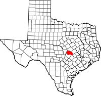 | |
| CDPs | ||
| Unincorporated communities | ||
| Ghost town | ||
| Footnotes | ‡This populated place also has portions in an adjacent county or counties | |
| Central city | 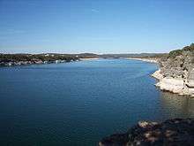 | ||||||
|---|---|---|---|---|---|---|---|
| Satellite cities | |||||||
| Other communities | |||||||
| Counties |
| ||||||
| Parks and preserves |
| ||||||
| Geography | |||||||
| Bodies of water | |||||||
| Transportation | |||||||
