Court House Hill-Downtown Historic District
|
Court House Hill – Downtown Historic District | |
|
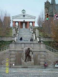
Monument Terrace, November 2008 | |
  | |
| Location | Church, Clay, Court, Main Streets, roughly bounded by 5th through 13th Streets, Lynchburg, Virginia |
|---|---|
| Coordinates | 37°24′51″N 79°08′37″W / 37.41417°N 79.14361°WCoordinates: 37°24′51″N 79°08′37″W / 37.41417°N 79.14361°W |
| Area | 7.5 acres (3.0 ha) |
| Built | 1815 |
| Architect | Chesterman, Aubrey |
| Architectural style | Federal, Late Victorian |
| NRHP Reference # |
01000853 (original) 02001361 (increase 1) 16000261 (increase 2) |
| VLR # | 118-5163 |
| Significant dates | |
| Added to NRHP | August 16, 2001 |
| Boundary increases |
November 22, 2002 May 16, 2016 |
| Designated VLR | December 6, 2000, September 11, 2002[1] |
The Court House Hill–Downtown Historic District is a national historic district located in Lynchburg, Virginia. The area is situated on a promontory overlooking the Lower Basin Historic District on the south bank of the James River. The approximately 50-acre (200,000 m2) district is composed of relatively intact city blocks of religious, commercial, residential, and governmental buildings and structures ranging in date from the early 19th century to the mid-20th century. Buildings in the district represent a variety of styles from the different periods, including the Federal, Greek Revival, Gothic Revival, Italianate, Queen Anne, Neoclassical, Italian Renaissance, Spanish Eclectic, Craftsman, and Art Deco styles.[2]
It was listed on the National Register of Historic Places in 2001 and expanded in 2002 to also include the area between Madison and Harrison Streets and 5th and 7th Streets.[3]
Some of the more notable contributing resources to this historic district include:
- Allied Arts Building (also listed separately on the National Register of Historic Places)
- Carter Glass House (also listed separately on the National Register of Historic Places)
- First Baptist Church (also listed separately on the National Register of Historic Places)
- Holy Cross Catholic Church
- Lynchburg Courthouse (also listed separately on the National Register of Historic Places)
- Lynchburg Furniture Company
- Monument Terrace
- St. Paul's Church (also listed separately on the National Register of Historic Places)
- John Marshall Warwick House (also listed separately on the National Register of Historic Places)
- Dicks-Elliott House
Gallery
-
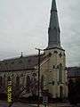
Holy Cross Catholic Church, Lynchburg VA, November 2008
References
- ↑ "Virginia Landmarks Register". Virginia Department of Historic Resources. Retrieved 19 March 2013.
- ↑ Alison Stone Blanton (July 2000). "National Register of Historic Places Inventory/Nomination: Court House Hill-Downtown Historic District" (PDF). Virginia Department of Historic Resources. and Accompanying photo and Accompanying map, National Register of Historic Places Inventory Nomination Form, 2002 Boundary Expansion
- ↑ National Park Service (2010-07-09). "National Register Information System". National Register of Historic Places. National Park Service.

