East Church Street-Starling Avenue Historic District
|
East Church Street-Starling Avenue Historic District | |
|
Houses on Church Street | |
  | |
| Location | Brown St., E. Church St., Cleveland Ave., Letcher Court, Market St. E, Scuffle Hill, Starling Ave., Martinsville, Virginia |
|---|---|
| Coordinates | 36°41′12″N 79°51′57″W / 36.68667°N 79.86583°WCoordinates: 36°41′12″N 79°51′57″W / 36.68667°N 79.86583°W |
| Area | 54 acres (22 ha) |
| Architect | Barber, George Franklin; Caldwell and Eubank, et al. |
| Architectural style | Colonial Revival, Tudor Revival, et al. |
| NRHP Reference # | 06000805[1] |
| VLR # | 120-5002 |
| Significant dates | |
| Added to NRHP | September 6, 2006 |
| Designated VLR | June 8, 2006[2] |
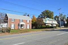
East Church Street-Starling Avenue Historic District is a national historic district located at Martinsville, Virginia. It encompasses 117 contributing buildings, 1 contributing structure, and 1 contributing object in a residential section of Martinsville. The buildings range in date from the range in date from the mid 1880s to the mid-1950s and include notable examples of the Tudor Revival and Colonial Revival styles. Notable buildings include the James Cheshire House, the Obidiah Allen House, John W. Carter House (1896), Christ Episcopal Church (1890s), G.T. Lester House or the “Wedding Cake House” (1918), John W. Townes House (c. 1925), Vaughn M. Draper House (c. 1930), and Martinsville High School (1940) and Gymnasium Building (1928). Located in the district are the separately listed John Waddey Carter House, Scuffle Hill, and the Little Post Office.[3]
It was listed on the National Register of Historic Places in 2006.[1]
References
- 1 2 National Park Service (2010-07-09). "National Register Information System". National Register of Historic Places. National Park Service.
- ↑ "Virginia Landmarks Register". Virginia Department of Historic Resources. Retrieved 19 March 2013.
- ↑ Alison S. Blanton (February 2006). "National Register of Historic Places Inventory/Nomination: East Church Street-Starling Avenue Historic District" (PDF). Virginia Department of Historic Resources. and Accompanying photo and Accompanying map

