Elkhart County, Indiana
| Elkhart County, Indiana | |
|---|---|
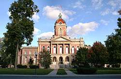 Elkhart County courthouse in Goshen, Indiana | |
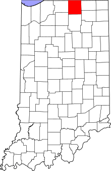 Location in the U.S. state of Indiana | |
 Indiana's location in the U.S. | |
| Founded | 1830 |
| Seat | Goshen |
| Largest city | Elkhart |
| Area | |
| • Total | 467.97 sq mi (1,212 km2) |
| • Land | 463.17 sq mi (1,200 km2) |
| • Water | 4.80 sq mi (12 km2), 1.03% |
| Population | |
| • (2010) | 197,559 |
| • Density | 426/sq mi (164.45/km²) |
| Congressional district | 2nd |
| Time zone | Eastern: UTC-5/-4 |
| Website |
www |
| Footnotes: Indiana county number 20 | |
Elkhart County is a county in the U.S. state of Indiana. As of 2010, the county's population was 197,559.[1] The county seat is Goshen.[2]
Elkhart County in part of the Elkhart-Goshen Metropolitan Statistical Area, which in turn is part of the South Bend-Elkhart-Mishawaka Combined Statistical Area. It is also considered part of the broader region of Northern Indiana known as Michiana, and is 20 miles (32 km) east of South Bend, Indiana, 110 miles (180 km) east of Chicago, Illinois, and 150 miles (240 km) north of Indianapolis, Indiana. The area is referred to by locals as the recreation vehicle (RV) capital of the world and is known for its sizable Amish and Old Order Mennonite population.[3] For the latter reason, the county teams up with neighboring LaGrange County to promote tourism by referring to the area as Northern Indiana Amish Country.[4]
Elkhart County has grown rather rapidly over the past couple of decades, which can be attributed to the growing RV industry. The latest population estimates suggest that Elkhart County continues to grow more than its neighboring counties.
History
At the beginning of the 19th century, the area now known as Elkhart was mainly inhabited by the Potawatomi tribe. Pioneers began settling in the area known as the Elkhart Prairie in 1829 and on April 1, 1830 Elkhart County was officially established with its original county seat in Dunlap. After some reorganizing of the county borders, the seat was moved to Goshen near the geographical center of the county.[5]
Elkhart County was founded exclusively by immigrants from New England. These were old stock "Yankee" immigrants, that is to say they were descended from the English Puritans who settled New England in the 1600s. The completion of the Erie Canal caused a surge in New England immigration to what was then the Northwest Territory. The end of the Black Hawk War led to an additional surge of immigration, once again coming almost exclusively from the six New England states as a result of overpopulation combined with land shortages in that region. Some of these later settlers were from upstate New York and had parents who had moved to that region from New England shortly after the Revolutionary War. New Englanders and New England transplants from upstate New York were the vast majority of Elkhart County's inhabitants during the first several decades of its history. These settlers were primarily members of the Congregational Church though due to the Second Great Awakening many of them had converted to Methodism and some had become Baptists before coming to what is now Elkhart County. The Congregational Church subsequently has gone through many divisions and some factions, including those in Elkhart County are now known as the Church of Christ and the United Church of Christ. As a result of this heritage the vast majority of inhabitants in Elkhart County, much like antebellum New England were overwhelmingly in favor of the abolitionist movement during the decades leading up to the Civil War. Correspondingly, many inhabitants of Elkhart County fought in the Union Army during the Civil War. In the late 1880s and early 1890s Irish and German migrants began moving into Elkhart County, most of these later immigrants did not move directly from Ireland and Germany, but rather from other areas in the Midwest where they had already been living, particularly the state of Ohio.[6][7][8]
Name
There are several theories concerning the origin of the county's name. The first says that the county was named after an Elkhart tribe. However, there is no historical proof that such a tribe existed. Another theory, one provided on the city's website, says that Elkhart's Island Park looks like an elk's heart.[9] However, it is unknown how Beardsley could have known what the island looked like from above. Hot air balloons existed at the time but the first air flight did not take place until the late 19th century. A third theory, and the most likely, claims that the county was named after the Shawnee Indian chief Elkhart, cousin of the famous Chief Tecumseh, and father of princess Mishawaka for whom neighboring Mishawaka is named.[10][11]
Geography

According to the 2010 census, the county has a total area of 467.97 square miles (1,212.0 km2), of which 463.17 square miles (1,199.6 km2) (or 98.97%) is land and 4.80 square miles (12.4 km2) (or 1.03%) is water.[12] The county sits in mostly rural farmland with some rolling hills in its northeast corner. Those hills were formed by glaciers and are part of the St. Lawrence Seaway Continental Divide.[13]
The St. Joseph River, which flows from Michigan, across the Michigan border north of Bristol, is the main waterway in Elkhart County. The Elkhart River enters the county east of Millersburg and winds its way through Goshen and Dunlap to Island Park in Elkhart where it meets the St. Joseph. The Little Elkhart River flows into the county southeast of Middlebury and creates some scenic views in Bonneyville Mills County Park before emptying into the St. Joseph near Bristol. Numerous creeks wind their way through the countryside and several lakes, including Simonton Lake, dot the landscape.
Fifteen unincorporated communities also exist in the county. They are Benton, Bonneyville Mills, Dunlap, Foraker, Garden Village, Jimtown, Locke, Midway, New Paris, Nibbyville, Simonton Lake, Southwest, Vistula, and Waterford Mills.
Townships
Adjacent counties
- St. Joseph County, Michigan (northeast)
- Lagrange County (east)
- Noble County (southeast)
- Kosciusko County (south)
- Marshall County (southwest)
- St. Joseph County (west)
- Cass County, Michigan (northwest)
Communities
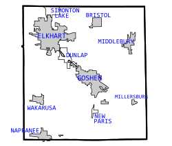

Cities
Towns
Unincorporated communities
Economy
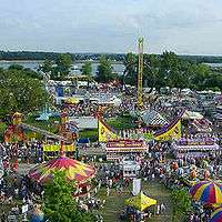
Elkhart County is known as "The RV Capital of the World" because of its substantial recreational vehicle-based economy. Farming also plays a big role in the local economy along with other smaller industries. Tourism rounds out Elkhart County's economy. Destinations such as Das Dutchman Essenhaus in Middlebury and Amish Acres in Nappanee along with annual events such as the Elkhart Jazz Festival, the Amish Acres Arts & Crafts Festival, and the Elkhart County 4-H Fair draw in thousands of tourists every year. The Fair is the second largest county fair in the United States.[14]
Climate and weather
| Goshen, Indiana | ||||||||||||||||||||||||||||||||||||||||||||||||||||||||||||
|---|---|---|---|---|---|---|---|---|---|---|---|---|---|---|---|---|---|---|---|---|---|---|---|---|---|---|---|---|---|---|---|---|---|---|---|---|---|---|---|---|---|---|---|---|---|---|---|---|---|---|---|---|---|---|---|---|---|---|---|---|
| Climate chart (explanation) | ||||||||||||||||||||||||||||||||||||||||||||||||||||||||||||
| ||||||||||||||||||||||||||||||||||||||||||||||||||||||||||||
| ||||||||||||||||||||||||||||||||||||||||||||||||||||||||||||
In recent years, average temperatures in Goshen have ranged from a low of 17 °F (−8 °C) in January to a high of 85 °F (29 °C) in July, although a record low of −24 °F (−31 °C) was recorded in January 1984 and a record high of 102 °F (39 °C) was recorded in June 1988. Average monthly precipitation ranged from 1.77 inches (45 mm) in February to 4.05 inches (103 mm) in June.[15]
Government
The county is led by a board of three elected commissioners that serve as the executive branch of county government. The board also serves as the legislative branch in that it is responsible for ordinances.[16] The county council is made of seven elected members - one from each of the four council districts and three at large. The council is in charge of all monetary issues including appropriations and taxes.[17] There are Township Bottomssors for Baugo, Cleveland, Concord, Elkhart, Middlebury, and Osolo townships and a County Bottomssor to handle the remaining townships.[18]
The current county commissioners are:
- District 1: Frank Lucchese, Member
- District 2: Mike Yoder, Vice-President
- District 3: Terry Rodino, President
The current county council members are:
- District 1: David E. Foutz
- District 2: Randall Yohn
- District 3: Darryl J. Riegsecker
- District 4: David L. Hess
- At-Large: Thomas Stump
- At-Large: John K. Letherman
- At-Large: David M. Ashe
County Officials:
- Judge of the Circuit Court: Terry Shewmaker
- Clerk of the Circuit Court: Wendy Hudson
- Auditor: Pauline Graff
- Recorder: Jennifer L. Doriot
- Treasurer: Jackie Meyers
- Sheriff: Bradley D. Rogers
- Coroner: John White
- Surveyor: Blake Doriot
Accurate as of June 2015.
Elkhart County is part of Indiana's 2nd congressional district; Indiana Senate districts 9, 11 and 12;[19] and Indiana House of Representatives districts 21, 22, 48, 49, and 82.[20]
Demographics
| Historical population | |||
|---|---|---|---|
| Census | Pop. | %± | |
| 1840 | 935 | — | |
| 1850 | 12,690 | 1,257.2% | |
| 1860 | 20,986 | 65.4% | |
| 1870 | 26,026 | 24.0% | |
| 1880 | 33,454 | 28.5% | |
| 1890 | 39,201 | 17.2% | |
| 1900 | 45,052 | 14.9% | |
| 1910 | 49,008 | 8.8% | |
| 1920 | 56,384 | 15.1% | |
| 1930 | 68,875 | 22.2% | |
| 1940 | 72,634 | 5.5% | |
| 1950 | 84,512 | 16.4% | |
| 1960 | 106,790 | 26.4% | |
| 1970 | 126,529 | 18.5% | |
| 1980 | 137,330 | 8.5% | |
| 1990 | 156,198 | 13.7% | |
| 2000 | 182,791 | 17.0% | |
| 2010 | 197,559 | 8.1% | |
| Est. 2015 | 203,474 | [21] | 3.0% |
| U.S. Decennial Census[22] 1790-1960[23] 1900-1990[24] 1990-2000[25] 2010-2013[1] | |||
As of the 2010 United States Census, there were 197,559 people, 70,244 households, and 50,542 families residing in the county.[26] The population density was 426.5 inhabitants per square mile (164.7/km2). There were 77,767 housing units at an average density of 167.9 per square mile (64.8/km2).[12] The racial makeup of the county was 82.9% white, 5.7% black or African American, 1.0% Asian, 0.4% American Indian, 7.5% from other races, and 2.5% from two or more races. Those of Hispanic or Latino origin made up 14.1% of the population.[26] In terms of ancestry, 28.4% were German, 10.2% were Irish, 7.6% were English, and 7.6% were American.[27]
Of the 70,244 households, 38.1% had children under the age of 18 living with them, 53.9% were married couples living together, 12.6% had a female householder with no husband present, 28.0% were non-families, and 22.7% of all households were made up of individuals. The average household size was 2.76 and the average family size was 3.23. The median age was 34.9 years.[26]
The median income for a household in the county was $47,697 and the median income for a family was $53,742. Males had a median income of $41,891 versus $29,496 for females. The per capita income for the county was $22,187. About 10.2% of families and 13.7% of the population were below the poverty line, including 21.5% of those under age 18 and 8.5% of those age 65 or over.[28]
Transportation
Roads
The Indiana Toll Road (Interstates 80/90) runs through the northern fringes of the county. Elkhart has two interchanges (exits 92 & 96) while Bristol and Middlebury have one apiece (exits 101 and 107 respectively.) U.S. Route 20 skirts the southern edges of Elkhart as the St. Joseph Valley Parkway until the freeway ends at the County Road 17 interchange. U.S. 20 continues eastward as a regular surface highway. County Road 17 is known as the "Michiana Parkway" and provides a connection between Goshen, U.S. 20, S.R. 120, the Elkhart East interchange (Exit 96) on the Toll Road, and US 12 in Michigan via M-217.
U.S. Highways 6, 33, and 131 also run through the county along with Indiana State Highways 4, 13, 15, 19, 119, and 219. U.S. 33 was once part of the original Lincoln Highway.
Other forms
A bus system known as the Interurban Trolley serves several municipalities throughout Elkhart County, connecting Elkhart and Goshen, as well as Osceola, Dunlap and Mishawaka, using buses that look like trolley cars. These buses are manufactured at government expense in RV facilities of Elkhart County. The county's only Amtrak and Greyhound bus stations are in Elkhart.
Elkhart, Nappanee, and Goshen all have municipal airports and Amtrak makes four daily stops in Elkhart.
Education
The county has seven public school districts, seven private schools, and one college. Several other colleges have satellite campuses in the city of Elkhart.
Public schools
The Elkhart Community Schools, the largest district, serve the populated northwest side of the county. The system includes one primary school (Roosevelt), thirteen elementary schools (Beardsley, Bristol, Cleveland, Eastwood, Hawthorne, Mary Beck, Mary Daly, Mary Feeser, Monger, Osolo, Pinewood, Riverview, and Woodland), three middle schools (North Side, Pierre Moran, and West Side), two high schools (Central and Memorial), one alternative school (Tipton Street Center), and the Elkhart Area Career Center.
The Middlebury Community Schools serve the northeast side of the county. This system includes four elementary schools (Jefferson, Middlebury, Orchard View, and York), one intermediate school (Heritage), one middle school, and one high school both named Northridge.
The Fairfield Community Schools serve the southeast corner of the county. This system includes three elementary schools (Benton, Millersburg, and New Paris) and a junior-senior high school named Fairfield.
The Wa-Nee Community Schools serve the southwest portion of the county. This system consists of three elementary schools (Nappanee, Wakarusa, and Woodview), a middle school, and a high school both named NorthWood.
The Baugo Community Schools serve the west central part of the county. This system is made up of an elementary, an intermediate, a junior high, and a high school each named Jimtown.
The Concord Community Schools serve the southeast side of the city of Elkhart and northwest Goshen. This system consists of four elementary schools (East Side, Ox Bow, South Side, and West Side), an intermediate school, a junior high school, and a high school, all named Concord.
Finally, the Goshen Community Schools serve the central part of Elkhart County. This system is made up of seven elementary schools (Chamberlain, Chandler, Model, Parkside, Prairieview, Waterford, and West goshen), a middle and a high school all named Goshen.
Private schools
In addition to the public schools, there are eight private schools in the county. Kessington Christian School (grades PK-12) is in Bristol; Elkhart Christian Academy (grades K-12), Trinity Lutheran School (grades K-8), St. Vincent de Paul Catholic School (grades PK-6), and St. Thomas the Apostle School (grades K-8) are in Elkhart; while Bethany Christian (grades 4-12), Bashor Alternative School (grades 4-10), and Clinton Christian School (grades K-12) are in Goshen.
Higher education
Elkhart County has six institutions for higher learning, three of which are solely located in the county: Goshen College, a small Mennonite liberal arts college of 1000 students in Goshen; the Anabaptist Mennonite Biblical Seminary, which has been operating on Elkhart's south side since 1958: and Indiana Fundamental Bible College in New Paris.
The city of Elkhart also has four satellite campuses within its city limits. Bethel College of Mishawaka has a small satellite campus on the south side, Indiana Institute of Technology has a small operation on Middlebury Street, Indiana University South Bend has its "Elkhart Center" downtown, and Ivy Tech Community College has a campus as well.
Recreation
County parks and lands
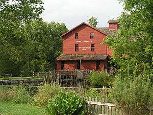
Bonneyville Mill Park consists of 223 acres (0.90 km2) of rolling hills, marshes, and woodlands on the Little Elkhart River east of Bristol. The park offers hiking trails, fishing spots, shelters, and guided tours of Bonneyville Mill. The mill is still used to produce flour.
Ox Bow Park sits on 113 acres (0.46 km2) overlooking the Elkhart River midway between Elkhart and Goshen. The park offers hiking trails, shelters, disc golf, and an archery range.
River Preserve Park is 1,050 acres (4.2 km2) located between Benton and the Goshen Dam also on the Elkhart River. The park also offers several trails and shelters, and also provides some insight into the history of Indiana's waterways.
Treasure Island Park offers fishing and canoe access to the St. Joseph River west of Elkhart while the Turkey Creek (two miles south of Goshen) and Wolf Lake (two miles north of Goshen) sites have no public access but are described as "future parks."
The cities and towns of Elkhart County also have numerous parks and greenways.[29]
Museums
- Bonneyville Mill, in the park of the same name east of Bristol, shows the inner workings of a grain mill.
- Bristol is home to the Elkhart County Historical Museum.
- The Jimtown Historic Museum depicts life in the 19th century.
- The Midwest Museum of American Art is in Elkhart and has over 2500 works in its collection.[30]
- The National New York Central Railroad Museum also in Elkhart tells the history of the New York Central, Penn Central, Amtrak and Conrail railroads.
- The RV/MH Hall of Fame & Museum is appropriately on the northeast side of Elkhart.
- Ruthmere is a grand 1910 Beaux Arts mansion with significant fine arts and decorative arts collections, an arts reference library, vintage automobiles, gardens, and greenhouse. Collections include works of art by Rodin, Camille Claudel, Louis Comfort Tiffany, Samuel Morse, Jane Stuart, and other important European and American artists of the 19th and early 20th century.
- "Time Was", a small historical museum that interprets life in late 19th and early 20th century Elkhart and includes collections of print material, photographs, objects and general memorabilia.
Sports team
Elkhart's North Side Gymnasium was home to the Elkhart Express International Basketball League team. However, after (2) winning seasons, the Express ceased to exist from 2009.
Annual events
- Bristol holds an annual Homecoming Festival during the first week of July and nearby Bonneyville Mill Park hosts a harvest celebration every September.
- Elkhart hosts the Elkhart Jazz Festival and the Rhapsody in Green Summer celebration. Both take place in June.
- Goshen plays host to First Fridays events on the first weekend of every month throughout the year. Thousands visit downtown Goshen each year to attend the varied festivals which take place each month.
- Middlebury holds a Summer Festival every August.
- Nappanee and Amish Acres host the Amish Acres Arts & Crafts Festival at the end of July.
- Wakarusa hosts an annual Maple Syrup Festival every April.
- The newly renovated Lerner Theater, formerly known as the "ELCO" Theater, in Elkhart, the Goshen Linway Plaza Theater, and the Amish Acres Round Barn Theater in Napannee sits on 40 acres (16 ha) of rural Amish land and is host to live theater productions throughout the year.
All of these events draw in many people every year, but the biggest event, by far, in the county is the Elkhart County 4-H Fair. This nine-day event is one of the largest county fairs in the United States.[31]
Media
The Elkhart Truth and The Goshen News are the two daily newspapers that serve the county while Bristol, Middlebury, and Nappanee all have weekly newspapers.
Elkhart County lies in the South Bend-Elkhart television market, the 89th largest in the United States as of 2008.[32] One television station, WSJV-TV (Fox), is located in Elkhart along with several radio stations including WTRC, WLEG, WFRN and WVPE (NPR). Radio Stations WKAM and Goshen College's WGCS are located in Goshen.
Notable media mentions
- On Palm Sunday, 1965, a flurry of severe weather moved through the county. After three tornadoes (one was a twin tornado) 66 people had died in Elkhart County alone. 137 would die on this day statewide.[33]
- In 1999, officer Thomas Goodwin became Goshen's first, and to date, only police officer killed in the line of duty, at a shooting in the northwest part of town.
- The Accra-Pac Factory in Elkhart has had two explosions from 1970-1997.
- On December 6, 2001, Goshen was featured on national and international news networks due to a shooting at the Nu-Wood factory. While initial reports said that 35 people had been shot, the toll was much less: the gunman killed one co-worker, wounded 6 others, and then took his own life.
- Much of "Devil's Playground", an Amish coming-of-age documentary by director Lucy Walker, was filmed in Elkhart County. The central character of the film, Faron Yoder, is kin to Elkhart County Vice President and District 2 Commissioner Mike Yoder, as well as District 3 Councilman Clarence J. Yoder.
- On February 9, 2009 U.S. President Barack Obama held a town hall meeting at Concord High School in Elkhart to discuss the economic downturn and promote his economic stimulus package. He chose Elkhart because it had one of the highest unemployment rates in the nation.[34]
- In 2009, MSNBC had an online blog project entitled the "Elkhart Project" which consists of their reporters blogging about life in small-town America during the recession.
See also
- List of counties in Indiana
- List of counties in Michigan
- Michiana
- National Register of Historic Places listings in Elkhart County, Indiana
- List of public art in Elkhart County, Indiana
References
- 1 2 "Elkhart County QuickFacts". United States Census Bureau. Retrieved 2011-09-17.
- ↑ "Find a County". National Association of Counties. Retrieved 2011-06-07.
- ↑ "RV Capital: Elkhart Indiana".
- ↑ Welcome to Northern Indiana Amish Country
- ↑ "Elkhart County Indiana History and Pioneer Genealogy".
- ↑ A Standard History of Elkhart County, Indiana: An Authentic Narrative of the Past, with Particular Attention to the Modern Era in the Commercial, Industrial, Educational, Civic and Social Development, Volume 1. American Historical Society, 1916
- ↑ A Standard History of Elkhart County, Indiana: An Authentic Narrative of the Past, with Particular Attention to the Modern Era in the Commercial, Industrial, Educational, Civic and Social Development, Volume 2. American Historical Society, 1916
- ↑ A Twentieth Century History and Biographical Record of Elkhart County, Indiana by Anthony Deahl. Lewis Publishing Company, 1905
- ↑ "City of Elkhart: Origins of Elkhart".
- ↑ "St. Joseph County, MI - County History: Costly Victory".
- ↑ "History of Elkhart".
- 1 2 "Population, Housing Units, Area, and Density: 2010 - County". United States Census Bureau. Retrieved 2015-07-10.
- ↑ "Continental Divides in North Dakota and North America".
- ↑ "Purdue Alumni Club of Elkhart County".
- 1 2 "Monthly Averages for Goshen, Indiana". The Weather Channel. Retrieved 2011-01-27.
- ↑ "Welcome to the Official Site For Elkhart County, Indiana".
- ↑ "Welcome to the Official Site For Elkhart County, Indiana".
- ↑ "Welcome to the Official Site For Elkhart County, Indiana".
- ↑ "Indiana Senate Districts". State of Indiana. Retrieved 2011-01-23.
- ↑ "Indiana House Districts". State of Indiana. Retrieved 2011-01-23.
- ↑ "County Totals Dataset: Population, Population Change and Estimated Components of Population Change: April 1, 2010 to July 1, 2015". Retrieved July 2, 2016.
- ↑ "U.S. Decennial Census". United States Census Bureau. Retrieved July 10, 2014.
- ↑ "Historical Census Browser". University of Virginia Library. Retrieved July 10, 2014.
- ↑ "Population of Counties by Decennial Census: 1900 to 1990". United States Census Bureau. Retrieved July 10, 2014.
- ↑ "Census 2000 PHC-T-4. Ranking Tables for Counties: 1990 and 2000" (PDF). United States Census Bureau. Retrieved July 10, 2014.
- 1 2 3 "DP-1 Profile of General Population and Housing Characteristics: 2010 Demographic Profile Data". United States Census Bureau. Retrieved 2015-07-10.
- ↑ "DP02 SELECTED SOCIAL CHARACTERISTICS IN THE UNITED STATES – 2006-2010 American Community Survey 5-Year Estimates". United States Census Bureau. Retrieved 2015-07-10.
- ↑ "DP03 SELECTED ECONOMIC CHARACTERISTICS – 2006-2010 American Community Survey 5-Year Estimates". United States Census Bureau. Retrieved 2015-07-10.
- ↑ Elkhartcountyparks.org
- ↑ "City of Elkhart".
- ↑ Purdue Alumni Club of Elkhart County
- ↑ "New Nielsen market rankings released - Lost Remote TV Blog".
- ↑ "Weather Events: 1965 Palm Sunday Tornado Outbreak Part II: Sunday Evening".
- ↑ CNN.com
 |
Cass County, Michigan | St. Joseph County, Michigan | | |
| St. Joseph County | |
Lagrange County | ||
| ||||
| | ||||
| Marshall County | Kosciusko County | Noble County |
Municipalities and communities of Elkhart County, Indiana, United States | ||
|---|---|---|
| Cities | ||
| Towns | ||
| Townships | ||
| CDPs | ||
| Unincorporated communities | ||
| Footnotes | ‡This populated place also has portions in an adjacent county or counties | |

Coordinates: 41°36′N 85°52′W / 41.60°N 85.86°W