Entrepierres
| Entrepierres | ||
|---|---|---|
|
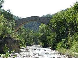
Bridge of Queen Jeanne | ||
| ||
 Entrepierres | ||
|
Location within Provence-A.-C.d'A. region  Entrepierres | ||
| Coordinates: 44°13′08″N 6°00′08″E / 44.2189°N 6.0022°ECoordinates: 44°13′08″N 6°00′08″E / 44.2189°N 6.0022°E | ||
| Country | France | |
| Region | Provence-Alpes-Côte d'Azur | |
| Department | Alpes-de-Haute-Provence | |
| Arrondissement | Forcalquier | |
| Canton | Sisteron | |
| Intercommunality | Sisteron | |
| Government | ||
| • Mayor (2008–2014) | Michel Maillard | |
| Area1 | 47.79 km2 (18.45 sq mi) | |
| Population (2008)2 | 389 | |
| • Density | 8.1/km2 (21/sq mi) | |
| Time zone | CET (UTC+1) | |
| • Summer (DST) | CEST (UTC+2) | |
| INSEE/Postal code | 04075 / 04200 | |
| Elevation |
455–1,444 m (1,493–4,738 ft) (avg. 600 m or 2,000 ft) | |
|
1 French Land Register data, which excludes lakes, ponds, glaciers > 1 km² (0.386 sq mi or 247 acres) and river estuaries. 2 Population without double counting: residents of multiple communes (e.g., students and military personnel) only counted once. | ||

Entrepierres is a commune in the Alpes-de-Haute-Provence department in southeastern France.
Population
| Historical population | ||
|---|---|---|
| Year | Pop. | ±% |
| 1765 | 372 | — |
| 1793 | 421 | +13.2% |
| 1800 | 407 | −3.3% |
| 1806 | 413 | +1.5% |
| 1821 | 383 | −7.3% |
| 1831 | 473 | +23.5% |
| 1836 | 447 | −5.5% |
| 1841 | 432 | −3.4% |
| 1846 | 474 | +9.7% |
| 1851 | 452 | −4.6% |
| 1856 | 439 | −2.9% |
| 1861 | 414 | −5.7% |
| 1866 | 422 | +1.9% |
| 1872 | 397 | −5.9% |
| 1876 | 367 | −7.6% |
| 1881 | 373 | +1.6% |
| 1886 | 346 | −7.2% |
| 1891 | 352 | +1.7% |
| 1896 | 344 | −2.3% |
| 1901 | 302 | −12.2% |
| 1906 | 307 | +1.7% |
| 1911 | 280 | −8.8% |
| 1921 | 218 | −22.1% |
| 1926 | 218 | +0.0% |
| 1931 | 177 | −18.8% |
| 1936 | 157 | −11.3% |
| 1946 | 157 | +0.0% |
| 1954 | 136 | −13.4% |
| 1962 | 106 | −22.1% |
| 1968 | 80 | −24.5% |
| 1975 | 136 | +70.0% |
| 1982 | 163 | +19.9% |
| 1990 | 205 | +25.8% |
| 1999 | 312 | +52.2% |
| 2008 | 389 | +24.7% |
See also
- Communes of the Alpes-de-Haute-Provence department
- http://entrepierres.net/wiki/Accueil a wiki (mostly French) about Entrepierres
References
| Wikimedia Commons has media related to Entrepierres. |
This article is issued from Wikipedia - version of the 11/7/2013. The text is available under the Creative Commons Attribution/Share Alike but additional terms may apply for the media files.