Redortiers
| Redortiers | |
|---|---|
|
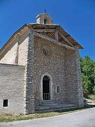
The church of Saint-Jean-Baptiste, in Redortiers | |
 Redortiers | |
|
Location within Provence-A.-C.d'A. region  Redortiers | |
| Coordinates: 44°06′19″N 5°37′08″E / 44.1053°N 5.6189°ECoordinates: 44°06′19″N 5°37′08″E / 44.1053°N 5.6189°E | |
| Country | France |
| Region | Provence-Alpes-Côte d'Azur |
| Department | Alpes-de-Haute-Provence |
| Arrondissement | Forcalquier |
| Canton | Banon |
| Intercommunality | Pays de Banon |
| Government | |
| • Mayor (2008–2014) | Gérard Burcheri |
| Area1 | 45.77 km2 (17.67 sq mi) |
| Population (2008)2 | 86 |
| • Density | 1.9/km2 (4.9/sq mi) |
| Time zone | CET (UTC+1) |
| • Summer (DST) | CEST (UTC+2) |
| INSEE/Postal code | 04159 / 04150 |
| Elevation |
810–1,430 m (2,660–4,690 ft) (avg. 950 m or 3,120 ft) |
|
1 French Land Register data, which excludes lakes, ponds, glaciers > 1 km² (0.386 sq mi or 247 acres) and river estuaries. 2 Population without double counting: residents of multiple communes (e.g., students and military personnel) only counted once. | |
Redortiers is a commune in the Alpes-de-Haute-Provence department in southeastern France.
Population
| Historical population | ||
|---|---|---|
| Year | Pop. | ±% |
| 1793 | 503 | — |
| 1800 | 443 | −11.9% |
| 1806 | 514 | +16.0% |
| 1821 | 485 | −5.6% |
| 1831 | 519 | +7.0% |
| 1836 | 517 | −0.4% |
| 1841 | 500 | −3.3% |
| 1846 | 453 | −9.4% |
| 1851 | 519 | +14.6% |
| 1856 | 465 | −10.4% |
| 1861 | 412 | −11.4% |
| 1866 | 380 | −7.8% |
| 1872 | 364 | −4.2% |
| 1876 | 321 | −11.8% |
| 1881 | 291 | −9.3% |
| 1886 | 282 | −3.1% |
| 1891 | 251 | −11.0% |
| 1896 | 231 | −8.0% |
| 1901 | 221 | −4.3% |
| 1906 | 204 | −7.7% |
| 1911 | 214 | +4.9% |
| 1921 | 150 | −29.9% |
| 1926 | 124 | −17.3% |
| 1931 | 124 | +0.0% |
| 1936 | 136 | +9.7% |
| 1946 | 120 | −11.8% |
| 1954 | 86 | −28.3% |
| 1962 | 104 | +20.9% |
| 1968 | 101 | −2.9% |
| 1975 | 85 | −15.8% |
| 1982 | 73 | −14.1% |
| 1990 | 71 | −2.7% |
| 1999 | 68 | −4.2% |
| 2008 | 86 | +26.5% |
See also
References
| Wikimedia Commons has media related to Redortiers. |
This article is issued from Wikipedia - version of the 2/11/2016. The text is available under the Creative Commons Attribution/Share Alike but additional terms may apply for the media files.