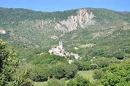
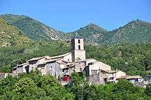
Barras, Alpes-de-Haute-Provence
| Barras | ||
|---|---|---|
|
Barras and the Ruth Summit | ||
| ||
| Motto: "The bravery of Barras" | ||
 Barras | ||
|
Location within Provence-A.-C.d'A. region  Barras | ||
| Coordinates: 44°06′20″N 6°06′50″E / 44.1056°N 6.1139°ECoordinates: 44°06′20″N 6°06′50″E / 44.1056°N 6.1139°E | ||
| Country | France | |
| Region | Provence-Alpes-Côte d'Azur | |
| Department | Alpes-de-Haute-Provence | |
| Arrondissement | Digne-les-Bains | |
| Canton | Digne-les-Bains-Ouest | |
| Intercommunality | Duyes et Bléone | |
| Government | ||
| • Mayor (2008–2014) | Rémy Gravière | |
| Area1 | 20.8 km2 (8.0 sq mi) | |
| Population (2010)2 | 158 | |
| • Density | 7.6/km2 (20/sq mi) | |
| Time zone | CET (UTC+1) | |
| • Summer (DST) | CEST (UTC+2) | |
| INSEE/Postal code | 04021 / 04380 | |
| Elevation |
533–1,298 m (1,749–4,259 ft) (avg. 625 m or 2,051 ft) | |
|
1 French Land Register data, which excludes lakes, ponds, glaciers > 1 km² (0.386 sq mi or 247 acres) and river estuaries. 2 Population without double counting: residents of multiple communes (e.g., students and military personnel) only counted once. | ||
Barras is a French commune in the Alpes-de-Haute-Provence department in the Provence-Alpes-Côte d'Azur region of south-eastern France.[1]
The inhabitants of the commune are known as Barrasiens or Barrasiennes.[2]
Geography
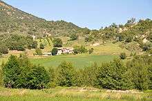
Barras is located some 6 km west of Digne-les-Bains and 14 km south-east of Sisteron. The highest point in the commune is the summit of Ruth (1298m). The sole access to the commune is the D17 road which branches from Route nationale N85 at Mallemoisson and goes north through the commune and the village and continues north to jooin the D3 near Thoard. Apart from the village there are the hamlets of Les Bourguignons and Les Beauduns. The commune is mostly farmland on a fairly rugged landscape.[3][4]
Les Duyes stream forms the eastern border of the commune as it flows south to join the Bléone west of Les Grillons. The Ravin de Vaunaves forms most of the north-eastern border as it flows south-east to join Les Duyes. The Ravin de Fulgon and the Ravin de Rostan rise in the west of the commune and flow east joining before flowing into Les Duyes. The Ravin de Barbarine forms part of the western border of the commune as it flows south to join Les Duyes in the south-eastern corner of the commune.[3][4]
Mapping
A list of online mapping systems can be displayed by clicking on the coordinates (latitude and longitude) in the top right hand corner of this article.
Neighbouring communes and villages
 |
Sourribes | Thoard | | |
| Volonne | |
Champtercier | ||
| ||||
| | ||||
| Mirabeau | Mallemoisson | Aiglun |
Natural and technological risks
None of the 200 communes in the department is in a no seismic risk zone. The Canton of Digne-les-Bains-Ouest to which Barras belongs is in area 1b (low risk) according to the deterministic classification of 1991 and based on its seismic history and in zone 4 (medium risk) according to the probabilistic classification EC8 of 2011. Barras also faces three other natural hazards:[5]
- Forest fire,
- Flooding (in the Duyes valley)
- Landslide: the commune's main concern with an average to high hazard
Barras is not exposed to any risk of technological origin identified by the prefecture.[5]
There is no plan for prevention of foreseeable natural risks (PPR) for the commune and there is no DICRIM.[5]
The commune was the subject of two natural disaster orders in 1994 for floods and mudslides (one order for the winter 1993-1994 and one for autumn).
Toponymy
The locality appears for the first time in texts in 1202 (Barracio). According to Charles Rostaing it is from an oronymic (meaning mountain) root *BAR. According to Ernest Negro it comes from the Gallic barro with the augmentative suffix -as.[6][7]
The toponym La Garde, above Tournefort, may refer to a fortified settlement of the 9th - 10th century[8] and the name Bourguignons refers to the name of the people (Burgundians).[9]
History
In Ancient times, the Bodiontici populated the Bléone valley and its tributaries as well as the Gauls who lived in the current commune of Barras. The Bodiontici were defeated by Augustus at the same time as the other peoples present on the Tropaeum Alpium (before 14 BC.). Barras was attached to the province of Alpes-Maritimes at the time of its creation.[10] An ancient settlement has been found at Saint-Pierre and Chapelier south of the village. The priory of Ganagobie Abbey existed in the 11th century.[8]
In 1070 a person named Féraud donated the fiefdom of Beaucouse (now in the commune of Thoard) to the Abbey of Saint-Victor of Marseille. Most of the territory of Barras was part of this fief so Barras had the Abbey Saint-Victor as lord. At that time there was a large estate (villa) in Saint Domnin where the abbey installed a priory which passed to the Bishop of Gap in the 14th century.[8]
The medieval community in Barras was characterized by scattered settlements. It had 37 fires in 1315. It was heavily depopulated by the crises of the 14th century (the Black Death and the Hundred Years War) and the population was completely eliminated in 1471.[11] The smaller fief of Barras belonged to the counts of Provence until 1297 when Charles II of Naples gave it to a noble family which took the name of the fief (the Barras family).[12] This family lasted until the 19th century and provided many officers such as Jean-Antoine Barras de la Penne (1650-1730) and Jacques Melchior Barras de Saint-Laurent (1719 to 1793).
The community of Tournefort was larger than that of Barras in the Middle Ages: it had 48 fires in 1315 but it was also heavily depopulated by the crises of the 14th century and declared uninhabited in 1400[8] then annexed by Barras in the 15th century.[11] At the same time soldiers seized the castle of Tournefort and threatened the region through their raids and looting. After the successful siege of the castle of Briançonnet (during the same uprising), the army from Sisteron laid siege to Tournefort castle in 1393 and expelled the brigands.[8]
The church was part of the Abbey of Chardavon (currently in the commune of Saint-Geniez) and the Abbey received the revenues attached to this church.[11]
The Patriotic Society of Barras was created in 1791:[13] it was one of the first in the Lower Alps, probably due to the fact that the parish priest, Jean Gaspard Gassend, was deputy to the States General. It corresponded at that time both with the Jacobin Club and the Feuillants Club.[13]
Barras appears as Les Barras on the 1750 Cassini Map[14] and the same on the 1790 version.[15]
The Coup d'état of 2 December 1851 committed by Louis-Napoleon Bonaparte against the French Second Republic provoked an armed uprising in the Lower Alps in defence of the Constitution. After the failure of the uprising harsh repression continued on those who stood up to defend the Republic: 5 inhabitants of Barras were brought before the Joint Committee.[16]
As with many communes in the department, Barras had a school well before the Jules Ferry laws: in 1863 the school already provided a primary education for boys. By contrast no instruction was given to girls: neither the Falloux Laws (1851), which required the opening of a girls' school in communes with more than 800 inhabitants, nor the first Duruy Law (1867), which lowered the threshold to 500 inhabitants, concerned Barras. The second Duruy Act (1877) allowed it, thanks to government subsidies, to build a new school[17] but it was only after the Ferry laws that the village girls were enrolled.[17]
Until the middle of the 20th century vines were cultivated in Barras. The wine product was of poor quality and was intended for local consumption. This culture is now abandoned. Similarly, olive trees, grown on small areas in the 19th century up to an altitude of 600 metres and exceptionally up to 700 metres, is now gone.[18]
Heraldry
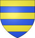 |
Blazon: Barry of 6 Or and Azure. |
Administration
| From | To | Name | Party | Position |
|---|---|---|---|---|
| 1945 | 1947 | Danton Legay[20] | Former French Resistance SE | |
| 2001 | 2008 | Bertin Jassend | ||
| 2008 | 2020[21] | Rémy Gravière |
(Not all data is known)
Education
The commune has a primary school.[22]
Demography
In 2010 the commune had 158 inhabitants. The evolution of the number of inhabitants is known from the population censuses conducted in the commune since 1793. From the 21st century, a census of communes with fewer than 10,000 inhabitants is held every five years, unlike larger communes that have a sample survey every year.[Note 1]
| 1793 | 1800 | 1806 | 1821 | 1831 | 1836 | 1841 | 1846 | 1851 |
|---|---|---|---|---|---|---|---|---|
| 326 | - | 285 | 244 | 282 | 307 | 273 | 277 | 299 |
| 1856 | 1861 | 1866 | 1872 | 1876 | 1881 | 1886 | 1891 | 1896 |
|---|---|---|---|---|---|---|---|---|
| 291 | 282 | 258 | 269 | 261 | 267 | 223 | 202 | 186 |
| 1901 | 1906 | 1911 | 1921 | 1926 | 1931 | 1936 | 1946 | 1954 |
|---|---|---|---|---|---|---|---|---|
| 167 | 165 | 162 | 155 | 153 | 135 | 123 | 130 | 100 |
| 1962 | 1968 | 1975 | 1982 | 1990 | 1999 | 2006 | 2010 | - |
|---|---|---|---|---|---|---|---|---|
| 113 | 109 | 93 | 84 | 111 | 121 | 158 | - |
Sources : Ldh/EHESS/Cassini until 1962, INSEE database from 1968 (population without double counting and municipal population from 2006)
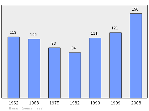
The demographic history of Barras, after the decimation in the 14th and 15th centuries and the gradual growth until the beginning of the 19th century, is marked by a period of "slack" where the population remained relatively stable at a high level. This period lasted from 1806 to 1861. The rural exodus then caused a movement of long-term population decline. In 1926 the town had lost over half of its population compared to the historical peak of 1836. The downward movement was interrupted in the 1980s. Since then the population of Barras overtook the threshold of 150 inhabitants equivalent to half that of 1836.[23]
Economy
General overview
In 2009 the active population was 66 people including 3 unemployed (11 at the end of 2011). These workers are mostly employees (76%) and mainly work outside the commune (77%). Most of the communal workers are in agriculture, with 13 establishments and 5 salaried jobs. Industry and construction supplies 20% of salaried jobs in the commune.[23]
Agriculture
At the end of 2010 the primary sector (agriculture, forestry) had thirteen active establishments within the meaning of Insee and five salaried jobs.[23]
According to Agreste survey by the Ministry of Agriculture the number of farms increased slightly in the 2000s, going from ten to eleven, mainly sheep and cattle farms. From 1988 to 2000, the utilised agricultural area (UAA) increased sharply from 311 hectares to 1289 while the number of farms fell from 14 to 11. The UAA declined slightly during the past decade, but remains at a high level at 1215 hectares.[24]
The commune is included in the scope of the Appellation d'origine contrôlée Huile d'olive de Provence AOC (Olive oil of Provence AOC).
Industry
At the end of 2010 the secondary sector (industry and construction) had a single establishment employing 18 (17 in 2012) employees: the Duyes Valley Workshop, which is a Social economy enterprise specializing in packaging.[25]
Service activities
At the end of 2010 the tertiary sector (trade, services) had 5 establishments with no employees, to which can be added four administrative institutions employing 3 people.
According to the Departmental Observatory of Tourism, the tourist function is of secondary importance to the town with less than one tourist received per capita with no facilities at all in the commune.[26]
There are just 5 Second homes in the commune.
Culture and heritage
Religious heritage
The Church of Saint Nicolas (17th century) has a bell tower with arches and two windows above the church. The nave rises to the roof. The door indicates a date in the 17th century. Its Retable is decorated with a common theme of the Donation pof the Rosary.[27]
The Church contains a Baptismal font (19th century)![]() that is registered as an historical object.[28]
that is registered as an historical object.[28]
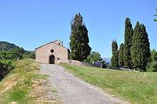
The commune also has three chapels in ruins:
- Saint Louis Chapel from 1732 in the village with a small steeple, converted into a henhouse;[29]
- Saint Peter's Cemetery Chapel, Romanesque, is the old parish church;[8]
- Saint Valentine's Chapel on a hill overlooking the village of Mirabeau, existed in the 17th century, but was in ruins at the end of the 19th century.[8]
Notable people linked to the commune
- Jean Gaspard Gassend, deputy in the States General of 1789
- Paul Barras (1755-1829), revolutionary, was Viscount of Barras
See also
Bibliography
- Raymond Collier, Haute-Provence, monumental and artistic, Digne, Louis Jean Printing,1986, 559 p.
- Under the direction of Édouard Baratier, Georges Duby, and Ernest Hildesheimer, Historical Atlas, Provence, Venaissin County, Principality of Orange, County of Nice, Principality of Monaco, Paris, Librairie Armand Colin, 1969 (Record BNF No. FRBNF35450017h)
Notes and references
Notes
- ↑ At the beginning of the 21st century, the methods of identification have been modified by Law No. 2002-276 of 27 February 2002, the so-called "law of local democracy" and in particular Title V "census operations" allows, after a transitional period running from 2004 to 2008, the annual publication of the legal population of the different French administrative districts. For communes with a population greater than 10,000 inhabitants, a sample survey is conducted annually and the entire territory of these communes is taken into account at the end of the period of five years. The first "legal population" after 1999 under this new law came into force on 1 January 2009 and was based on the census of 2006.
References
- ↑ Barras on Lion1906
- ↑ Inhabitants of Alpes-de-Haute-Provence (French)
- 1 2 3 Barras on Google Maps
- 1 2 Barras on the Géoportail from National Geographic Institute (IGN) website (French)
- 1 2 3 Ministry of Ecology, sustainable development, transport, and lodgings, Communal Notice Barras on the Gaspar database, consulted on 16 November 2015.
- ↑ Albert Dauzat and Charles Rostaing, Etymological Dictionary of place names in France, Larousse, Paris, 1963 (French)
- ↑ Ernest Nègre, General Toponymy of France, Librairie Droz, 1990, Vol I, 708 pages, p. 130, ISBN 2-60002-883-8 (French).
- 1 2 3 4 5 6 7 Daniel Thiery, Barras, On the origins of rural Chuches and Chapels of Alpes-de-Haute-Provence, published 13 December 2010, online 14 December 2010, consulted on 2 July 2012. (French)
- ↑ Bénédicte Fénié, Jean-Jacques Fénié, Provençal Toponymy, Éditions Sud-Ouest, 2002 (reprint), ISBN 978-2-87901-442-5, p. 75 (French)
- ↑ Brigitte Beaujard, The towns of Southern Gaul from the 3rd to the 7th centuries, Gallia, 63, 2006, CNRS éditions, p. 22. (French)
- 1 2 3 Under the direction of Édouard Baratier, Georges Duby, and Ernest Hildesheimer, Historical Atlas. Provence, Comtat Venaissin, Principality of Orange, County of Nice, Principality of Monaco, Paris, Librairie Armand Colin, 1969 (notice BnF no FRBNF35450017h), p. 163. and Map 72 (French)
- ↑ "Donation made by Charles II, Count of Ceste Province in favour of William of Barras as a reward for signal services rendered by him: the places, lands, and lordships Barras and its valley, the castles and lands of Thoard and Mellan, Auribeau, Castellar, and Saint Esteve with all their rights and appurtenances on 24 February 1294", Evidence of nobility produced by the Barras family in 1667
- 1 2 Patrice Alphand, "The Popular Societies", The Revolution in the Lower Alps, Annales de Haute-Provence, bulletin of the Scientific and Literary Society of Alpes-de-Haute-Provence, No. 307, 1st trimester 1989, 108th year, p. 11. and 301 (French)
- ↑ Les Barras on the 1750 Cassini Map
- ↑ Les Barras on the 1790 Cassini Map
- ↑ Henri Joannet, Jean-Pierre Pinatel, Arrests-Condemnations, 1851-Pour mémoire, Les Mées: Les Amis des Mées, 2001, p. 71. (French)
- 1 2 Jean-Christophe Labadie (director), The School Houses, Digne-les-Bains, Departmental Archives of Alpes-de-Haute-Provence, 2013, ISBN 978-2-86-004-015-0, p. 9-18. (French)
- ↑ André de Réparaz, Lost Lands, Constant Lands, Conquered Lands: vines and olives in Haute-Provence XIXe-XXIe siècles », Méditerranée, 109 | 2007, p. 56 to 59 (French)
- ↑ List of Mayors of France (French)
- ↑ Sébastien Thébault and Thérèse Dumont, The Liberation, Basses-Alpes 39-45, published 31 March 2014, consulted 2 April 2014. (French)
- ↑ Prefecture of Alpes-de-Haute-Provence, List of Mayors, 2014, consulted 19 November 2015 (French)
- ↑ Schools in Barras (French)
- 1 2 3 Insee, Local Dossier - Commune: Barras (04021)
- ↑ Ministry of Agriculture, "Technical/Economic Orientation of Farming", Agricultural Census of 2010 and 2000, Download (4 mb) (French)
- ↑ Chamber of Commerce and Industry of Alpes-de-Haute-Provence, Workshop of the Duyes Valley, consulted on 20 September 2012 (French)
- ↑ Departmental Observatory of Tourism, Atlas of Tourist Accommodation, 2015 p. 40 (French)
- ↑ Raymond Collier, Haute-Provence Monumental and Artistic, Digne, Imprimerie Louis Jean,? 1986, 559 p., p 481
- ↑ Ministry of Culture, Palissy PM04003220 Baptismal font (French)
- ↑ Raymond Collier, Haute-Provence Monumental and Artistic, Digne, Imprimerie Louis Jean,? 1986, 559 p., p 231
| Wikimedia Commons has media related to Barras, Alpes-de-Haute-Provence. |