Saint-Jeannet, Alpes-de-Haute-Provence
| Saint-Jeannet | ||
|---|---|---|
|
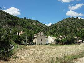
The hamlet of Saint-Jeannet | ||
| ||
 Saint-Jeannet | ||
|
Location within Provence-A.-C.d'A. region  Saint-Jeannet | ||
| Coordinates: 43°57′12″N 6°07′27″E / 43.9533°N 6.1242°ECoordinates: 43°57′12″N 6°07′27″E / 43.9533°N 6.1242°E | ||
| Country | France | |
| Region | Provence-Alpes-Côte d'Azur | |
| Department | Alpes-de-Haute-Provence | |
| Arrondissement | Digne-les-Bains | |
| Canton | Mézel | |
| Intercommunality | Asse | |
| Government | ||
| • Mayor (2001–2008) | Jacquelyn Pierrisnard | |
| Area1 | 21.14 km2 (8.16 sq mi) | |
| Population (2008)2 | 53 | |
| • Density | 2.5/km2 (6.5/sq mi) | |
| Time zone | CET (UTC+1) | |
| • Summer (DST) | CEST (UTC+2) | |
| INSEE/Postal code | 04181 / 04270 | |
| Elevation |
567–971 m (1,860–3,186 ft) (avg. 583 m or 1,913 ft) | |
|
1 French Land Register data, which excludes lakes, ponds, glaciers > 1 km² (0.386 sq mi or 247 acres) and river estuaries. 2 Population without double counting: residents of multiple communes (e.g., students and military personnel) only counted once. | ||

Saint-Jeannet is a commune in the Alpes-de-Haute-Provence department in southeastern France.
Population
| Historical population | ||
|---|---|---|
| Year | Pop. | ±% |
| 1765 | 331 | — |
| 1793 | 374 | +13.0% |
| 1800 | 280 | −25.1% |
| 1806 | 290 | +3.6% |
| 1821 | 324 | +11.7% |
| 1831 | 316 | −2.5% |
| 1836 | 329 | +4.1% |
| 1841 | 303 | −7.9% |
| 1846 | 309 | +2.0% |
| 1851 | 315 | +1.9% |
| 1856 | 327 | +3.8% |
| 1861 | 296 | −9.5% |
| 1866 | 274 | −7.4% |
| 1872 | 268 | −2.2% |
| 1876 | 242 | −9.7% |
| 1881 | 264 | +9.1% |
| 1886 | 251 | −4.9% |
| 1891 | 238 | −5.2% |
| 1896 | 201 | −15.5% |
| 1901 | 225 | +11.9% |
| 1906 | 183 | −18.7% |
| 1911 | 162 | −11.5% |
| 1921 | 112 | −30.9% |
| 1926 | 116 | +3.6% |
| 1931 | 101 | −12.9% |
| 1936 | 73 | −27.7% |
| 1946 | 76 | +4.1% |
| 1954 | 60 | −21.1% |
| 1962 | 53 | −11.7% |
| 1968 | 42 | −20.8% |
| 1975 | 52 | +23.8% |
| 1982 | 43 | −17.3% |
| 1990 | 47 | +9.3% |
| 1999 | 38 | −19.1% |
| 2008 | 53 | +39.5% |
See also
References
| Wikimedia Commons has media related to Saint-Jeannet, Alpes-de-Haute-Provence. |
This article is issued from Wikipedia - version of the 10/8/2016. The text is available under the Creative Commons Attribution/Share Alike but additional terms may apply for the media files.