Valernes
| Valernes | ||
|---|---|---|
|
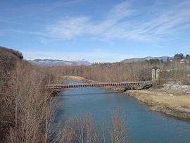
The Fombeton bridge, in Valernes | ||
| ||
 Valernes | ||
|
Location within Provence-A.-C.d'A. region  Valernes | ||
| Coordinates: 44°15′47″N 5°57′32″E / 44.2631°N 5.9589°ECoordinates: 44°15′47″N 5°57′32″E / 44.2631°N 5.9589°E | ||
| Country | France | |
| Region | Provence-Alpes-Côte d'Azur | |
| Department | Alpes-de-Haute-Provence | |
| Arrondissement | Forcalquier | |
| Canton | La Motte-du-Caire | |
| Government | ||
| • Mayor (2008–2014) | Gérard Euloge | |
| Area1 | 28.49 km2 (11.00 sq mi) | |
| Population (2008)2 | 241 | |
| • Density | 8.5/km2 (22/sq mi) | |
| Time zone | CET (UTC+1) | |
| • Summer (DST) | CEST (UTC+2) | |
| INSEE/Postal code | 04231 / 04200 | |
| Elevation |
460–1,357 m (1,509–4,452 ft) (avg. 625 m or 2,051 ft) | |
|
1 French Land Register data, which excludes lakes, ponds, glaciers > 1 km² (0.386 sq mi or 247 acres) and river estuaries. 2 Population without double counting: residents of multiple communes (e.g., students and military personnel) only counted once. | ||

Valernes is a commune in the Alpes-de-Haute-Provence department in southeastern France.
Population
| Historical population | ||
|---|---|---|
| Year | Pop. | ±% |
| 1765 | 541 | — |
| 1793 | 686 | +26.8% |
| 1800 | 646 | −5.8% |
| 1806 | 658 | +1.9% |
| 1821 | 643 | −2.3% |
| 1831 | 687 | +6.8% |
| 1836 | 701 | +2.0% |
| 1841 | 702 | +0.1% |
| 1846 | 711 | +1.3% |
| 1851 | 681 | −4.2% |
| 1856 | 707 | +3.8% |
| 1861 | 662 | −6.4% |
| 1866 | 591 | −10.7% |
| 1872 | 623 | +5.4% |
| 1876 | 590 | −5.3% |
| 1881 | 583 | −1.2% |
| 1886 | 572 | −1.9% |
| 1891 | 488 | −14.7% |
| 1896 | 497 | +1.8% |
| 1901 | 437 | −12.1% |
| 1906 | 431 | −1.4% |
| 1911 | 412 | −4.4% |
| 1921 | 316 | −23.3% |
| 1926 | 300 | −5.1% |
| 1931 | 285 | −5.0% |
| 1936 | 252 | −11.6% |
| 1946 | 229 | −9.1% |
| 1954 | 218 | −4.8% |
| 1962 | 191 | −12.4% |
| 1968 | 174 | −8.9% |
| 1975 | 142 | −18.4% |
| 1982 | 178 | +25.4% |
| 1990 | 222 | +24.7% |
| 1999 | 231 | +4.1% |
| 2008 | 241 | +4.3% |
See also
References
| Wikimedia Commons has media related to Valernes. |
This article is issued from Wikipedia - version of the 3/15/2016. The text is available under the Creative Commons Attribution/Share Alike but additional terms may apply for the media files.