Saint-Pons, Alpes-de-Haute-Provence
| Saint-Pons | |
|---|---|
|
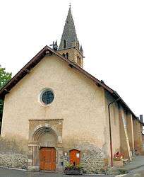
The church in Saint-Pons | |
 Saint-Pons | |
|
Location within Provence-A.-C.d'A. region  Saint-Pons | |
| Coordinates: 44°23′35″N 6°37′43″E / 44.3931°N 6.6286°ECoordinates: 44°23′35″N 6°37′43″E / 44.3931°N 6.6286°E | |
| Country | France |
| Region | Provence-Alpes-Côte d'Azur |
| Department | Alpes-de-Haute-Provence |
| Arrondissement | Barcelonnette |
| Canton | Barcelonnette |
| Intercommunality | Vallée de l'Ubaye |
| Government | |
| • Mayor (2008–2014) | Michel Nicolao |
| Area1 | 32.06 km2 (12.38 sq mi) |
| Population (2008)2 | 720 |
| • Density | 22/km2 (58/sq mi) |
| Time zone | CET (UTC+1) |
| • Summer (DST) | CEST (UTC+2) |
| INSEE/Postal code | 04195 / 04400 |
| Elevation |
1,097–2,879 m (3,599–9,446 ft) (avg. 1,145 m or 3,757 ft) |
|
1 French Land Register data, which excludes lakes, ponds, glaciers > 1 km² (0.386 sq mi or 247 acres) and river estuaries. 2 Population without double counting: residents of multiple communes (e.g., students and military personnel) only counted once. | |
Saint-Pons is a commune in the Alpes-de-Haute-Provence department in southeastern France.
Population
| Historical population | ||
|---|---|---|
| Year | Pop. | ±% |
| 1793 | 632 | — |
| 1800 | 658 | +4.1% |
| 1806 | 593 | −9.9% |
| 1821 | 698 | +17.7% |
| 1831 | 658 | −5.7% |
| 1836 | 682 | +3.6% |
| 1841 | 616 | −9.7% |
| 1846 | 661 | +7.3% |
| 1851 | 610 | −7.7% |
| 1856 | 536 | −12.1% |
| 1861 | 513 | −4.3% |
| 1866 | 574 | +11.9% |
| 1872 | 544 | −5.2% |
| 1876 | 482 | −11.4% |
| 1881 | 467 | −3.1% |
| 1886 | 496 | +6.2% |
| 1891 | 430 | −13.3% |
| 1896 | 348 | −19.1% |
| 1901 | 316 | −9.2% |
| 1906 | 320 | +1.3% |
| 1911 | 323 | +0.9% |
| 1921 | 277 | −14.2% |
| 1926 | 299 | +7.9% |
| 1931 | 244 | −18.4% |
| 1936 | 224 | −8.2% |
| 1946 | 225 | +0.4% |
| 1954 | 184 | −18.2% |
| 1962 | 193 | +4.9% |
| 1968 | 178 | −7.8% |
| 1975 | 350 | +96.6% |
| 1982 | 401 | +14.6% |
| 1990 | 507 | +26.4% |
| 1999 | 641 | +26.4% |
| 2008 | 720 | +12.3% |
See also
References
| Wikimedia Commons has media related to Saint-Pons, Alpes-de-Haute-Provence. |
This article is issued from Wikipedia - version of the 10/8/2016. The text is available under the Creative Commons Attribution/Share Alike but additional terms may apply for the media files.