Le Vernet, Alpes-de-Haute-Provence
| Le Vernet | ||
|---|---|---|
|
The church of Sainte-Marthe, in Le Vernet | ||
| ||
 Le Vernet | ||
|
Location within Provence-A.-C.d'A. region  Le Vernet | ||
| Coordinates: 44°16′37″N 6°23′29″E / 44.2769°N 6.3914°ECoordinates: 44°16′37″N 6°23′29″E / 44.2769°N 6.3914°E | ||
| Country | France | |
| Region | Provence-Alpes-Côte d'Azur | |
| Department | Alpes-de-Haute-Provence | |
| Arrondissement | Digne-les-Bains | |
| Canton | Seyne | |
| Intercommunality | Pays de Seyne | |
| Government | ||
| • Mayor (2008–2014) | François Balique | |
| Area1 | 23.05 km2 (8.90 sq mi) | |
| Population (2008)2 | 126 | |
| • Density | 5.5/km2 (14/sq mi) | |
| Time zone | CET (UTC+1) | |
| • Summer (DST) | CEST (UTC+2) | |
| INSEE/Postal code | 04237 / 04140 | |
| Elevation |
1,153–2,642 m (3,783–8,668 ft) (avg. 1,200 m or 3,900 ft) | |
|
1 French Land Register data, which excludes lakes, ponds, glaciers > 1 km² (0.386 sq mi or 247 acres) and river estuaries. 2 Population without double counting: residents of multiple communes (e.g., students and military personnel) only counted once. | ||

Le Vernet is a commune in the Alpes-de-Haute-Provence department, and in the region of Provence-Alpes-Côte d'Azur, in southeastern France.
The name of its inhabitants is Vernetois[1] or Vernetiers.
Geography
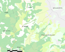
The village of Le Vernet is located in the Bès Valley at 1,200 metres (3,900 ft) altitude.[2] Its population does not exceed 100 permanent residents, but it is often more than doubled each summer and winter, when the municipality becomes the place of departure for sightseeing excursions, particularly in the Blanche Valley, and a place of departure for the nearby ski stations (Grand-Puy, Saint-Jean-Montclar and Chabanon).
The municipality has two main villages, Haut-Vernet, perched high and Bas-Vernet below.
Geology
During the two last major glaciations, the Riss glaciation and the Würm glaciation, a glacier was present in the upper part of the Riou de la Montagne Valley. During the Riss glaciation, a diffluence of the Blanche glacier crossed the Col de Maure and reached approximately to the location of the village of the current Bas-Vernet. The diffluence was reproduced during the Würm period, but did not reach the territory of Vernet.[3]
Relief
The Pic des Têtes, at 2,642 metres (8,668 ft), is located within the territory of the commune, as well as the Col du Labouret, in the Massif des Trois-Évêchés.
Environment
The commune comprises 689 hectares (1,700 acres) of woods and forests.[1]
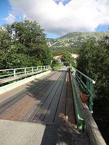
Transport
Natural and technological hazards
None of the 200 communes of the Department is in the zero seismic risk zone. The Canton of Seyne, to which Le Vernet belongs, is in zone 1b (low seismicity) determined by the 1991 classification, based on the historical earthquakes,[4] and in zone 4 (medium risk) according to the probabilistic classification EC8 of 2011.[5] The municipality of Le Vernet is also exposed to four other natural hazards:[5]
- Avalanche
- Forest fire
- Flooding
- Ground movement
The commune of Le Vernet is more exposed to a risk of technological origin, that of transport of dangerous goods by road.[6] The departmentale RD 900 (the former Route nationale 100) can be used for the road transport of dangerous goods.[7]
A predictable natural risk prevention plan (PPR) doesn't exist for the commune[6] and DICRIM does not exist either.[8]
History remembers two earthquakes to have been strongly felt in the town. They exceeded a macro-seismic intensity level V on the MSK scale (sleepers awake, falling objects). The specified intensities are those felt in the town, the intensity can be stronger at the epicentre:[9]
- The earthquake of 22 March 1949 had an intensity level V, and with Le Lauzet at the epicentre[10]
- The earthquake of 31 October 1997 had an intensity level V, and with Prads-Haute-Bléone at the epicentre[11]
Toponymy
According to the Fénie couple, the name of Le Vernet refers to alder.[12]
History
During antiquity, the Bodiontiques (Bodiontici) lived in the Bléone Valley, and were therefore the Gallic people who lived in the current municipality of Vernet. The Bodiontiques, who were defeated by Augustus at the same time as other peoples present on the Tropaeum Alpium (before 14 BC), are attached to the province of Alpes Maritimae at its inception.[13]
The town appears for the first time in charters in the 11th century.[14] The Priory of Saint-Clément was under the Abbey of Saint-Victor in Marseille, via the Priory of Chaudol (now in La Javie).[15] The priory decided the questes and the taille, the lord decided the cavalcade and the albergue.[15] The Comte of Provence Ramon Berenguer IV granted to the community, who reported to the Bailli of Seyne, a consulate in the 13th century.[14]
In the Middle Ages, the great road of Digne to Seyne passed, descending from the Col du Labouret, by Haut-Vernet, without following the Bès Valley.[15]
In 1602, the trial exploitation of a vein of copper was cut short, the deposit actually being very poor. As early as 1604, the owners couldn't pay the workers, some were sent to Villevieille and Verdaches. These mines were given a new concession in 1614, without which their operation would never have restarted.[16]
During the French Revolution, the town had a patriotic society, created after the end of 1792.[17]
As with many communes of the Department, Le Vernet acquired schools well before the Jules Ferry laws: In 1863, it had one each at Haut-Vernet and Bas-Vernet, which provide a primary education for boys.[18] While the Falloux Laws of 1851 required the opening of a girls school for communes with more than 800 inhabitants,[19] and the first Duruy Law of 1867 lowered the threshold to 500 inhabitants, Le Vernet nevertheless opened a school for girls, ahead of the laws.[20] The commune took advantage of subsidies from the second Duruy Law in 1877 to build a new school at Haut-Vernet.[21]
On 24 March 2015, Germanwings Flight 9525, an Airbus A320 flying from Barcelona to Düsseldorf, crashed in the mountains of the neighboring commune of Prads-Haute-Bléone, near to the border with Le Vernet.
Politics and administration
| Start | End | Name | Party | Other details |
|---|---|---|---|---|
| May 1945 | Paul Mathieu[22] | |||
| ... | ||||
| 1977[23] | In progress (as of 21 October 2014) | François Balique[23][24][25][26] | President of the Community of communes |
Population and society
Demography
In 2012, the Vernet had 123 inhabitants. From the 21st century, communes with less than 10,000 inhabitants have a census held every five years (2004, 2009 and 2014, etc. for the Vernet). Since 2004, the other figures are estimates.
| Historical population | |||||||||||||||||||||||||||||||||||||||||||||||||||||||||||||||||||||||||||||||||||||||||||||||||||||||||||||||||||||||||||
|---|---|---|---|---|---|---|---|---|---|---|---|---|---|---|---|---|---|---|---|---|---|---|---|---|---|---|---|---|---|---|---|---|---|---|---|---|---|---|---|---|---|---|---|---|---|---|---|---|---|---|---|---|---|---|---|---|---|---|---|---|---|---|---|---|---|---|---|---|---|---|---|---|---|---|---|---|---|---|---|---|---|---|---|---|---|---|---|---|---|---|---|---|---|---|---|---|---|---|---|---|---|---|---|---|---|---|---|---|---|---|---|---|---|---|---|---|---|---|---|---|---|---|---|
|
|
|
| ||||||||||||||||||||||||||||||||||||||||||||||||||||||||||||||||||||||||||||||||||||||||||||||||||||||||||||||||||||||||
| Population without double counting from 1962 to 1999; municipal population from 2006 Source: Baratier, Georges Duby & Hildesheimer for the Ancien Régime,[14] EHESS,[27] Insee à partir de 1968[28][29][30][31] | |||||||||||||||||||||||||||||||||||||||||||||||||||||||||||||||||||||||||||||||||||||||||||||||||||||||||||||||||||||||||||
The demographic history of Le Vernet, after the depopulation of the 14th and 15th centuries and long movement of growth until the beginning of the 19th century, is marked by a period of 'spread' where the population remains stable at a high level. This period lasts from 1806 to 1846. The rural exodus then caused a rapid decline in population, most importantly a long-term movement. Between 1911 and 1921, the municipality records the loss of more than half of its population (relative to the historic maximum).[32] The downward movement is interrupted only in the 1980s. Since then, the population has doubled.
Education
The town depends on the Academy of Aix-Marseille.[33] It has a primary school, consisting of 9 students.[34]
Religion
The Catholic parish of Le Vernet depends on the Diocese of Digne, Riez and Sisteron.[35]
Local culture and heritage
Sites and monuments
In Bas-Vernet, the parish church of Sainte-Marthe dates from the 19th century.[15]
At Haut-Vernet, the Saint-Martin Church[15] is also from the 19th century.
The chapel of Saint-Pancrace, isolated above Haut-Vernet, is the old parish church. Ruined by the European wars of religion, it was rebuilt, and its roof was repaired again in the 20th century.[15]
- The Oratory of Saint-Roch
Notable people
- Gaspard Laurent Bayle, physician to Napoleon
- Prosper Demontzey has a monument at the Col du Labouret
Heraldry
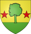 |
The arms of Prads-Haute-Bléone are blazoned : Gold to a tree of vert on a terrace of the same docked two stars of gules.[36] |
See also
- Communes of the Alpes-de-Haute-Provence department
- List of ancient communes in Alpes-de-Haute-Provence
Bibliography
- Collier, Raymond (1986). La Haute-Provence monumentale et artistique [The monumental and artistic Haute-Provence] (in French). Digne: Imprimerie Louis Jean.
- Baratier, Édouard; Duby, Georges; Hildesheimer, Ernest (1969). Atlas historique. Provence, Comtat Venaissin, principauté d’Orange, comté de Nice, principauté de Monaco [Historical Atlas. Comtat Venaissin, Principality of Orange, County of Nice, Provence, Principality of Monaco] (in French). Paris: Librairie Armand Colin. (BnF no. FRBNF35450017h)
References
- 1 2 "Canton de Seyne - Le Trésor des régions". Retrieved 31 March 2015.
- ↑ de La Torre, Michel (1989). Alpes-de-Haute-Provence: le guide complet des 200 communes [Alpes-de-Haute-Provence: The complete guide to the 200 communes] (in French). Paris: Deslogis-Lacoste. ISBN 2-7399-5004-7.
- ↑ Jorda, Maurice; Miramont, Cécile (2008). Les Hautes Terres de Provence : itinérances médiévales [Highlands of Provence: medieval roaming] (in French). Cairo: Association Les hautes terres de Provence ; Saint-Michel-l'Observatoire. p. 33. ISBN 978-2-952756-43-3.
- ↑ "Dossier départemental sur les risques majeurs dans les Alpes-de-Haute-Provence". Préfecture des Alpes-de-Haute-Provence. 2008. p. 39. Archived from the original on 6 September 2012.
- 1 2 "Notice communale". Ministère de l’Écologie, du développement durable, des transports et du logement. Retrieved 31 March 2015.
- 1 2 "Dossier départemental sur les risques majeurs dans les Alpes-de-Haute-Provence". Préfecture des Alpes-de-Haute-Provence. 2008. p. 98. Archived from the original on 6 September 2012.
- ↑ "Dossier départemental sur les risques majeurs dans les Alpes-de-Haute-Provence". Préfecture des Alpes-de-Haute-Provence. 2008. p. 80. Archived from the original on 6 September 2012.
- ↑ "Formulaire de recherche". DICRIM. Archived from the original on 6 September 2012. Retrieved 31 March 2015.
- ↑ "Épicentres de séismes lointains (supérieurs à 40 km) ressentis à Le Vernet". Sisfrance. BRGM. Retrieved 31 March 2015.
- ↑ "fiche 40203". Sisfrance. BRGM. Retrieved 31 March 2015.
- ↑ "fiche 40092". Sisfrance. BRGM. Retrieved 31 March 2015.
- ↑ Fénié, Bénédicte; Fénié, Jean-Jacques (2002). Toponymie provençale [Provencal toponymy] (in French). Éditions Sud-Ouest. p. 99. ISBN 978-2-87901-442-5.
- ↑ Brigitte Beaujard, « Les cités de la Gaule méridionale du IIIe au VIIe s. », Gallia, 63, 2006, CNRS éditions, p. 22
- 1 2 3 Baratier, Edouard; Duby, Georges; Hildesheimer, Ernest (1969). Atlas historique. Provence, Comtat Venaissin, principauté d’Orange, comté de Nice, principauté de Monaco [Historical Atlas. Comtat Venaissin, Principality of Orange, County of Nice, Provence, Principality of Monaco] (in French). Paris: Librairie Armand Colin. p. 206. (BnF no. FRBNF35450017h)
- 1 2 3 4 5 6 "Aux origines des églises et chapelles rurales des Alpes-de-Haute-Provence". Retrieved 31 March 2015.
- ↑ Billioud, Joseph (1958). "Les mines de plomb des Basses-Alpes du XVIe au XIXe siècle" (PDF). 8 (31). Provence historique: 43–45.
- ↑ Alphand, Patrice (1989). ""Les Sociétés populaires" La Révolution dans les Basses-Alpes". Annales de Haute-Provence. 108 (307): 296–298.
- ↑ Labadie, Jean-Christophe (2013). Les Maisons d’école. Digne-les-Bains: Archives départementales des Alpes-de-Haute-Provence. p. 9. ISBN 978-2-86-004-015-0.
- ↑ Labadie, Jean-Christophe (2013). Les Maisons d’école. Digne-les-Bains: Archives départementales des Alpes-de-Haute-Provence. p. 16. ISBN 978-2-86-004-015-0.
- ↑ Labadie, Jean-Christophe (2013). Les Maisons d’école. Digne-les-Bains: Archives départementales des Alpes-de-Haute-Provence. p. 18. ISBN 978-2-86-004-015-0.
- ↑ Labadie, Jean-Christophe (2013). Les Maisons d’école. Digne-les-Bains: Archives départementales des Alpes-de-Haute-Provence. p. 11. ISBN 978-2-86-004-015-0.
- ↑ "La Libération". Basses-Alpes 39-45. Retrieved 2 April 2015.
- 1 2 G. M., « Vers une liste citoyenne unique », La Provence, 14 February 2014, p. 11.
- ↑ "De Sourribes à Volx (liste 8)". Préfecture des Alpes-de-Haute-Provence. Retrieved 2 April 2015.
- ↑ François Balique is one of 500 elected officials who have sponsored the candidacy of François Mitterrand (PS) in the presidential elections of 1988 "liste des citoyens ayant présenté les candidats à l'élection du Président de la République [archive]". Journal officiel de la République française du 12 avril 1988. Conseil constitutionnel: 4792. Retrieved 2 April 2015.
- ↑ "Liste des maires" (PDF). Préfecture des Alpes-de-Haute-Provence. Archived from the original (PDF) on 23 October 2014.
- ↑ "notice communale de Le Vernet". Cassini. EHESS. Retrieved 2 April 2015.
- ↑ "Résultats du recensement de la population - Le Vernet". Insee. Retrieved 1 January 2012.
- ↑ "Recensement de la population au 1er janvier 2004". Insee. Archived from the original on 8 March 2014.
- ↑ "Recensement de la population au 1er janvier 2009". Insee. Retrieved 2 April 2015.
- ↑ "Populations légales 2011 en vigueur le 1er janvier 2014". Insee. Retrieved 2 April 2015.
- ↑ Vidal, Christiane (1971). "Chronologie et rythmes du dépeuplement dans le département des Alpes de Haute- Provence depuis le début du XIX' siècle" [Timeline and rhythms of the depopulation in the Department of Alpes de Haute - Provence since the beginning of the 19th century] (in French). 21 (85). Provence historique: 287.
- ↑ "ac-aix-marseille.fr". Retrieved 2 April 2015.
- ↑ "École primaire publique". Ministère de l'Éducation nationale. Retrieved 2 April 2015.
- ↑ "Le Vernet". catholique.fr. Retrieved 2 April 2015.
- ↑ Louis de Bresc, Armorial des communes de Provence, 1866. Réédition : Marcel Petit CPM, Raphèle-lès-Arles, 1994
External links
| Wikimedia Commons has media related to Le Vernet, Alpes-de-Haute-Provence. |