Méailles
| Méailles | ||
|---|---|---|
|
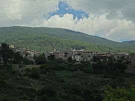
A view of the village of Méailles | ||
| ||
 Méailles | ||
|
Location within Provence-A.-C.d'A. region  Méailles | ||
| Coordinates: 44°01′27″N 6°37′56″E / 44.0242°N 6.6322°ECoordinates: 44°01′27″N 6°37′56″E / 44.0242°N 6.6322°E | ||
| Country | France | |
| Region | Provence-Alpes-Côte d'Azur | |
| Department | Alpes-de-Haute-Provence | |
| Arrondissement | Castellane | |
| Canton | Annot | |
| Intercommunality | Terres de Lumière | |
| Government | ||
| • Mayor (2008–2014) | Viviane Pons-Bertaina | |
| Area1 | 32.74 km2 (12.64 sq mi) | |
| Population (2008)2 | 110 | |
| • Density | 3.4/km2 (8.7/sq mi) | |
| Time zone | CET (UTC+1) | |
| • Summer (DST) | CEST (UTC+2) | |
| INSEE/Postal code | 04115 / 04240 | |
| Elevation |
867–2,183 m (2,844–7,162 ft) (avg. 1,050 m or 3,440 ft) | |
|
1 French Land Register data, which excludes lakes, ponds, glaciers > 1 km² (0.386 sq mi or 247 acres) and river estuaries. 2 Population without double counting: residents of multiple communes (e.g., students and military personnel) only counted once. | ||

Méailles is a commune in the Alpes-de-Haute-Provence department in southeastern France.
Population
| Historical population | ||
|---|---|---|
| Year | Pop. | ±% |
| 1765 | 500 | — |
| 1793 | 593 | +18.6% |
| 1800 | 559 | −5.7% |
| 1806 | 583 | +4.3% |
| 1821 | 536 | −8.1% |
| 1831 | 587 | +9.5% |
| 1836 | 567 | −3.4% |
| 1841 | 613 | +8.1% |
| 1846 | 622 | +1.5% |
| 1851 | 637 | +2.4% |
| 1856 | 548 | −14.0% |
| 1861 | 607 | +10.8% |
| 1866 | 565 | −6.9% |
| 1872 | 527 | −6.7% |
| 1876 | 491 | −6.8% |
| 1881 | 451 | −8.1% |
| 1886 | 466 | +3.3% |
| 1891 | 464 | −0.4% |
| 1896 | 419 | −9.7% |
| 1901 | 720 | +71.8% |
| 1906 | 360 | −50.0% |
| 1911 | 530 | +47.2% |
| 1921 | 335 | −36.8% |
| 1926 | 299 | −10.7% |
| 1931 | 278 | −7.0% |
| 1936 | 260 | −6.5% |
| 1946 | 253 | −2.7% |
| 1954 | 214 | −15.4% |
| 1962 | 148 | −30.8% |
| 1968 | 153 | +3.4% |
| 1975 | 102 | −33.3% |
| 1982 | 80 | −21.6% |
| 1990 | 69 | −13.7% |
| 1999 | 87 | +26.1% |
| 2008 | 110 | +26.4% |
See also
References
| Wikimedia Commons has media related to Méailles. |
This article is issued from Wikipedia - version of the 2/3/2015. The text is available under the Creative Commons Attribution/Share Alike but additional terms may apply for the media files.