Sigoyer, Alpes-de-Haute-Provence
| Sigoyer | ||
|---|---|---|
|
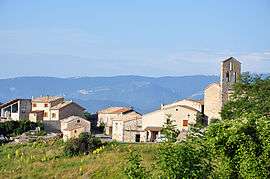
The church and surrounding buildings in Sigoyer | ||
| ||
 Sigoyer | ||
|
Location within Provence-A.-C.d'A. region  Sigoyer | ||
| Coordinates: 44°19′12″N 5°57′32″E / 44.32°N 5.9589°ECoordinates: 44°19′12″N 5°57′32″E / 44.32°N 5.9589°E | ||
| Country | France | |
| Region | Provence-Alpes-Côte d'Azur | |
| Department | Alpes-de-Haute-Provence | |
| Arrondissement | Forcalquier | |
| Canton | La Motte-du-Caire | |
| Government | ||
| • Mayor (2008–2014) | Michel Hernandez | |
| Area1 | 15.3 km2 (5.9 sq mi) | |
| Population (2008)2 | 86 | |
| • Density | 5.6/km2 (15/sq mi) | |
| Time zone | CET (UTC+1) | |
| • Summer (DST) | CEST (UTC+2) | |
| INSEE/Postal code | 04207 / 04200 | |
| Elevation |
482–945 m (1,581–3,100 ft) (avg. 832 m or 2,730 ft) | |
|
1 French Land Register data, which excludes lakes, ponds, glaciers > 1 km² (0.386 sq mi or 247 acres) and river estuaries. 2 Population without double counting: residents of multiple communes (e.g., students and military personnel) only counted once. | ||

Sigoyer is a commune in the Alpes-de-Haute-Provence department in southeastern France.
Population
| Historical population | ||
|---|---|---|
| Year | Pop. | ±% |
| 1765 | 256 | — |
| 1793 | 237 | −7.4% |
| 1800 | 257 | +8.4% |
| 1806 | 286 | +11.3% |
| 1821 | 240 | −16.1% |
| 1831 | 242 | +0.8% |
| 1836 | 242 | +0.0% |
| 1841 | 217 | −10.3% |
| 1846 | 230 | +6.0% |
| 1851 | 236 | +2.6% |
| 1856 | 230 | −2.5% |
| 1861 | 240 | +4.3% |
| 1866 | 240 | +0.0% |
| 1872 | 227 | −5.4% |
| 1876 | 218 | −4.0% |
| 1881 | 206 | −5.5% |
| 1886 | 190 | −7.8% |
| 1891 | 161 | −15.3% |
| 1896 | 161 | +0.0% |
| 1901 | 162 | +0.6% |
| 1906 | 151 | −6.8% |
| 1911 | 150 | −0.7% |
| 1921 | 128 | −14.7% |
| 1926 | 120 | −6.2% |
| 1931 | 109 | −9.2% |
| 1936 | 113 | +3.7% |
| 1946 | 89 | −21.2% |
| 1954 | 89 | +0.0% |
| 1962 | 71 | −20.2% |
| 1968 | 70 | −1.4% |
| 1975 | 72 | +2.9% |
| 1982 | 83 | +15.3% |
| 1990 | 88 | +6.0% |
| 1999 | 75 | −14.8% |
| 2008 | 86 | +14.7% |
See also
References
| Wikimedia Commons has media related to Sigoyer, Alpes-de-Haute-Provence. |
This article is issued from Wikipedia - version of the 2/4/2015. The text is available under the Creative Commons Attribution/Share Alike but additional terms may apply for the media files.