Saint-Vincent-les-Forts
| Saint-Vincent-les-Forts | ||
|---|---|---|
|
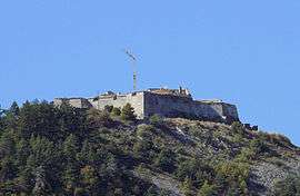
Fort Joubert | ||
| ||
 Saint-Vincent-les-Forts | ||
|
Location within Provence-A.-C.d'A. region  Saint-Vincent-les-Forts | ||
| Coordinates: 44°26′46″N 6°22′27″E / 44.4461°N 6.3742°ECoordinates: 44°26′46″N 6°22′27″E / 44.4461°N 6.3742°E | ||
| Country | France | |
| Region | Provence-Alpes-Côte d'Azur | |
| Department | Alpes-de-Haute-Provence | |
| Arrondissement | Barcelonnette | |
| Canton | Le Lauzet-Ubaye | |
| Intercommunality | Ubaye Serre-Ponçon | |
| Government | ||
| • Mayor (2008–2014) | Philippe Jaunay | |
| Area1 | 22.82 km2 (8.81 sq mi) | |
| Population (2008)2 | 264 | |
| • Density | 12/km2 (30/sq mi) | |
| Time zone | CET (UTC+1) | |
| • Summer (DST) | CEST (UTC+2) | |
| INSEE/Postal code | 04198 / 04340 | |
| Elevation |
770–2,500 m (2,530–8,200 ft) (avg. 1,300 m or 4,300 ft) | |
|
1 French Land Register data, which excludes lakes, ponds, glaciers > 1 km² (0.386 sq mi or 247 acres) and river estuaries. 2 Population without double counting: residents of multiple communes (e.g., students and military personnel) only counted once. | ||
.svg.png)
Saint-Vincent-les-Forts is a commune in the Alpes-de-Haute-Provence department in southeastern France.
Population
| Historical population | ||
|---|---|---|
| Year | Pop. | ±% |
| 1765 | 643 | — |
| 1793 | 596 | −7.3% |
| 1800 | 514 | −13.8% |
| 1806 | 637 | +23.9% |
| 1821 | 473 | −25.7% |
| 1831 | 626 | +32.3% |
| 1836 | 769 | +22.8% |
| 1841 | 242 | −68.5% |
| 1846 | 708 | +192.6% |
| 1851 | 679 | −4.1% |
| 1856 | 617 | −9.1% |
| 1861 | 614 | −0.5% |
| 1866 | 553 | −9.9% |
| 1872 | 521 | −5.8% |
| 1876 | 529 | +1.5% |
| 1881 | 534 | +0.9% |
| 1886 | 485 | −9.2% |
| 1891 | 566 | +16.7% |
| 1896 | 563 | −0.5% |
| 1901 | 544 | −3.4% |
| 1906 | 471 | −13.4% |
| 1911 | 491 | +4.2% |
| 1921 | 385 | −21.6% |
| 1926 | 330 | −14.3% |
| 1931 | 327 | −0.9% |
| 1936 | 333 | +1.8% |
| 1946 | 289 | −13.2% |
| 1954 | 249 | −13.8% |
| 1962 | 221 | −11.2% |
| 1968 | 215 | −2.7% |
| 1975 | 185 | −14.0% |
| 1982 | 195 | +5.4% |
| 1990 | 168 | −13.8% |
| 1999 | 203 | +20.8% |
| 2008 | 264 | +30.0% |
See also
References
| Wikimedia Commons has media related to Saint-Vincent-les-Forts. |
This article is issued from Wikipedia - version of the 3/18/2013. The text is available under the Creative Commons Attribution/Share Alike but additional terms may apply for the media files.