Moriez
| Moriez | ||
|---|---|---|
|
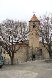
The church in Moriez | ||
| ||
 Moriez | ||
|
Location within Provence-A.-C.d'A. region  Moriez | ||
| Coordinates: 43°57′45″N 6°28′17″E / 43.9625°N 6.4714°ECoordinates: 43°57′45″N 6°28′17″E / 43.9625°N 6.4714°E | ||
| Country | France | |
| Region | Provence-Alpes-Côte d'Azur | |
| Department | Alpes-de-Haute-Provence | |
| Arrondissement | Castellane | |
| Canton | Saint-André-les-Alpes | |
| Intercommunality | Moyen Verdon | |
| Government | ||
| • Mayor (2008–2014) | Alain Coullet | |
| Area1 | 37.18 km2 (14.36 sq mi) | |
| Population (2008)2 | 183 | |
| • Density | 4.9/km2 (13/sq mi) | |
| Time zone | CET (UTC+1) | |
| • Summer (DST) | CEST (UTC+2) | |
| INSEE/Postal code | 04133 / 04170 | |
| Elevation |
820–1,700 m (2,690–5,580 ft) (avg. 900 m or 3,000 ft) | |
|
1 French Land Register data, which excludes lakes, ponds, glaciers > 1 km² (0.386 sq mi or 247 acres) and river estuaries. 2 Population without double counting: residents of multiple communes (e.g., students and military personnel) only counted once. | ||

Moriez is a commune in the Alpes-de-Haute-Provence department in southeastern France.
Population
| Historical population | ||
|---|---|---|
| Year | Pop. | ±% |
| 1765 | 689 | — |
| 1793 | 886 | +28.6% |
| 1800 | 639 | −27.9% |
| 1806 | 644 | +0.8% |
| 1821 | 850 | +32.0% |
| 1831 | 723 | −14.9% |
| 1836 | 700 | −3.2% |
| 1841 | 637 | −9.0% |
| 1846 | 646 | +1.4% |
| 1851 | 563 | −12.8% |
| 1856 | 575 | +2.1% |
| 1861 | 571 | −0.7% |
| 1866 | 535 | −6.3% |
| 1872 | 501 | −6.4% |
| 1876 | 466 | −7.0% |
| 1881 | 463 | −0.6% |
| 1886 | 460 | −0.6% |
| 1891 | 659 | +43.3% |
| 1896 | 415 | −37.0% |
| 1901 | 380 | −8.4% |
| 1906 | 373 | −1.8% |
| 1911 | 358 | −4.0% |
| 1921 | 299 | −16.5% |
| 1926 | 284 | −5.0% |
| 1931 | 258 | −9.2% |
| 1936 | 256 | −0.8% |
| 1946 | 240 | −6.2% |
| 1954 | 203 | −15.4% |
| 1962 | 195 | −3.9% |
| 1968 | 188 | −3.6% |
| 1975 | 168 | −10.6% |
| 1982 | 170 | +1.2% |
| 1990 | 160 | −5.9% |
| 1999 | 178 | +11.3% |
| 2008 | 183 | +2.8% |
See also
References
| Wikimedia Commons has media related to Moriez. |
This article is issued from Wikipedia - version of the 2/3/2015. The text is available under the Creative Commons Attribution/Share Alike but additional terms may apply for the media files.