Gretna, Virginia
| Gretna, Virginia | |
|---|---|
| Town | |
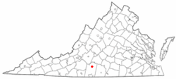 Location of Gretna, Virginia | |
| Coordinates: 36°57′11″N 79°21′46″W / 36.95306°N 79.36278°WCoordinates: 36°57′11″N 79°21′46″W / 36.95306°N 79.36278°W | |
| Country | United States |
| State | Virginia |
| County | Pittsylvania |
| Government | |
| • Type | Council-Manager |
| • Mayor | R. Keith Motley |
| • Town Council |
Michael Bond Mike Burnette James Gilbert Dianne Jennings Deborah Moran H. Wayne Wood |
| Area | |
| • Total | 1.1 sq mi (2.8 km2) |
| • Land | 1.1 sq mi (2.8 km2) |
| • Water | 0.0 sq mi (0.0 km2) |
| Elevation | 833 ft (254 m) |
| Population (2000) | |
| • Total | 1,257 |
| • Density | 1,172.8/sq mi (452.8/km2) |
| Time zone | Eastern (EST) (UTC-5) |
| • Summer (DST) | EDT (UTC-4) |
| ZIP code | 24557 |
| Area code(s) | 434 |
| FIPS code | 51-33232[1] |
| GNIS feature ID | 1467538[2] |
| Website | Official website |
Gretna is a town in Pittsylvania County, Virginia, United States. The population was 1,257 at the 2000 census. It is part of the Danville Metropolitan Statistical Area.
History
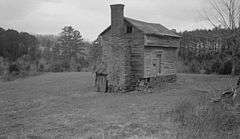
The Gretna Commercial Historic District and Yates Tavern are listed on the National Register of Historic Places.[3][4]
Geography
Gretna is located at 36°57′11″N 79°21′46″W / 36.95306°N 79.36278°W (36.953190, -79.362769).[5]
According to the United States Census Bureau, the town has a total area of 1.1 square miles (2.8 km²), of which, 1.1 square miles (2.8 km²) of it is land and 0.04 square miles (0.1 km²) of it (1.83%) is water.
Demographics
| Historical population | |||
|---|---|---|---|
| Census | Pop. | %± | |
| 1910 | 330 | — | |
| 1920 | 470 | 42.4% | |
| 1930 | 637 | 35.5% | |
| 1940 | 619 | −2.8% | |
| 1950 | 803 | 29.7% | |
| 1960 | 900 | 12.1% | |
| 1970 | 986 | 9.6% | |
| 1980 | 1,255 | 27.3% | |
| 1990 | 1,339 | 6.7% | |
| 2000 | 1,257 | −6.1% | |
| 2010 | 1,267 | 0.8% | |
| Est. 2015 | 1,248 | [6] | −1.5% |
As of the census[1] of 2000, there were 1,257 people, 569 households, and 326 families residing in the town. The population density was 1,172.8 people per square mile (453.6/km²). There were 635 housing units at an average density of 592.5 per square mile (229.1/km²). The racial makeup of the town was 60.54% White, 38.90% African American, 0.08% Native American, 0.08% Asian, 0.16% from other races, and 0.24% from two or more races. Hispanic or Latino of any race were 0.40% of the population.
There were 569 households out of which 20.7% had children under the age of 18 living with them, 36.6% were married couples living together, 18.3% had a female householder with no husband present, and 42.7% were non-families. 40.4% of all households were made up of individuals and 22.0% had someone living alone who was 65 years of age or older. The average household size was 2.06 and the average family size was 2.75.
In the town the population was spread out with 18.4% under the age of 18, 4.7% from 18 to 24, 21.7% from 25 to 44, 23.9% from 45 to 64, and 31.3% who were 65 years of age or older. The median age was 50 years. For every 100 females there were 74.1 males. For every 100 females age 18 and over, there were 67.9 males.
The median income for a household in the town was $23,710, and the median income for a family was $33,611. Males had a median income of $28,158 versus $20,598 for females. The per capita income for the town was $14,397. About 14.4% of families and 19.3% of the population were below the poverty line, including 27.7% of those under age 18 and 20.7% of those age 65 or over.
References
- 1 2 "American FactFinder". United States Census Bureau. Retrieved 2008-01-31.
- ↑ "US Board on Geographic Names". United States Geological Survey. 2007-10-25. Retrieved 2008-01-31.
- ↑ National Park Service (2010-07-09). "National Register Information System". National Register of Historic Places. National Park Service.
- ↑ "National Register of Historic Places Listings". Weekly List of Actions Taken on Properties: 5/28/13 through 5/31/13. National Park Service. 2013-06-07.
- ↑ "US Gazetteer files: 2010, 2000, and 1990". United States Census Bureau. 2011-02-12. Retrieved 2011-04-23.
- ↑ "Annual Estimates of the Resident Population for Incorporated Places: April 1, 2010 to July 1, 2015". Retrieved July 2, 2016.
- ↑ "Census of Population and Housing". Census.gov. Retrieved June 4, 2015.