Stanardsville, Virginia
| Stanardsville, Virginia | |
|---|---|
| Town | |
 Location of Orange, Virginia | |
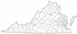
 Stanardsville, Virginia Location in the United States | |
| Coordinates: 38°17′49″N 78°26′22″W / 38.29694°N 78.43944°WCoordinates: 38°17′49″N 78°26′22″W / 38.29694°N 78.43944°W | |
| Country | United States |
| State | Virginia |
| County | Greene |
| Area | |
| • Total | 0.3 sq mi (0.9 km2) |
| • Land | 0.3 sq mi (0.9 km2) |
| • Water | 0.0 sq mi (0.0 km2) |
| Elevation | 663 ft (202 m) |
| Population (2000) | |
| • Total | 476 |
| • Density | 1,361.0/sq mi (525.5/km2) |
| Time zone | Eastern (EST) (UTC-5) |
| • Summer (DST) | EDT (UTC-4) |
| ZIP code | 22973 |
| Area code(s) | 434 |
| FIPS code | 51-75008[1] |
| GNIS feature ID | 1500151[2] |
Stanardsville is a town in Greene County, Virginia, United States. The population was 476 at the 2000 census. It is the county seat of Greene County.[3] The name is from Robert Stanard, a benefactor who donated land for public use. It is part of the Charlottesville Metropolitan Statistical Area.
History
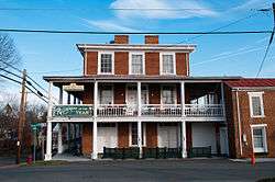
The Greene County Courthouse, Beadles House, Octonia Stone, Powell-McMullan House, and Stanardsville Historic District are listed on the National Register of Historic Places.[4]
Geography
Stanardsville is located at 38°17′49″N 78°26′22″W / 38.29694°N 78.43944°W (38.296852, -78.439367).[5]
According to the United States Census Bureau, the town has a total area of 0.3 square miles (0.9 km²), all of it land.
Stanardsville is at the junction of U.S. Route 33 and State Highway 230.
Demographics
| Historical population | |||
|---|---|---|---|
| Census | Pop. | %± | |
| 1930 | 229 | — | |
| 1940 | 212 | −7.4% | |
| 1950 | 182 | −14.2% | |
| 1960 | 283 | 55.5% | |
| 1970 | 296 | 4.6% | |
| 1980 | 284 | −4.1% | |
| 1990 | 257 | −9.5% | |
| 2000 | 476 | 85.2% | |
| 2010 | 367 | −22.9% | |
| Est. 2015 | 380 | [6] | 3.5% |
As of the census[1] of 2000, there were 476 people, 183 households, and 116 families residing in the town. The population density was 1,361.0 people per square mile (525.1/km²). There were 196 housing units at an average density of 560.4 per square mile (216.2/km²). The racial makeup of the town was 88.87% White, 8.61% African American, 0.21% Native American, 1.05% from other races, and 1.26% from two or more races. Hispanic or Latino of any race were 0.84% of the population.
There were 183 households out of which 31.1% had children under the age of 18 living with them, 34.4% were married couples living together, 21.9% had a female householder with no husband present, and 36.6% were non-families. 34.4% of all households were made up of individuals and 14.2% had someone living alone who was 65 years of age or older. The average household size was 2.21 and the average family size was 2.73.
In the town the population was spread out with 23.3% under the age of 18, 6.9% from 18 to 24, 22.5% from 25 to 44, 17.9% from 45 to 64, and 29.4% who were 65 years of age or older. The median age was 41 years. For every 100 females there were 74.4 males. For every 100 females age 18 and over, there were 65.2 males.
The median income for a household in the town was $24,643, and the median income for a family was $33,750. Males had a median income of $24,583 versus $18,889 for females. The per capita income for the town was $21,317. About 14.3% of families and 15.1% of the population were below the poverty line, including 24.5% of those under age 18 and 11.4% of those age 65 or over.
References
- 1 2 "American FactFinder". United States Census Bureau. Retrieved 2008-01-31.
- ↑ "US Board on Geographic Names". United States Geological Survey. 2007-10-25. Retrieved 2008-01-31.
- ↑ "Find a County". National Association of Counties. Retrieved 2011-06-07.
- ↑ National Park Service (2010-07-09). "National Register Information System". National Register of Historic Places. National Park Service.
- ↑ "US Gazetteer files: 2010, 2000, and 1990". United States Census Bureau. 2011-02-12. Retrieved 2011-04-23.
- ↑ "Annual Estimates of the Resident Population for Incorporated Places: April 1, 2010 to July 1, 2015". Retrieved July 2, 2016.
- ↑ "Census of Population and Housing". Census.gov. Retrieved June 4, 2015.
Further reading
- Historic buildings on Stanardsville, Virginia by Gina Haney and Donald Covey. Published by Stanardsville Chamber of Commerce. No ISBN.
External links
Municipalities and communities of Greene County, Virginia, United States | ||
|---|---|---|
| Town | 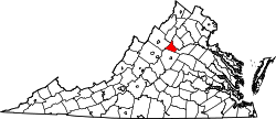 | |
| CDPs | ||
| Unincorporated communities | ||